Geothermal power in Iceland
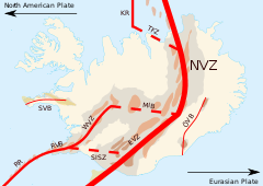
Due to the geological location of Iceland (over a rift in continental plates), the high concentration of volcanoes in the area is often an advantage in the generation of geothermal energy, the heating and making of electricity.[1] During winter, pavements near these areas (such as Reykjavik and Akureyri) are heated up.

Five major geothermal power plants exist in Iceland, which produce approximately 26.2% (2010)[2] of the nation's electricity. In addition, geothermal heating meets the heating and hot water requirements of approximately 87% of all buildings in Iceland. Apart from geothermal energy, 73.8% of the nation's electricity is generated by hydro power,[2] and 0.1% from fossil fuels.[3] Hydrogen sulfide (H2S) from geothermal energy may have impacted the health of Icelanders.[4]
Consumption of primary geothermal energy in 2004 was 79.7 petajoules (PJ), approximately 53.4% of the total national consumption of primary energy, 149.1 PJ. The corresponding share for hydro power was 17.2%, petroleum was 26.3%, and coal was 3%.[5] Plans are underway to turn Iceland into a 100% fossil-fuel-free nation in the near future.[6] For example, Iceland's abundant geothermal energy has enabled renewable energy initiatives, such as Carbon Recycling International's carbon dioxide to methanol fuel process.[7]
Geothermal energy also provides tourist attractions such as the Blue Lagoon. The geothermal water originates 2,000 metres below the surface, where freshwater and seawater combine at extreme temperatures. It is then harnessed via drilling holes at a nearby geothermal power plant, Svartsengi, to create electricity and hot water for nearby communities. This Blue Lagoon is entirely powered by geothermal energy.[8]
The following are the six largest power stations in Iceland:[9]
- Hellisheiði Power Station (303 MW)
- Nesjavellir Geothermal Power Station (120 MW)
- Reykjanes Power Station (100 MW)
- Svartsengi Power Station (76.5 MW)
- Krafla Power Station (60 MW)
- Þeistareykir Power Station (45 MW)
See also
- List of power stations in Iceland
- Renewable energy in Iceland
- The Geothermal energy exhibition
- Iceland Deep Drilling Project
- Renewable energy by country
References
- Icelandic Energy Portal
- "Raforkuvinnsla". landsvirkjun.is (in Icelandic). Archived from the original on 2012-10-31. Retrieved 2015-04-30.
- Ministry of Industries and Innovation, Iceland (19 March 2014). "The Icelandic National Renewable Energy Action Plan for the promotion of the use of energy from renewable sources in accordance with Directive 2009/28/EC and the Commission Decision of 30 June 2009 on a template for the national renewable energy action plans" (PDF). European Commission. p. 3.
- Finnbjornsdottir, Ragnhildur Gudrun; et al. (April 8, 2015). "Hydrogen sulfide and traffic-related air pollutants in association with increased mortality: a case-crossover study in Reykjavik, Iceland". BMJ Open. 5 (4). doi:10.1136/bmjopen-2014-007272.
- "Energy in Iceland - Historical Perspective, Present Status, Future Outlook" (PDF). Orkustofnun (Iceland Energy Authority). Archived from the original (PDF) on 2004-11-09. Retrieved 2006-09-20.
- "Energy Statistics in Iceland" (PDF). Orkustofnun (Iceland Energy Authority). Retrieved 2006-09-20.
- "Technology". Carbon Recycling International. 2011. Archived from the original on 17 June 2013. Retrieved 11 July 2012.
- Badaoui, Bachir. "Geothermal Energy - Blue Lagoon". Smithsonian.com.
- Icelandic Energy Portal
External links
- Iceland Energy Authority
- Icelandic Energy Portal
- More information about Svartsengi power-plant
- More information about Nesjavellir power-plant
- More information about Krafla power-plant
- More information about Hellisheidi power-plant
- Photo Gallery from islandsmyndir.is
- Photo Geothermal power station Svartsengi
- Photos of Geothermal power plants at Reykjanes & Svartsengi
- Tiroler Bi
- Mannvit Engineering of Iceland
- RES - School for Renewable Energy Science in Iceland
- Keilir - Atlantic Center of Excellence
- Icelandic GeoSurvey
| Category:Geothermal energy | 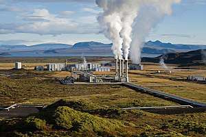 | |
|---|---|---|
| By country |
| |
| Technologies | ||
| Energy Concepts |
| |
| ||
| Africa |
| ||||
|---|---|---|---|---|---|
| Asia | |||||
| Europe |
| ||||
| North America | |||||
| Oceania | |||||
| South America | |||||
| |||||