Ing River
The Ing River (Thai: น้ำแม่อิง, RTGS: Nam Mae Ing, pronounced [náːm mɛ̂ː ʔīŋ]) is a tributary of the Mekong River in the northern part of Thailand. It has its source in Doi Luang, Phi Pan Nam Range, in Mae Chai District, Phayao Province. The Ing flows through the plain area of Thoeng District.[1]
| Ing River | |
|---|---|
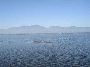 Phayao Lake. The Ing River flows northwards through this lake. | |
 Map of Thai highlands, including Ing River | |
| Native name | น้ำแม่อิง |
| Location | |
| Country | Thailand |
| State | Phayao Province, Chiang Rai Province |
| City | Phayao |
| Physical characteristics | |
| Source | |
| ⁃ location | Phi Pan Nam Range, Phayao Province, Thailand |
| Mouth | Mekong |
⁃ location | Sathan, Chiang Khong District, Chiang Rai Province |
⁃ coordinates | 20°12′19″N 100°27′3″E |
⁃ elevation | 346 m (1,135 ft) |
| Length | 300 km (190 mi) |
Course
The Ing is about 300 kilometres (190 mi) long and its flow varies seasonally due to the tropical forest climate in the region. Flood waters inundate the river basin during the rainy season, spurring migratory fish to enter the Ing from the larger Mekong for the purpose of spawning there. The intermittently flooded forest near its banks allow for ample spawning grounds for a wide variety of river-running fish. Many young and old fish go back downriver with the onset of the dry season. The native people of the Ing River watershed depend on catching migratory fish and other wild riverine animals for their survival. Locals rely upon seasonal fish and their migration, and have learned to catch them with great skill, especially through the use of hundreds of small reservoirs and ponds.
At the town Phayao the Ing River flows through Phayao Lake.