Ohio State Route 147
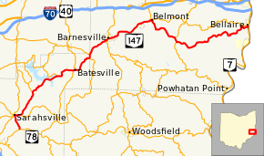
State Route 147 (SR 147) is an east-west state highway in the eastern portion of the U.S. state of Ohio. Its eastern terminus is at State Route 7 near Bellaire, with its western terminus at SR 78 in Noble County, Ohio. The highway passes near Senecaville Lake near Batesville.[2]
| ||||
|---|---|---|---|---|
 | ||||
| Route information | ||||
| Maintained by ODOT | ||||
| Length | 58.40 mi[1] (93.99 km) | |||
| Existed | 1923–present | |||
| Major junctions | ||||
| West end | ||||
| East end | ||||
| Location | ||||
| Counties | Noble, Belmont | |||
| Highway system | ||||
| ||||

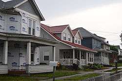
Houses in Bethesda
History
SR 147 was commissioned in 1923, along its current route.[3][4] In 1930, the western terminus was moved to an intersection to the newly commissioned SR 146, in Sarahsville.[5][6] The western terminus was moved back to its current location in 1932.[7][8]
Major intersections
| County | Location | mi[1] | km | Destinations | Notes |
|---|---|---|---|---|---|
| Noble | Center Township | 0.00 | 0.00 | ||
| Sarahsville | 2.60 | 4.18 | Western end of SR 146 concurrency | ||
| Center Township | 3.50 | 5.63 | Eastern end of SR 146 concurrency | ||
| Seneca Township | 8.06 | 12.97 | Southern terminus of SR 566 | ||
| Beaver Township | 13.56 | 21.82 | Eastern terminus of SR 313 | ||
| Batesville | 17.03 | 27.41 | Western end of SR 513 concurrency | ||
| 17.11 | 27.54 | Eastern end of SR 513 concurrency | |||
| Belmont | Somerset Township | 21.06 | 33.89 | Northern terminus of SR 379 | |
| Warren Township | 22.18 | 35.70 | Eastern terminus of SR 265 | ||
| Barnesville | 25.54 | 41.10 | Western end of SR 800 concurrency | ||
| 25.98 | 41.81 | Eastern end of SR 800 concurrency | |||
| Goshen Township | 34.19 | 55.02 | Western end of SR 149 concurrency | ||
| Belmont | 34.70 | 55.84 | Western end of SR 149 concurrency | ||
| Smith Township | 40.64 | 65.40 | Western end of SR 9 concurrency | ||
| 41.41 | 66.64 | Eastern end of SR 9 concurrency | |||
| Pultney Township | 58.23– 58.40 | 93.71– 93.99 | Interchange | ||
1.000 mi = 1.609 km; 1.000 km = 0.621 mi
| |||||
References
- Ohio Department of Transportation. "Technical Services Straight Line Diagrams". Retrieved October 13, 2013.
- Google (October 13, 2013). "Ohio State Route 147" (Map). Google Maps. Google. Retrieved October 13, 2013.
- Ohio Department of Highways and Public Works (April 1922). Map of Ohio State Highways Showing All Improved Roadways and Indicating System Constructed Under Administration of Gov. Harry L. Davis (PDF) (Map). c. 1:563,200. Columbus: Ohio Department of Highways and Public Works. Retrieved October 22, 2013.
- Ohio Department of Highways and Public Works (July 1923). Map of Ohio Showing State Routes (PDF) (Map). 1:760,320. Columbus: Ohio Department of Highways and Public Works. Retrieved October 22, 2013.
- Ohio Department of Highways (August 15, 1929). Map of Ohio Showing State Highway System (PDF) (Map). 1:760,320. Columbus: Ohio Department of Highways. OCLC 5673562, 7438560. Retrieved October 22, 2013.
- Ohio Department of Highways (1930). Map of Ohio Showing State Highway System (PDF) (Map). 1:760,320. Columbus: Ohio Department of Highways. OCLC 5673562, 7237073. Retrieved October 22, 2013.
- Ohio Department of Highways (1931). Map of Ohio Showing State Highway System (PDF) (Map). 1:760,320. Columbus: Ohio Department of Highways. OCLC 5673562, 7231737. Retrieved October 22, 2013.
- Ohio Department of Highways (1932). Map of Ohio Showing State Highway System (PDF) (Map). 1:760,320. Columbus: Ohio Department of Highways. OCLC 5673562, 7231704. Retrieved October 22, 2013.
This article is issued from Wikipedia. The text is licensed under Creative Commons - Attribution - Sharealike. Additional terms may apply for the media files.