Ohio State Route 331
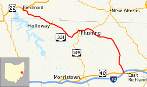
State Route 331 (SR 331, OH 331) is an east–west state highway in the eastern portion of the U.S. state of Ohio. State Route 331 has its western terminus at U.S. Route 22 approximately 4 miles (6.4 km) northwest of the village of Holloway. Its eastern terminus is at a signalized intersection with U.S. Route 40 nearly 2.75 miles (4.43 km) west of Saint Clairsville, and immediately south of Exit 213 off of Interstate 70.
| ||||
|---|---|---|---|---|
 | ||||
| Route information | ||||
| Maintained by ODOT | ||||
| Length | 18.48 mi[1] (29.74 km) | |||
| Existed | 1932[2][3]–present | |||
| Major junctions | ||||
| West end | ||||
| East end | ||||
| Location | ||||
| Counties | Harrison, Belmont | |||
| Highway system | ||||
| ||||

Route description
Along its way, State Route 331 passes through portions of Harrison and Belmont Counties. There are no stretches of State Route 331 that are incorporated within the National Highway System, a system of highways determined to be most important for the country's economy, mobility and defense.[4]
History
State Route 331 made its debut in 1932. Originally, the highway ran from its current western terminus at U.S. Route 22 northwest of Holloway to its current western junction with State Route 149 in Flushing.[2][3] In 1939, State Route 331 took on the shape that it has today when it was extended southeasterly from Flushing to its current eastern terminus at U.S. Route 40 west of Saint Clairsville.[5][6]
Major intersections
| County | Location | mi[1] | km | Destinations | Notes |
|---|---|---|---|---|---|
| Harrison | Moorefield Township | 0.00 | 0.00 | ||
| Belmont | Flushing | 8.96 | 14.42 | Western end of SR 149 concurrency | |
| Flushing Township | 10.66 | 17.16 | Eastern end of SR 149 concurrency | ||
| Richland Township | 18.07 | 29.08 | Exit 213 (I-70); access to I-70 eastbound and from I-70 westbound only | ||
| 18.21 | 29.31 | ||||
1.000 mi = 1.609 km; 1.000 km = 0.621 mi
| |||||
References
- Ohio Department of Transportation. "Technical Services Straight Line Diagrams". Retrieved 2010-11-11.
- Map of Ohio Showing State Highway System (MrSID) (Map). Cartography by ODOH. Ohio Department of Highways. 1931. Retrieved 2011-01-14.
- Map of Ohio Showing State Highway System (MrSID) (Map). Cartography by ODOH. Ohio Department of Highways. 1932. Retrieved 2011-01-14.
- National Highway System: Ohio (PDF) (Map). Federal Highway Administration. December 2003. Retrieved 2011-01-14.
- Official Ohio Highway Map (MrSID) (Map). Cartography by ODOH. Ohio Department of Highways. 1938. Retrieved 2011-01-14.
- Ohio Highway Map (MrSID) (Map). Cartography by ODOH. Ohio Department of Highways. 1939. Retrieved 2011-01-14.