Balaguier-d'Olt
Balaguier-d'Olt is a commune in the Aveyron department in the Occitanie region of southern France.
Balaguier-d'Olt | |
|---|---|
Location of Balaguier-d'Olt 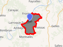
| |
 Balaguier-d'Olt  Balaguier-d'Olt | |
| Coordinates: 44°31′29″N 1°58′23″E | |
| Country | France |
| Region | Occitanie |
| Department | Aveyron |
| Arrondissement | Villefranche-de-Rouergue |
| Canton | Lot et Montbazinois |
| Government | |
| • Mayor (2008–2020) | Yves Villa |
| Area 1 | 10.84 km2 (4.19 sq mi) |
| Population (2017-01-01)[1] | 162 |
| • Density | 15/km2 (39/sq mi) |
| Time zone | UTC+01:00 (CET) |
| • Summer (DST) | UTC+02:00 (CEST) |
| INSEE/Postal code | 12018 /12260 |
| Elevation | 152–378 m (499–1,240 ft) (avg. 150 m or 490 ft) |
| 1 French Land Register data, which excludes lakes, ponds, glaciers > 1 km2 (0.386 sq mi or 247 acres) and river estuaries. | |
The inhabitants of the commune are known as Balaguiérois or Balaguiéroises.[2]
Geography
Balaguier-d'Olt is located some 12 km south-west of Figeac just east of Ambeyrac. The whole north-western border of the commune is the Lot river which is also the departmental boundary between Aveyron and Lot. Access to the commune is by the D86 road from Ambeyrac which follows the river through the village and continues north-east to Capdenac-Gare. The D38 branches off the D86 and crosses the only bridge in the commune across the Lot to Saint-Pierre-Toirac. The D647 branches off the D86 just north of the village and goes south-east to Foissac. Apart from the village there is the hamlet of Vernet-le-Bas in the north of the commune. The commune is mixed forest and farmland.[3]
Geologically the commune is divided into two parts: first the Lot valley which consists of Toarcian marl and secondly the limestone plateau overlooking it.
The Ruisseau de Bournac flows from the north-east and the Ruisseau de Fréjéroque flows from the east both joining in the commune and flowing into the Lot.[3]
Neighbouring communes and villages[3]
Places adjacent to Balaguier-d'Olt | ||||||||||
|---|---|---|---|---|---|---|---|---|---|---|
| ||||||||||
Administration
| From | To | Name | Party | Position |
|---|---|---|---|---|
| 1840 | 1848 | Joseph Daube | ||
| 1848 | 1860 | Pierre Trenty | ||
| 1860 | 1868 | Jean Louis Obscur | ||
| 1868 | 1904 | Félix Vernet | ||
| 2001 | 2008 | Claude Roques | ||
| 2008 | 2020 | Yves Ville |
(Not all data is known)
Demography
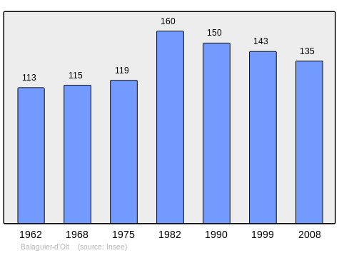
In 2010 the commune had 127 inhabitants. The evolution of the number of inhabitants is known from the population censuses conducted in the commune since 1793. From the 21st century, a census of communes with fewer than 10,000 inhabitants is held every five years, unlike larger communes that have a sample survey every year.[Note 1]
| 1793 | 1800 | 1806 | 1821 | 1831 | 1836 | 1841 | 1846 | 1851 |
|---|---|---|---|---|---|---|---|---|
| 485 | 414 | - | - | - | - | 619 | 632 | 635 |
| 1856 | 1861 | 1866 | 1872 | 1876 | 1881 | 1886 | 1891 | 1896 |
|---|---|---|---|---|---|---|---|---|
| 619 | 621 | 578 | 574 | 536 | 516 | 531 | 510 | 415 |
| 1901 | 1906 | 1911 | 1921 | 1926 | 1931 | 1936 | 1946 | 1954 |
|---|---|---|---|---|---|---|---|---|
| 377 | 340 | 316 | 256 | 251 | 221 | 238 | 214 | 163 |
| 1962 | 1968 | 1975 | 1982 | 1990 | 1999 | 2006 | 2010 | - |
|---|---|---|---|---|---|---|---|---|
| 113 | 115 | 119 | 160 | 150 | 143 | 144 | 127 | - |
Sites and Monuments
The Romanesque Church of Vernet-le-Bas has a bell tower dating from the 12th century and has Romanesque capitals on three sides. Inside the church the Romanesque Altar (12th century)![]()
See also
Bibliography
- Christian-Pierre Bedel (preface Jacques Dournes), Capdenac Los Aures Asprièras, Balaguier, Bolhac, Causse-e-Diege Foissac, Naussac, Salas, Sonnac / Christian-Pierre Bedel e los estatjants del canton de Capdenac, Rodez, Mission departmental culture, coll. "Al Canton", 1996, ill., cov. ill., 28 cm, 240 pp. ISBN 2-907279-23-8, ISSN 1151-8375, BNF No. FRBNF36688708 (in French)
External links
- Balaguier-d'Olt on Lion1906
- Balaguier-d'Olt on Google Maps
- Balaguier-d'Olt on Géoportail, National Geographic Institute (IGN) website (in French)
- Balaguyer on the 1750 Cassini Map
- Balaguier-d'Olt on the INSEE website (in French)
- INSEE (in French)
Notes and references
Notes
- At the beginning of the 21st century, the methods of identification have been modified by Law No. 2002-276 of 27 February 2002 Archived 6 March 2016 at the Wayback Machine, the so-called "law of local democracy" and in particular Title V "census operations" allows, after a transitional period running from 2004 to 2008, the annual publication of the legal population of the different French administrative districts. For communes with a population greater than 10,000 inhabitants, a sample survey is conducted annually, the entire territory of these communes is taken into account at the end of the period of five years. The first "legal population" after 1999 under this new law came into force on 1 January 2009 and was based on the census of 2006.
References
- "Populations légales 2017". INSEE. Retrieved 6 January 2020.
- Inhabitants of Aveyron (in French)
- Google Maps
- List of Mayors of France (in French)
- Ministry of Culture, Palissy PM12000015 Altar (in French)
| Wikimedia Commons has media related to Balaguier-d'Olt. |
| Authority control |
|
|---|