Arrosès
Arrosès is a commune in the Pyrénées-Atlantiques department in the Nouvelle-Aquitaine region of south-western France.
Arrosès | |
|---|---|
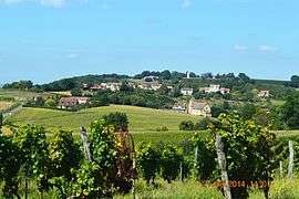 A general view of Arrosès | |
Location of Arrosès 
| |
 Arrosès  Arrosès | |
| Coordinates: 43°32′32″N 0°06′37″W | |
| Country | France |
| Region | Nouvelle-Aquitaine |
| Department | Pyrénées-Atlantiques |
| Arrondissement | Pau |
| Canton | Terres des Luys et Coteaux du Vic-Bilh |
| Intercommunality | Nord-Est Béarn |
| Government | |
| • Mayor (2014-2020) | Michel Cantounet |
| Area 1 | 9.64 km2 (3.72 sq mi) |
| Population (2017-01-01)[1] | 139 |
| • Density | 14/km2 (37/sq mi) |
| Time zone | UTC+01:00 (CET) |
| • Summer (DST) | UTC+02:00 (CEST) |
| INSEE/Postal code | 64056 /64350 |
| Elevation | 129–265 m (423–869 ft) (avg. 226 m or 741 ft) |
| 1 French Land Register data, which excludes lakes, ponds, glaciers > 1 km2 (0.386 sq mi or 247 acres) and river estuaries. | |
Geography
Arrosès is located some 50 km south-east of Hagetmau and some 5 km west of Madiran with the eastern border of the commune being the border between Pyrénées-Atlantiques and Hautes-Pyrénées departments. Access to the commune is by the D219 road from Aurions-Idernes in the west passing through the commune north of the village then continuing east to Madiran as the D66. The D292 comes from Aubous in the north passing through the commune and the village and continuing south to join the D139 south of Crouseilles. The commune is mostly farmland with patches of forest scattered throughout.[2]
The commune is located in the Drainage basin of the Adour with several streams rising in the commune and flowing east to join the Saget which flows north to join the Adour near Saint-Mont and forming most of the eastern border of the commune. The Larcis forms most of the western border of the commune as it flows north to join the Lees.
Places and Hamlets
Neighbouring communes and villages
Places adjacent to Arrosès | |
|---|---|
Toponymy
The commune name in béarnais is Arrosés.
Michel Grosclaude proposed as its etymology the anthroponym Arrosés which was very common in the Pyrenees and the Iberian peninsula and well attested in the Middle Ages.[7]
The following table details the origins of the commune name and other names in the commune.
| Name | Spelling | Date | Source | Page | Origin | Description |
|---|---|---|---|---|---|---|
| Arrosès | Aroses | 1385 | Raymond | Census | Village | |
| Arozee | 14th century | Raymond | Census | |||
| Arosser | 14th century | Raymond | Census | |||
| Arozer | 14th century | Raymond | Census | |||
| Arroser | 1402 | Raymond | Census | |||
| Rosees | 1472 | Raymond | Affièvement | |||
| Arrosers | 1487 | Raymond | Establishments | |||
| Rosses | 1538 | Raymond | Reformation | |||
| Arrosees | 1538 | Raymond | Reformation | |||
| Arrozes | 1546 | Raymond | Reformation | |||
| Rosez | 1675 | Raymond | Reformation | |||
| Arrouzès | 1686 | Raymond | Reformation | |||
| Rosés | 1750 | Cassini | ||||
| Arroses | 1793 | Ldh/EHESS/Cassini | ||||
| Arblé | Arblé | 1863 | Raymond | Moor | ||
| Baradat | Baradat | 1863 | Raymond | Farm | ||
| La Barthe | La Barthe | 1863 | Raymond | Moor | ||
| Chaudelet | Chaudelet | 1863 | Raymond | Farm | ||
| Crestia | Crestiàa | 1863 | Raymond | Place | ||
| Espiau | Espiau | 1863 | Raymond | Place | ||
| Les Garbères | Les Garbères | 1863 | Raymond | Farm | ||
| Le Gog | Le Gog | 1863 | Raymond | Farm | ||
| Les Grabes | Les Grabes | 1863 | Raymond | Farm | ||
| Lamothe | Lamothe | 1863 | Raymond | Mill | ||
| Larbareng | Larbareng | 1863 | Raymond | Place | ||
| Lorthe | Lorthe | 1863 | Raymond | Place | ||
| Mané | Mané | 1863 | Raymond | Farm | ||
| La Mothe | La Mota d'Arroses | 1538 | Raymond | Reformation | Fief, vassal of the Viscounts of Béarn | |
| La Motte | 1863 | Raymond | ||||
| Peirolis | Peirolis | 1863 | Raymond | Farm | ||
| La Salle | Lasalle | 1776 | Raymond | Terrier | Farm | |
| Sinsoos | Sinsoos | 1863 | Raymond | Farm |
Sources:
- Raymond: Topographic Dictionary of the Department of Basses-Pyrenees, 1863, on the page numbers indicated in the table. (in French)[3]
- Grosclaude: Toponymic Dictionary of communes, Béarn, 2006 (in French)[7]
- Cassini: Cassini Map from 1750[8]
- Ldh/EHESS/Cassini: Ldh/EHESS/Cassini database (in French)
Origins:
History
Paul Raymond noted on page 13 of his 1863 dictionary that in 1385, Arrosès had 31 fires and depended on the bailiwick of Lembeye. There was a Tithe in Arrosès parish called Sainte-Rose.[3]
Administration
List of Successive Mayors[13]
| From | To | Name | Party | Position |
|---|---|---|---|---|
| 1995 | 2001 | Francis Cazenave | ||
| 2001 | 2008 | Gérard Saint-Martin | ||
| 2008 | 2014 | Christian Labat | ||
| 2014 | 2020 | Michel Cantounet |
(Not all data is known)
Inter-communality
The commune is part of five inter-communal structures:
- the Community of communes of the Canton of Lembeye in Vib-Bihl;
- the highways SIVU of the Canton of Lembeye
- the AEP association of Crouseilles;
- the SIVU for educational regrouping in Aurions-idernes, Arrosès, Séméacq-Blachon, and Moncaup;
- the Energy association of Pyrénées-Atlantiques;
Demography
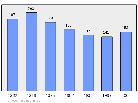
In 2010 the commune had 148 inhabitants. The evolution of the number of inhabitants is known from the population censuses conducted in the commune since 1793. From the 21st century, a census of communes with fewer than 10,000 inhabitants is held every five years, unlike larger towns that have a sample survey every year.[Note 1]
| 1793 | 1800 | 1806 | 1821 | 1831 | 1836 | 1841 | 1846 | 1851 |
|---|---|---|---|---|---|---|---|---|
| 466 | 358 | 454 | 463 | 517 | 554 | 645 | 679 | 621 |
| 1856 | 1861 | 1866 | 1872 | 1876 | 1881 | 1886 | 1891 | 1896 |
|---|---|---|---|---|---|---|---|---|
| 597 | 515 | 504 | 492 | 486 | 462 | 478 | 414 | 415 |
| 1901 | 1906 | 1911 | 1921 | 1926 | 1931 | 1936 | 1946 | 1954 |
|---|---|---|---|---|---|---|---|---|
| 403 | 332 | 310 | 259 | 267 | 223 | 216 | 198 | 183 |
| 1962 | 1968 | 1975 | 1982 | 1990 | 1999 | 2006 | 2010 | - |
|---|---|---|---|---|---|---|---|---|
| 187 | 203 | 178 | 159 | 145 | 141 | 149 | 148 | - |
Economy
The town is part of the Appellation d'origine contrôlée (AOC) zones of Madiran, Pacherenc-du-vic-bilh, and Béarn AOC.
Culture and Heritage
Civil heritage
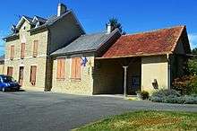
A number of structures have been identified as historical monuments. These are:
- A Fortified complex[14] (Motte-and-bailey castle, courtyard, house) indicates the presence of a lordship in the 11th century.
- Of 50 Houses and Farms[15] surveyed by the Ministry of Culture, 25 were built prior to 1871.
- The Chateau of Sauvernéa[6] at a place called Mombet is a notable house built in the 18th century. Other objects at Mombet are:
- A Farm at a place called Flandres from 1746.[5]
A Hilarri[4] located at a house in the Bouézou area dates to the 17th century. It came from the old church which is now destroyed.[19]
Religious heritage
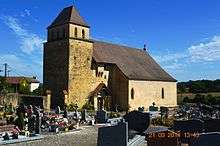
The Church of Our Lady of the Assumption[20] partially dates to the 12th century. It contains many items which have been registered. These are:
- Front of the Altar (19th century)[21]
- Processional Cross (17th or 18th century)[22]
- Stations of the Cross (19th century)[23]
- Altar candlestick (19th century)[24]
- Processional Banner (19th century)[25]
- Lectern (18th century)[26]
- Pulpit (18th century)[27]
- Tenebrae candlestick (18th century (?))[28]
- Stoup (2) (12th or 13th century)[29]
- Stoup (1) (15th or 16th century)[30]
- Baptismal font (12th and 17th centuries)[31]
- Confessional (18th century)[32]
- Statue: Saint Rose (18th century)[33]
- Retable of Saint Rose (18th century)[34]
- Altar, 2 altar steps, tabernacle, Retable, Painting (18th-19th centuries)[35]
- Altar Cross (19th century)[36]
- Painting: Assumption (18th century)[37]
- 4 Statues (18th century)[38]
- Retable (18th century)[39]
- 6 Statues (18th century (?))[40]
- Tabernacle, exhibit (18th century (?))[41]
- Altar (18th century)[42]
- Ensemble of the Virgin (18th-19th centuries)[43]
- Panelling on the surfaces (18th century)[44]
Notes
- At the beginning of the 21st century, the methods of identification have been modified by Law No. 2002-276 of 27 February 2002 Archived 6 March 2016 at the Wayback Machine, the so-called "law of local democracy" and in particular Title V "census operations" allows, after a transitional period running from 2004 to 2008, the annual publication of the legal population of the different French administrative districts. For communes with a population greater than 10,000 inhabitants, a sample survey is conducted annually, the entire territory of these communes is taken into account at the end of the period of five years. The first "legal population" after 1999 under this new law came into force on 1 January 2009 and was based on the census of 2006.
References
- "Populations légales 2017". INSEE. Retrieved 6 January 2020.
- Google Maps
- Topographic Dictionary of the Department of Basses-Pyrenees, Paul Raymond, Imprimerie nationale, 1863, Digitised from Lyon Public Library 15 June 2011 (in French)
- French Ministry of Culture Notice IM64002128 Hilarri (in French)
- French Ministry of Culture Notice IA00026449 Farm (in French)
- French Ministry of Culture Notice IA00026446 Chateau of Sauvernéa (in French)
- Michel Grosclaude, Toponymic Dictionary of communes, Béarn, Edicions reclams & Édition Cairn - 2006, 416 pages, ISBN 2-35068-005-3 (in French)
- Cassini Map 1750 – Arrosès
- Manuscript from the 14th century - Departmental Archives of Pyrénées-Atlantiques (in French)
- Manuscripts from the 15th and 16th centuries in the Departmental Archives of Pyrénées-Atlantiques (in French)
- Manuscript from the 16th to 18th centuries - Departmental Archives of Pyrénées-Atlantiques (in French)
- Manuscript from the 18th century in the Departmental Archives of Pyrénées-Atlantiques (in French)
- List of Mayors of France (in French)
- French Ministry of Culture Notice IA00026447 Fortified Complex (in French)
- French Ministry of Culture Notice IA00026448 Houses and farms (in French)
- French Ministry of Culture Notice IA00027295 Tombstone (in French)
- French Ministry of Culture Notice IM64002130 Sideboard (in French)
- French Ministry of Culture Notice IM64002129 Weathervane (in French)
- French Ministry of Culture Notice IA00027534 Parish Church (in French)
- French Ministry of Culture Notice IA00026445 Church of Our lady of the Assumption (in French)
- French Ministry of Culture Notice IM64002127 Front of the Altar (in French)
- French Ministry of Culture Notice IM64002126 Processional Cross (in French)
- French Ministry of Culture Notice IM64002125 Stations of the Cross (in French)
- French Ministry of Culture Notice IM64002124 Altar candlestick (in French)
- French Ministry of Culture Notice IM64002123 Processional Banner (in French)
- French Ministry of Culture Notice IM64002122 Lectern (in French)
- French Ministry of Culture Notice IM64002121 Pulpit (in French)
- French Ministry of Culture Notice IM64002120 Tenebrae Candlestick (in French)
- French Ministry of Culture Notice IM64002119 Stoup (2) (in French)
- French Ministry of Culture Notice IM64002118 Stoup (1) (in French)
- French Ministry of Culture Notice IM64002117 Baptismal Font (in French)
- French Ministry of Culture Notice IM64002116 Confessional (in French)
- French Ministry of Culture Notice IM64002115 Statue: Saint Rose (in French)
- French Ministry of Culture Notice IM64002114 Retable of Saint Rose (in French)
- French Ministry of Culture Notice IM64002113 Altar, 2 altar steps, tabernacle, Retable, Painting (in French)
- French Ministry of Culture Notice IM64002112 Altar Cross (in French)
- French Ministry of Culture Notice IM64002111 Painting: Assumption (in French)
- French Ministry of Culture Notice IM64002110 4 Statues (in French)
- French Ministry of Culture Notice IM64002109 Retable (in French)
- French Ministry of Culture Notice IM64002108 6 Statues (in French)
- French Ministry of Culture Notice IM64002107 Tabernacle, exhibit (in French)
- French Ministry of Culture Notice IM64002106 Altar (in French)
- French Ministry of Culture Notice IM64002105 Ensemble of the Virgin (in French)
- French Ministry of Culture Notice IM64002104 Panelling (in French)
External links
| Wikimedia Commons has media related to Arrosès. |
| Authority control |
|
|---|