Alçay-Alçabéhéty-Sunharette
Alçay-Alçabéhéty-Sunharette (Basque: Altzai-Altzabeheti-Zunharreta) is a commune in the Pyrénées-Atlantiques department in the Nouvelle-Aquitaine region in southwestern France.
Alçay-Alçabéhéty-Sunharette Altzai-Altzabeheti-Zunharreta | |
|---|---|
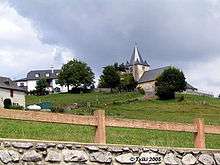
_%C3%A9glise_et_cimeti%C3%A8re_avec_st%C3%A8les_basques.JPG) The church of Alçabéhéty | |
.svg.png) Coat of arms | |
Location of Alçay-Alçabéhéty-Sunharette 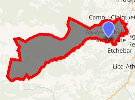
| |
 Alçay-Alçabéhéty-Sunharette  Alçay-Alçabéhéty-Sunharette | |
| Coordinates: 43°05′46″N 0°54′27″W | |
| Country | France |
| Region | Nouvelle-Aquitaine |
| Department | Pyrénées-Atlantiques |
| Arrondissement | Oloron-Sainte-Marie |
| Canton | Montagne Basque |
| Intercommunality | Pays Basque |
| Government | |
| • Mayor (2014-2020) | Anicet Erreçarret |
| Area 1 | 34.40 km2 (13.28 sq mi) |
| Population (2017-01-01)[1] | 226 |
| • Density | 6.6/km2 (17/sq mi) |
| Time zone | UTC+01:00 (CET) |
| • Summer (DST) | UTC+02:00 (CEST) |
| INSEE/Postal code | 64015 /64470 |
| Elevation | 217–1,535 m (712–5,036 ft) (avg. 344 m or 1,129 ft) |
| 1 French Land Register data, which excludes lakes, ponds, glaciers > 1 km2 (0.386 sq mi or 247 acres) and river estuaries. | |
Geography
Location
Alçay-Alçabéhéty-Sunharette is located in the former province of Soule. It is located some 35 km west by south-west of Oloron-Sainte-Marie and 10 km north of Larrau.
Access
The commune can be accessed by the small D247 road from the village to Tardets-Sorholus in the north-east. The D149 branches off this road in the commune and goes north to Camou-Cihigue. There is also the D117 road which goes west from the village to Mendive.[2]
Hydrography
Located in the drainage basin of the Adour, most of the southern border of the commune is formed by the Alphoura river (18 km long) which also flows through the village and continues northeast to join the Saison near Alos-Sibas-Abense. The Alphoura is fed by many tributaries rising in the commune including the Azaléguy and Ardounc. The Escalérako erreka rises in the south and flows west with its many tributaries.[2]
Paul Raymond[3] mentioned the Arangaïxa, a brook that rises at Alçay and flows into the Alphoura.
Localities and hamlets[4]
- Aguer (Barn)
- Albinzé (cayolar)
- Alçabéhéty
- Alçay
- Ampo
- Andoche (cayolar)
- Arangaitz (Pass)
- Arhansus (cayolar)
- Arhex Borde
- Atheis
- Azaléguy
- Azaléguiko Karbia (Cave)
- Bagadoya
- Bagazaguita (cayolar)
- Bagothusta
- Belhy
- Berrayde
- Bethalia
- Bidalunia
- Bordagagna
- Borda Iribarneko
- Bordapia
- Burdin Olatzé (cayolar)
- Burgance
- Çaro
- Chaldupia
- Chuburu
- Croix Garat (la)
- Elichabeborda
- Eltzegagnia (cayolar)
- Erbinia
- Espoulapia
- Esquirassy (district)[5][6]
- Etcheberri Borda
- Etcheverry[3]
- Etchecopar Borda
- Eyhéraber
- Ezpalako Larria
- Goyheneix Borde
- Gutux Borde
- Habrague (cayolar)
- Handia (Borda)
- Haquits (Mill)
- Harizmendy
- Harristolatzia
- Houretaborda
- Ibarburia (Pass)
- Ibarria
- Illaberria
- Inharchoury
- Irriko Borda
- Kamitchel
- Kharalda
- Lapistoy
- Larramendia
- Laxunia
- Laze
- Lechardoy
- Lecharria (cayolar)
- Lekayborda
- Leziague (fountain)
- Lomendi
- Luchiloa
- Lucu
- Lutogagne
- Maraizolatzé
- Méthola
- Miranda
- Néquézaurborda
- Ourdanberhartia
- Oxapuria
- Oxibar (Pass)
- Pista Uthurria
- Poyuko Borda
- Sallaberriko borda
- Sobieta (Grange)
- Sunharette
- Thipinka
- Ursoy (cayolar)
- Utzidoy
- Uztarila (cayolar)
- Uztubulia
Neighbouring communes and villages[2] | ||||||||||
|---|---|---|---|---|---|---|---|---|---|---|
| ||||||||||
Toponymy
_%C3%A9glise_et_cimeti%C3%A8re_avec_st%C3%A8les_basques.JPG)
_vieilles_steles_basques.JPG)
_l'%C3%A9glise.JPG)
The commune name in Basque is Altzai-Altzabeheti-Zunharreta.[7]
According to Jean-Baptiste Orpustan, the base (h)altz meaning "aulne" was used for the both toponyms Alcay and Alçabéhéty. beheti means "at the bottom".[8]
The name Sunharette comes from the Basque zunhar (Name from Soule meaning "elm" or "poplar") using the romanized locative suffix ette meaning the "place of elm".[8]
The following table details the origins of the commune name and other names in the commune.
| Name | Spelling | Date | Source | Page | Origin | Description |
|---|---|---|---|---|---|---|
| Alçay | Aucet Suson | 1337 | Orpustan | Village | ||
| Alsay | 1385 | Raymond | Duchesne | |||
| Ausset-Suson | 1479 | Raymond | Ohix | |||
| Alçay | 1520 | Orpustan | ||||
| Aucet Suson | 1690 | Orpustan | ||||
| Auset Suson | 1690 | Orpustan | ||||
| Alsai | 17th century | Raymond | Chronicles | |||
| Alçabéhéty | Aucet Juson | 1337 | Orpustan | Village | ||
| Ausec-Juson | 1385 | Raymond | Duchesne | |||
| Auset Juzon | 1385 | Orpustan | ||||
| Auzat Juzon | 1385 | Orpustan | ||||
| Aucet Juzon | 1690 | Orpustan | ||||
| Alcabehety | 1793 | Cassini1 | ||||
| Alçabehety | 1801 | Cassini1 | Bulletin des lois | |||
| Sunharette | Sunarte | 1337 | Orpustan | Village | ||
| Sunharrete | 1475 | Raymond | Ohix | |||
| Sunharrette | 1690 | Orpustan | ||||
| Sunarrette | 1690 | Orpustan | ||||
| Sonharette | 1793 | Cassini2 | ||||
| Sunharrette | 1801 | Cassini2 | Bulletin des lois | |||
| Arangaïxa | L'Arangaïxa | 1863 | Raymond | Stream | ||
| Arhansus | Arhansus | 1863 | Raymond | Wood | ||
| Athaguy | Athagui | 1520 | Raymond | Soule | Farm | |
| Atagui | 1520 | Raymond | Soule | |||
| Belhy | Belhy | 1863 | Raymond | Mountain | ||
| Burunolatxé | Le Col de Burunolatxé | 1863 | Raymond | Pass | ||
| Couhourre | Couhourre | 1863 | Raymond | Wood | ||
| Esquirassy | Esquirassy | 1863 | Raymond | Mountain | ||
| Etcheverry | Etcheberri | 17th century | Raymond | Chronicles | Fief, under the Viscounts of Soule | |
| Handiague | Handiague | 1863 | Raymond | Mountain |
Sources:
- Orpustan: Jean-Baptiste Orpustan, New Basque Toponymy[8]
- Raymond: Topographic Dictionary of the Department of Basses-Pyrenees, 1863, on the page numbers indicated in the table. (in French)[3]
- Cassini1: Alçabéhéty on the Ldh/EHESS/Cassini database[9]
- Cassini2: Sunharette on the Ldh/EHESS/Cassini database[10]
Origins:
History
In 1790 Sunharette was the chief town of a canton which was part of the District of Mauleon. The canton included the communes of Alçay-Alçabéhéty-Sunharette, Alos-Sibas-Abense, Camou-Cihigue, Etchebar, Lacarry-Arhan-Charritte-de-Haut, Lichans-Sunhar, and Ossas-Suhare.
In 1833, the three communes of Alçay, Alçabéhéty, and Sunharette merged to form a single joint commune.
Heraldry
Arms of Alçay-Alçabéhéty-Sunharette |
Blazon: Azure, a wolf argent passant at dexter in front of a beehive of Or to sinister and accompanied by 6 bees at dexter chief, 3 bees at sinister chief, one bee at sinister, and 4 bees in base the same.[15] |
Administration
List of Successive Mayors[16]
| From | To | Name | Party | Position |
|---|---|---|---|---|
| 1983 | 2001 | Arnaud Dascon | ||
| 2001 | Present | Anicet Erreçarret |
(Not all data is known)
Inter-communality
The town is part of seven intercommunal organisations:
- the Community of communes of Soule-Xiberoa
- the association to support Basque culture;
- the SIVOM of the canton of Tardets;
- the intercommunal association of the gaves d'Oloron and Mauléon
- the SIVU for Tourism in Haute-Soule and Barétous;
- the AEP association for Soule Country
- the association for remediation of Soule Country
Population
| Historical population | ||
|---|---|---|
| Year | Pop. | ±% |
| 2005 | 233 | — |
| 2006 | 226 | −3.0% |
| 2007 | 219 | −3.1% |
| 2008 | 223 | +1.8% |
| 2009 | 228 | +2.2% |
| 2010 | 232 | +1.8% |
| 2011 | 231 | −0.4% |
| 2012 | 228 | −1.3% |
| 2013 | 227 | −0.4% |
| 2014 | 227 | +0.0% |
| 2015 | 226 | −0.4% |
| 2016 | 226 | +0.0% |
Economy
Activity is mainly focused on agriculture (livestock and pasture). The town is part of the Appellation d'origine contrôlée (AOC) zone of Ossau-iraty.
According to the 2006 classification of INSEE, showing the median household incomes for all communes with more than 50 households (30,687 communes out of the 36,681 communes identified)[17] Alçay-Alçabéhéty-Sunharette is ranked 20,901st with an average income of €14,927 per year.
Culture and heritage
Civil heritage
The commune has two sites that are registered as historical monuments:
- The Seven Ibarnaba Tumuli in the Esquirassy district

- The Ten Ibarletta Tumuli in the Esquirassy district
- Other sites of interest
Religious Heritage
- The Romanesque Parish Church of Saint-Pierre (Middle Ages)

Environmental heritage
- The Belhygagne peaks (also called the peak of Vultures) and Gaztelia are the highest points in the commune at, respectively, 1,072 and 1,345 metres high.[4]
See also
External links
- ALTZAI-ALTZABEHETI-ZUNHARRETA in the Bernardo Estornés Lasa - Auñamendi Encyclopedia (Euskomedia Fundazioa) (in Spanish)
- Alçay-Alçabéhéty-Sunharette on Lion1906
- Alçay-Alçabéhéty-Sunharette on Google Maps
- Alçay-Alçabéhéty-Sunharette on Géoportail, National Geographic Institute (IGN) website (in French)
- Sunharete and Alcabehety on the 1750 Cassini Map
- Alçay-Alçabéhéty-Sunharette on the INSEE website (in French)
- INSEE (in French)
Notes and references
Notes
References
- "Populations légales 2017". INSEE. Retrieved 6 January 2020.
- Google Maps
- Topographic Dictionary of the Department of Basses-Pyrenees, Paul Raymond, Imprimerie nationale, 1863, Digitised from Lyon Public Library 15 June 2011 (in French)
- Géoportail, IGN (in French)
- Ministry of Culture, Mérimée PA00084309 Seven Ibarnaba Tumuli (in French)
- Ministry of Culture, Mérimée PA00084308 Ten Ibarletta Tumuli (in French)
- Brigitte Jobbé-Duval, Dictionary of placenames - Pyrénées-Atlantiques, 2009, Archives and Culture, ISBN 978-2-35077-151-9 (in French)
- Jean-Baptiste Orpustan, New Basque Toponymy, Presses universitaires de Bordeaux, 2006, ISBN 2 86781 396 4 (in French)
- Alçabéhéty on the Ldh/EHESS/Cassini database (in French)
- Sunharette on the Ldh/EHESS/Cassini database (in French)
- Duchesne Collection, volumes 99 to 114, containing the papers of Oihenart, former Imperial Librarian - Bibliothèque nationale de France
- Manuscripts from the 15th century in the Departmental Archives of Pyrénées-Atlantiques (in French)
- Titles of the Arthez-Lassalle family at Tardets (in French)
- Custom of Soule in 1520, printed at Pau in 1760 (in French)
- Guy Ascarat Archived November 9, 2013, at the Wayback Machine
- List of Mayors of France
- Statistical Summary by commune, department, and employment sector Archived 2012-06-04 at Archive.today, INSEE website, consulted on 9 September 2009 (in French)
- Ministry of Culture, Mérimée IA64000703 Parish Church of Saint-Pierre (in French)
- Ministry of Culture, Palissy PM64000026 Processional Cross (in French)
| Wikimedia Commons has media related to Alçay-Alçabéhéty-Sunharette. |

| Authority control |
|
|---|