Aurions-Idernes
Aurions-Idernes is a commune in the Pyrénées-Atlantiques department in the Nouvelle-Aquitaine region of south-western France.
Aurions-Idernes | |
|---|---|
 A general view of Aurions-Idernes | |
Location of Aurions-Idernes 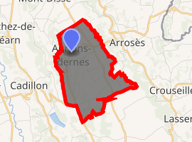
| |
 Aurions-Idernes  Aurions-Idernes | |
| Coordinates: 43°32′20″N 0°08′14″W | |
| Country | France |
| Region | Nouvelle-Aquitaine |
| Department | Pyrénées-Atlantiques |
| Arrondissement | Pau |
| Canton | Terres des Luys et Coteaux du Vic-Bilh |
| Intercommunality | Nord-Est Béarn |
| Government | |
| • Mayor (2014-2020) | Nadine Oulie |
| Area 1 | 6.32 km2 (2.44 sq mi) |
| Population (2017-01-01)[1] | 104 |
| • Density | 16/km2 (43/sq mi) |
| Time zone | UTC+01:00 (CET) |
| • Summer (DST) | UTC+02:00 (CEST) |
| INSEE/Postal code | 64079 /64350 |
| Elevation | 136–284 m (446–932 ft) (avg. 173 m or 568 ft) |
| 1 French Land Register data, which excludes lakes, ponds, glaciers > 1 km2 (0.386 sq mi or 247 acres) and river estuaries. | |
The inhabitants of the commune are known as Aurionais or Aurionaises.[2]
Geography
Aurions-Idernes is located some 50 km north by north-east of Pau and 12 km north-west of Maubourguet. Access to the commune is by the D205 road from Séméacq-Blachon in the south which passes through the length of the commune on the eastern side and continues north to join the D317. Access to the village is by the D219 road from Arrosès in the east which passes through the village and continues south-west to join the D13 near Cadillon. The commune is mainly farmland with some forested areas.[3]
The Larcis river forms most of the eastern border of the commune as it flows north to join the Lées east of Ségos. Several unnamed tributaries rise in the commune and flow east to join the Larcis.[3]
Places and Hamlets[4]
Neighbouring communes and villages[3]
Places adjacent to Aurions-Idernes | ||||||||||
|---|---|---|---|---|---|---|---|---|---|---|
| ||||||||||
Toponymy
The commune name in béarnais is Aurions-Idèrnas. Michel Grosclaude indicated that Aurions is probably from the Latin man's name Aurius with the suffix -onis giving "Domain of Aurius". The origin of the name Idernes however remains obscure.[8]
The following table details the origins of the commune name and other names in the commune.
| Name | Spelling | Date | Source | Page | Origin | Description |
|---|---|---|---|---|---|---|
| Aurions | Ryons | 1227 | Raymond | Marca | Village | |
| Aurios | 1385 | Raymond | Census | |||
| Riontz | 1538 | Raymond | Reformation | |||
| Aurious | 1750 | Cassini | ||||
| Idernes | Ydernes | 1385 | Raymond | Census | Village | |
| Ydernas | 1540 | Raymond | Reformation | |||
| Idernes | 1750 | Cassini | ||||
| L'Abbat | L'Abbat | 1863 | Raymond | Moor | ||
| Les Barsious | Les Barsious | 1863 | Raymond | Moor | ||
| Cailhabet | Cailhabet | 1863 | Raymond | Farm | ||
| Castéra | Castéra | 1863 | Raymond | Place | ||
| Disse | Düsse | 1487 | Raymond | Establishments | Hamlet | |
| Dissa | 1538 | Raymond | Reformation | |||
| Dyssa | 1546 | Raymond | Reformation | |||
| L'Enclos | L'Enclos | 1863 | Raymond | Hamlet | ||
| Serramone | Serramona | 1538 | Raymond | Reformation | Fief | |
| Sarramonne | 1675 | Raymond | Reformation | |||
| Sarramoune | 1780 | Raymond | Aurions |
Sources:
- Raymond: Topographic Dictionary of the Department of Basses-Pyrenees, 1863, on the page numbers indicated in the table. (in French)[5]
- Grosclaude: Toponymic Dictionary of communes, Béarn, 2006 (in French)[8]
- Cassini: Cassini Map from 1750[9]
Origins:
History
Paul Raymond noted on page 17 of the 1863 dictionary that in 1385 Aurions and Idernes depended on the bailiwick of Lembeye and respectively had 11 and 13 fires.[5]
Idernes was merged with Aurions in 1844. In 1846 the commune, which had been part of the Canton of Garlin, changed to be part of the Canton of Lembeye.
Administration
List of Successive Mayors[15]
| From | To | Name | Party | Position |
|---|---|---|---|---|
| 1995 | 2008 | André Lagrave | ||
| 2008 | 2020 | Nadine Oulie |
(Not all data is known)
Inter-communality
The commune is part of five inter-communal structures:
- the Community of communes of Lembeye en Vic-Bilh;
- the SIVU for Highways in the Canton of Lembeye;
- the SIVU for the educational grouping of Aurions-Idernes, Arrosès, Séméacq-Blachon, and Moncaup;
- the Energy association of Pyrénées-Atlantiques;
- the inter-communal association for the management of drinking water (SIAEP) of Vic-Bilh Montanérès;
Demography
In 2010 the commune had 110 inhabitants. The evolution of the number of inhabitants is known from the population censuses conducted in the commune since 1793. From the 21st century, a census of communes with fewer than 10,000 inhabitants is held every five years, unlike larger towns that have a sample survey every year.[Note 1]
| 1793 | 1800 | 1806 | 1821 | 1831 | 1836 | 1841 | 1846 | 1851 |
|---|---|---|---|---|---|---|---|---|
| 204 | 239 | 251 | 205 | 275 | 302 | 432 | 451 | 407 |
| 1856 | 1861 | 1866 | 1872 | 1876 | 1881 | 1886 | 1891 | 1896 |
|---|---|---|---|---|---|---|---|---|
| 406 | 391 | 343 | 331 | 306 | 286 | 284 | 262 | 273 |
| 1901 | 1906 | 1911 | 1921 | 1926 | 1931 | 1936 | 1946 | 1954 |
|---|---|---|---|---|---|---|---|---|
| 236 | 223 | 228 | 191 | 201 | 191 | 189 | 175 | 175 |
| 1962 | 1968 | 1975 | 1982 | 1990 | 1999 | 2006 | 2010 | - |
|---|---|---|---|---|---|---|---|---|
| 169 | 174 | 144 | 157 | 141 | 117 | - | 110 | - |


Economy
The commune is part of the appellation d'origine contrôlée (AOC) zones of Madiran, Pacherenc-du-vic-bilh, and Béarn.
Culture and heritage
Civil heritage
The commune has a number of buildings and structures that are registered as historical monuments:
Religious heritage
The commune has several religious buildings and structures that are registered as historical monuments:
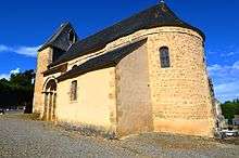
- The Parish Church of Saint Pierre of Aurions (12th century)

- A Wayside Cross (19th century)

- 2 tablecloths for the choir enclosure (19th century)
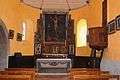
- A Pulpit (18th century)
- An Altar, altar seating, Tabernacle, and a statue (19th century)
- 4 Altar candlesticks (19th century)
- A Painting: Christ on the Cross with the Virgin (19th century)
- A Retable (18th century)
- A Tabernacle (18th century)
- Altar seating (18th century)
- The Main Altar with seating, Tabernacle, Retable, and 4 candlesticks (18th century)
- The Main Altar (19th century)
- A Wayside Cross (19th century)
- Church Picture Gallery
 Church of Saint Pierre interior
 Stained Glass in the Church
 Stained Glass in the Church
Facilities
The commune has a nursery school.
See also
External links
- Aurions-Idernes on Lion1906
- Aurions-Idernes on Géoportail, National Geographic Institute (IGN) website (in French)
- Aurious and Jderne on the 1750 Cassini Map
- Aurions-Idernes on the INSEE website (in French)
Notes and references
Notes
- At the beginning of the 21st century, the methods of identification have been modified by Law No. 2002-276 of 27 February 2002 Archived 6 March 2016 at the Wayback Machine, the so-called "law of local democracy" and in particular Title V "census operations" allows, after a transitional period running from 2004 to 2008, the annual publication of the legal population of the different French administrative districts. For communes with a population greater than 10,000 inhabitants, a sample survey is conducted annually, the entire territory of these communes is taken into account at the end of the period of five years. The first "legal population" after 1999 under this new law came into force on 1 January 2009 and was based on the census of 2006.
References
- "Populations légales 2017". INSEE. Retrieved 6 January 2020.
- Inhabitants of Pyrénées-Atlantiques (in French)
- Google Maps
- Géoportail, IGN (in French)
- Topographic Dictionary of the Department of Basses-Pyrenees, Paul Raymond, Imprimerie nationale, 1863, Digitised from Lyon Public Library 15 June 2011 (in French)
- Ministry of Culture, Mérimée IA00026453 Fortified Buildings at Aurions-Basious (in French)
- Ministry of Culture, Mérimée IA00026452 Fortified Buildings at Aurions-le-Tétour (in French)
- Michel Grosclaude, Toponymic Dictionary of communes, Béarn, Edicions reclams & Édition Cairn - 2006, 416 pages, ISBN 2-35068-005-3 (in French)
- Cassini Map 1750 - Asson
- Pierre de Marca, History of Béarn
- Manuscript from the 14th century - Departmental Archives of Pyrénées-Atlantiques (in French)
- Manuscript from the 16th to 18th centuries - Departmental Archives of Pyrénées-Atlantiques (in French)
- Manuscripts from the 15th and 16th centuries in the Departmental Archives of Pyrénées-Atlantiques (in French)
- Manuscript from the 18th century in the Departmental Archives of Pyrénées-Atlantiques (in French)
- List of Mayors of France (in French)
- Ministry of Culture, Mérimée IA00027300 Houses and Farms (in French)
- Ministry of Culture, Mérimée PA00084326 Church of Saint Pierre of Aurions (in French)
- Ministry of Culture, Mérimée IA00026451 Parish Church of Saint Pierre (in French)
- Ministry of Culture, Palissy IM64002141 Wayside Cross (in French)
- Ministry of Culture, Palissy IM64002140 2 tablecloths for the choir enclosure (in French)
- Ministry of Culture, Palissy IM64002139 Pulpit (in French)
- Ministry of Culture, Palissy IM64002138 Altar, altar seating, Tabernacle, and a statue (in French)
- Ministry of Culture, Palissy IM64002137 4 Altar candlesticks (in French)
- Ministry of Culture, Palissy IM64002136 Painting: Christ on the Cross with the Virgin (in French)
- Ministry of Culture, Palissy IM64002135 Retable (in French)
- Ministry of Culture, Palissy IM64002134 Tabernacle (in French)
- Ministry of Culture, Palissy IM64002133 Altar seating (in French)
- Ministry of Culture, Palissy IM64002132 Main Altar with seating, Tabernacle, Retable, and 4 candlesticks (in French)
- Ministry of Culture, Palissy IM64002131 Main Altar (in French)
| Wikimedia Commons has media related to Aurions-Idernes. |
| Authority control |
|
|---|