Baliracq-Maumusson
Baliracq-Maumusson is a commune of the Pyrénées-Atlantiques department in the Nouvelle-Aquitaine region of south-western France.
Baliracq-Maumusson | |
|---|---|
 Entry to Baliracq | |
Location of Baliracq-Maumusson 
| |
 Baliracq-Maumusson  Baliracq-Maumusson | |
| Coordinates: 43°32′48″N 0°15′14″W | |
| Country | France |
| Region | Nouvelle-Aquitaine |
| Department | Pyrénées-Atlantiques |
| Arrondissement | Pau |
| Canton | Terres des Luys et Coteaux du Vic-Bilh |
| Intercommunality | Canton de Garlin |
| Government | |
| • Mayor (2014–2020) | Sylvain Sergent |
| Area 1 | 6.06 km2 (2.34 sq mi) |
| Population (2017-01-01)[1] | 122 |
| • Density | 20/km2 (52/sq mi) |
| Time zone | UTC+01:00 (CET) |
| • Summer (DST) | UTC+02:00 (CEST) |
| INSEE/Postal code | 64090 /64330 |
| Elevation | 120–224 m (394–735 ft) (avg. 132 m or 433 ft) |
| 1 French Land Register data, which excludes lakes, ponds, glaciers > 1 km2 (0.386 sq mi or 247 acres) and river estuaries. | |
The inhabitants of the commune are known as Baliracois or Baliracoises.[2]
Geography
Baliracq-Maumusson is located some 45 km east by north-east of Orthez and 20 km south of Aire-sur-l'Adour. Access to the commune is by the D211 road from Lannecaube in the south which passes through the length of the commune along the eastern side to join the D41 just north of the commune. Access to the village of Baliracq is by Le Moulin road branching from the D211. The commune is mixed forest and farmland.[3]
The Lées river forms the eastern border of the commune as it flows north to join the Adour near Aire-sur-l'Adour. The Gabassot forms the northern border of the commune as it flows east into the Lées. Two other streams rise in the commune and flow into the Lées.[3]
Places and hamlets[4]
Neighbouring communes and villages[3]
Places adjacent to Baliracq-Maumusson | ||||||||||
|---|---|---|---|---|---|---|---|---|---|---|
| ||||||||||
Toponymy
According to Michel Grosclaude the name Baliracq probably came from a Latin man's name Valerus with the Gallo-Roman suffix -acum giving the "Domain of Valerus". For Maumusson he proposed a Gascon man's name: the nickname mau meaning "bad" combined with mus meaning "nose" and the suffix -on giving "unfriendly" or "sullen".[11]
The following table details the origins of the commune name and other names in the commune.
| Name | Spelling | Date | Source | Page | Origin | Description |
|---|---|---|---|---|---|---|
| Baliracq | Saint-Félix de Balirac | 10th century | Raymond | Marca | Village | |
| Vallirag | 1100 | Grosclaude | ||||
| Valliracum | 1100 | Grosclaude | ||||
| Balirag | 1443 | Raymond | Carresse | |||
| Baliracq | 1750 | Cassini | ||||
| Balirac | 1801 | Ldh/EHESS/Cassini | Bulletin des lois | |||
| Balirac | 1863 | Raymond | ||||
| Maumusson | Maumusson | 1750 | Cassini | Village | ||
| Maumussou | 1774 | Raymond | Terrier | |||
| Castéra | Casterar | 1542 | Raymond | Reformation | Farm |
Sources:
- Raymond: Topographic Dictionary of the Department of Basses-Pyrenees, 1863, on the page numbers indicated in the table. (in French)[12]
- Grosclaude: Toponymic Dictionary of communes, Béarn, 2006 (in French)[11]
- Cassini: Cassini Map from 1750[13]
- Ldh/EHESS/Cassini: Ldh/EHESS/Cassini database (in French)
Origins:
- Marca: Pierre de Marca, History of Béarn.[14]
- Carresse:[15]
- Terrier: Terrier of Baliracq, E 177
- Reformation: Reformation of Béarn[16]
History
Paul Raymond noted on page 20 of his 1863 dictionary that Baliracq was a vassal of the Viscounts of Béarn.
The communes of Baliracq and Maumusson were merged in 1828.
Administration
| From | To | Name |
|---|---|---|
| 1792 | 1795 | Jean Sansot |
| 1792 | 1796 | Pierre Sartou |
| 1795 | 1797 | Jean Sarraille |
| 1796 | 1797 | Jacques Monsegu-Castera |
| 1797 | 1798 | Raymond Peyroutel |
| 1797 | 1798 | Pierre Sartou |
| 1798 | 1803 | Jean Sarraille |
| 1798 | 1799 | Pierre Miqueu |
| 1799 | 1805 | Pierre Boucahort |
| 1803 | 1826 | Germain Florence |
| 1805 | 1808 | Pascal Florence |
| 1808 | 1809 | Jean Borie |
| 1809 | 1811 | Jean Manaud |
| 1811 | 1812 | Jean Borie |
| 1812 | 1813 | Fils Lescriba |
| 1813 | 1817 | Jean Borie |
| 1817 | 1821 | Jean Manaud |
| 1821 | 1835 | Jean Fils Manaud |
| 1835 | 1837 | Jean Pierre Sarthou |
| 1837 | 1840 | Adrien Alexandre de Malden |
| 1841 | 1848 | Jean Manaud |
| 1848 | 1882 | Henry Croedey |
| 1882 | 1888 | Pierre Mirande |
| 1888 | 1894 | Jean Sansous |
| 1894 | 1896 | Bernard Castet |
| 1896 | 1900 | Jean Sansous |
| 1900 | 1925 | Charles Sansous |
| 1925 | 1929 | Jacques Cassoulong |
| 1929 | 1933 | Max Croedey |

- Mayors from 1933
| From | To | Name | Party | Position |
|---|---|---|---|---|
| 1933 | 1944 | Jacques Cassoulong | ||
| 1944 | 1944 | Charles Honoré | ||
| 1944 | 1947 | Jean Barreyat | ||
| 1947 | 1989 | Albert Sansous | ||
| 1989 | 2014 | Yvan Duviau | ||
| 2014 | 2020 | Sylvain Sergent |
(Not all data is known)
Inter-communality
The commune is part of six inter-communal structures:
- the Community of communes of the Canton of Garlin;
- the SIVU for roads in the Garlin region;
- the SIVU for the Lées and its tributaries;
- the Energy association of Pyrénées-Atlantiques;
- the inter-communal association for the supply of drinking water for Luy-Gabas-Lées;
- the inter-communal association of Five Rivers;
Demography
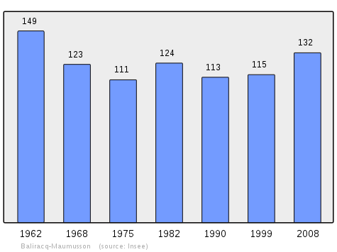
In 2010 the commune had 145 inhabitants. The evolution of the number of inhabitants is known from the population censuses conducted in the commune since 1793. From the 21st century, a census of communes with fewer than 10,000 inhabitants is held every five years, unlike larger communes that have a sample survey every year.[Note 1]
| 1793 | 1800 | 1806 | 1821 | 1831 | 1836 | 1841 | 1846 | 1851 |
|---|---|---|---|---|---|---|---|---|
| 281 | 314 | 342 | 364 | 410 | 405 | 386 | 411 | 401 |
| 1856 | 1861 | 1866 | 1872 | 1876 | 1881 | 1886 | 1891 | 1896 |
|---|---|---|---|---|---|---|---|---|
| 368 | 341 | 335 | 325 | 323 | 309 | 303 | 267 | 248 |
| 1901 | 1906 | 1911 | 1921 | 1926 | 1931 | 1936 | 1946 | 1954 |
|---|---|---|---|---|---|---|---|---|
| 231 | 256 | 217 | 196 | 188 | 184 | 198 | 183 | 174 |
| 1962 | 1968 | 1975 | 1982 | 1990 | 1999 | 2006 | 2010 | - |
|---|---|---|---|---|---|---|---|---|
| 149 | 123 | 111 | 124 | 113 | 115 | 118 | 145 | - |
Culture and heritage
Civil heritage
The commune has a number of buildings and structures that are registered as historical monuments:
- A Mill at Baliracq (1764)

- A Farmhouse at Baliracq-Bouquehort (19th century)
- The Coussié House at Maumusson-Tardan (1742)
- The Castéra House at Baliracq-Castéra (1742)
- The Lafon House at Maumusson-Crédey (17th century)
- The Sansot House at Maumusson-Sansot (19th century)
- The Chateau de Milly at Maumusson-Florence (18th century)
- Houses and Farms (18th-19th century)
- A Fortified Area (Middle Ages)
- A Fortified Complex (Prehistoric).
Religious heritage

The Parish Church of Saint Peter (11th century)![]()
- An Altar, Tabernacle, and Statue (19th century)

- 2 Statues: Saints Felix and Peter (18th century)
- A Tabernacle (17th century)
- An Altar Painting: Remission of the keys to Saint Peter (19th century)
- An Altar and Retable (1844)
- Wood Panelling (1844)
- A Wayside Cross (19th century)
- An Altar Vase (20th century)
- A Monstrance (18th century)
- An Altar Candlestick (19th century)
- 6 Altar Candlesticks (18th century)
- A Thurible
- A Celebrant's Chair (18th century)
- A Stoup (1822)
- A Pulpit (18th century)
- A Confessional (18th century)
- The Choir Enclosure (1840)
See also
External links
- Baliracq-Maumusson on Lion1906
- Baliracq-Maumusson on Google Maps
- Baliracq-Maumusson on Géoportail, National Geographic Institute (IGN) website (in French)
- Baliracq and Maumußon on the 1750 Cassini Map
- Baliracq-Maumusson on the INSEE website (in French)
- INSEE (in French)
Notes and references
Notes
- At the beginning of the 21st century, the methods of identification have been modified by Law No. 2002-276 of 27 February 2002 Archived 6 March 2016 at the Wayback Machine, the so-called "law of local democracy" and in particular Title V "census operations" allows, after a transitional period running from 2004 to 2008, the annual publication of the legal population of the different French administrative districts. For communes with a population greater than 10,000 inhabitants, a sample survey is conducted annually, the entire territory of these communes is taken into account at the end of the period of five years. The first "legal population" after 1999 under this new law came into force on 1 January 2009 and was based on the census of 2006.
References
- "Populations légales 2017". INSEE. Retrieved 6 January 2020.
- Inhabitants of Pyrénées-Atlantiques (in French)
- Google Maps
- Géoportail, IGN (in French)
- Ministry of Culture, Mérimée IA00026195 Farmhouse at Baliracq-Bouquehort (in French)
- Ministry of Culture, Mérimée IA00026193 Castéra House at Baliracq-Castéra (in French)
- Ministry of Culture, Mérimée IA00026192 Lafon House at Maumusson-Crédey (in French)
- Ministry of Culture, Mérimée IA00026190 Chateau de Milly at Maumusson-Florence (in French)
- Ministry of Culture, Mérimée IA00026191 Sansot House at Maumusson-Sansot (in French)
- Ministry of Culture, Mérimée IA00026194 Coussié House at Maumusson-Tardan (in French)
- Michel Grosclaude, Toponymic Dictionary of communes, Béarn, Edicions reclams & Édition Cairn - 2006, 416 pages, p. 99 & 106, ISBN 2-35068-005-3(in French)
- Topographic Dictionary of the Department of Basses-Pyrenees, Paul Raymond, Imprimerie nationale, 1863, Digitised from Lyon Public Library 15 June 2011 (in French)
- Cassini Map 1750 – Baliracq-Maumusson
- Pierre de Marca, Histoire de Bearn, La Veuve Jean Camusat, 1640, 850 pages (in French)
- Contracts retained by Carresse, Notary of Béarn, Manuscripts from the 15th century in the Departmental Archives of Pyrénées-Atlantiques (in French)
- Manuscript from the 16th to 18th centuries - Departmental Archives of Pyrénées-Atlantiques (in French)
- List of Mayors of France (in French)
- Ministry of Culture, Mérimée IA00027435 Mill at Baliracq (in French)
- Ministry of Culture, Mérimée IA00026189 Houses and Farms (in French)
- Ministry of Culture, Mérimée IA00026188 Fortified Area (in French)
- Ministry of Culture, Mérimée IA00026187 Fortified Complex (in French)
- Ministry of Culture, Mérimée IA00026196 Parish Church of Saint Peter (in French)
- Ministry of Culture, Palissy IM64001601 Altar, Tabernacle, and Statue (in French)
- Ministry of Culture, Palissy IM64001600 2 Statues: Saints Felix and Peter (in French)
- Ministry of Culture, Palissy IM64001599 Tabernacle (in French)
- Ministry of Culture, Palissy IM64001598 Altar Painting: Remission of the keys to Saint Peter (in French)
- Ministry of Culture, Palissy IM64001597 Altar and Retable (in French)
- Ministry of Culture, Palissy IM64001596 Wood Panelling (in French)
- Ministry of Culture, Palissy IM64001584 Wayside Cross (in French)
- Ministry of Culture, Palissy IM64001583 Altar Vase (in French)
- Ministry of Culture, Palissy IM64001582 Monstrance (in French)
- Ministry of Culture, Palissy IM64001581 Altar Candlestick (in French)
- Ministry of Culture, Palissy IM64001580 6 Altar Candlesticks (in French)
- Ministry of Culture, Palissy IM64001579 Thurible (in French)
- Ministry of Culture, Palissy IM64001578 Celebrant's Chair (in French)
- Ministry of Culture, Palissy IM64001577 Stoup (in French)
- Ministry of Culture, Palissy IM64001576 Pulpit (in French)
- Ministry of Culture, Palissy IM64001575 Confessional (in French)
- Ministry of Culture, Palissy IM64001574 Choir Enclosure (in French)
| Wikimedia Commons has media related to Baliracq-Maumusson. |
| Authority control |
|
|---|