Aydius
Aydius is a commune in the Pyrénées-Atlantiques department in the Nouvelle-Aquitaine region of south-western France.
Aydius | |
|---|---|
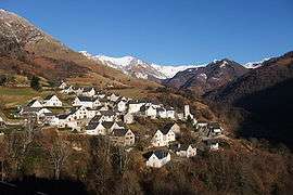 A general view of Aydius | |
Location of Aydius 
| |
 Aydius  Aydius | |
| Coordinates: 43°00′07″N 0°32′24″W | |
| Country | France |
| Region | Nouvelle-Aquitaine |
| Department | Pyrénées-Atlantiques |
| Arrondissement | Oloron-Sainte-Marie |
| Canton | Oloron-Sainte-Marie-1 |
| Intercommunality | Haut Béarn |
| Government | |
| • Mayor (2014-2020) | Bernard Choy |
| Area 1 | 34.72 km2 (13.41 sq mi) |
| Population (2017-01-01)[1] | 114 |
| • Density | 3.3/km2 (8.5/sq mi) |
| Time zone | UTC+01:00 (CET) |
| • Summer (DST) | UTC+02:00 (CEST) |
| INSEE/Postal code | 64085 /64490 |
| Elevation | 551–2,173 m (1,808–7,129 ft) |
| 1 French Land Register data, which excludes lakes, ponds, glaciers > 1 km2 (0.386 sq mi or 247 acres) and river estuaries. | |
Geography
Aydius is located some 25 km south by south-east of Oloron-Sainte-Marie just east of Bedous. Access to the commune is by the D237 road from Bedous which goes to the village and terminates there. The commune is alpine in nature with extensive forests, rugged terrain and snow-capped mountains in the east.[2]
The Gabarret river rises in the east of the commune and flows west gathering a large number of tributaries including the Ruisseau d'Arces, the Ruisseau du Saslars, the Gave de Béranfueil, the Gave de Bouren, the Ruisseau d'Ilhiec, the Ruisseau Sarité, the Ruisseau de Traillère, and the Ruisseau de Sahun (which forms part of the western border of the commune) before flowing west to join the Gave d'Aspe at Bedous.
Places and Hamlets
- Anire[3]
- L’Ardoisière
- Arès (barn)
- Arques (forest)[3]
- Las Arretortes (Cap de)
- Les Arrouyes[3]
- Baich (Rangole de)
- Barca[3]
- Barrada
- Bat (barn)
- Bat (bridge)
- Bérangueil
- Bérie (bank)
- Bérouste (Serrot de)
- Bésur (cabin)
- Bouren[3]
- Cachiquet (cabin)
- Calhabets (Pas de)
- Capdarest
- Capdevielle
- Capouret
- Carn de Haut (bank)
- Casaubon
- Les Catiasses (forest)
- Chechit
- Core de Cam
- Cot de Picars (alley)
- La Courade (Col de)
- Courdé
- Courrège Longue
- Cret Arrouy (Cap de)
- Escarrebirats (Pas d’)
- Escourau (bank)
- Escut (forest)
- Guérègne
- Haut (Rangole de)
- Hourquet Roes (cabin)
- Les Ichantes[3][4]
- Ichantes (forest)
- Illes (bank)
- Le Labay
- Lacazette
- Lacazotte
- Laresse
- Lartigalot
- Latoussé (Pènes des)
- Lespy
- Luc (barn)
- Manautton
- Mariebère (forest)[3]
- Mirande
- Mousquaté (forest)[3]
- Mousté (Col de)[3]
- Pée Nouqué (ruins)
- Pouey
- La Poueye (Hosse de)
- Salaneuve (ruins)
- Les Salars[3]
- Sarrelangue
- Sartiat (forest)
- Sézy (barn)
- Soumaous (Hosse de)
- Tousset
- l’Usclat (forest)[3]
Toponymy
The commune name in Gascon is Aidius. Michel Grosclaude said that the name probably comes from the same root as Aydie but its origin and meaning remain obscure.[5]
The following table details the origins of the commune name and other names in the commune.
| Name | Spelling | Date | Source | Page | Origin | Description |
|---|---|---|---|---|---|---|
| Aydius | Aydius | 1385 | Grosclaude | Village | ||
| Lo temple de Sent Martin d'Aydius | 1590 | Raymond | Register of Aydius, BB, i, folio 3 | |||
| Aydius | 1750 | Cassini | ||||
| Anire | Amire | 1385 | Raymond | Census | Farm | |
| Anire | 1863 | Raymond | ||||
| Le Col des Arques | Le Col des Arques | 1863 | Raymond | Pass from Aydius to Gère-Bélesten | ||
| Les Arrouyes | Les Arrouyes | 1863 | Raymond | Mountain | ||
| Barca | Barca | 1863 | Raymond | Mountain | ||
| Le Béranguet | Le Béranguet | 1863 | Raymond | Stream | ||
| Le Bouren | Le Bouren | 1863 | Raymond | Stream | ||
| Les Ichantes | Les Ichantes | 1863 | Raymond | Hamlet | ||
| L’Illecq | L’Illecq | 1863 | Raymond | Stream | ||
| Les Jaupins | Les Jaupins | 1863 | Raymond | Hamlet | ||
| Mariebère | Marie-Bère | 1863 | Raymond | Mountain[6] | ||
| Bois de Mousquaté | Mousquété | 1863 | Raymond | Forest | ||
| Mousté | Mousté | 1863 | Raymond | Mountain on the border with Sarrance | ||
| Col de Pian | Le Col de Pian | 1863 | Raymond | Pass to Bedous | ||
| Col de Picas | Le Col de Picas | 1863 | Raymond | Mountain Pass | ||
| Salars | Les Salars | 1863 | Raymond | Hamlet |
Sources:
- Grosclaude: Toponymic Dictionary of communes, Béarn, 2006 (in French)[5]
- Raymond: Topographic Dictionary of the Department of Basses-Pyrenees, 1863, on the page numbers indicated in the table. (in French)[3]
- Cassini: Cassini Map from 1750[7]
Origins:
- Census: Census of Béarn[8]
History
A rock shelter dating from prehistory called Abri Gandon-Lassus![]()
Paul Raymond noted on page 18 of his 1863 dictionary that the commune had a Lay Abbey, vassal of the Viscounts of Béarn and that in 1385 there were 30 fires and Aydius depended on the bailiwick of Aspe.[3]
Administration
List of Successive Mayors[10]
| From | To | Name | Party | Position |
|---|---|---|---|---|
| 1995 | 2014 | Bernard Bourguinat | ||
| 2014 | 2020 | Bernard Choy |
(Not all data is known)
Inter-communality
The commune is part of four inter-communal structures:
- the Community of communes of Vallée d'Aspe;
- the Energy association of Pyrénées-Atlantiques;
- the inter-communal association for aid to education in the Vallée d'Aspe;
- the joint association for Haut-Béarn.
Demography
In 2010 the commune had 100 inhabitants. The evolution of the number of inhabitants is known from the population censuses conducted in the commune since 1793. From the 21st century, a census of communes with fewer than 10,000 inhabitants is held every five years, unlike larger communes that have a sample survey every year.[Note 1]
| 1793 | 1800 | 1806 | 1821 | 1831 | 1836 | 1841 | 1846 | 1851 |
|---|---|---|---|---|---|---|---|---|
| 685 | 726 | 701 | 891 | 847 | 822 | 833 | 890 | 813 |
| 1856 | 1861 | 1866 | 1872 | 1876 | 1881 | 1886 | 1891 | 1896 |
|---|---|---|---|---|---|---|---|---|
| 855 | 735 | 695 | 715 | 694 | 613 | 586 | 541 | 526 |
| 1901 | 1906 | 1911 | 1921 | 1926 | 1931 | 1936 | 1946 | 1954 |
|---|---|---|---|---|---|---|---|---|
| 520 | 518 | 489 | 349 | 283 | 268 | 241 | 181 | 137 |
| 1962 | 1968 | 1975 | 1982 | 1990 | 1999 | 2006 | 2010 | - |
|---|---|---|---|---|---|---|---|---|
| 98 | 88 | 94 | 67 | 74 | 80 | 100 | 100 | - |

Economy
The economy of the commune is mainly focused towards agriculture and livestock. The commune is part of the Appellation d'origine contrôlée (AOC) zone of Ossau-iraty.
Culture and heritage
Civil heritage
The commune has many sites that are registered as historical monuments:
Religious heritage
Environmental heritage
Aydie contains a number of high mountains:
- The Sommet de Tachat (1,408 metres),
- The Sommet de Talabot (1,591 metres),
- The Sommet de Pétraube (1,606 metres,
- The Sommet de Houndarete (1,695 metres),
- The Soum de la Mousquère (1,778 metres,
- The Turon de la Goaita (1,805 metres,
- The Lousquette de Barca (1,870 metres,
- The Pic de Lariou (1,903 metres, and
- The Mailh Bassibe (1,973 metres.
Notable people linked to the commune
- Pierre Loustaunau, a General in India
See also
Bibliography
In his book L'ours et les brebis (The Bear and the sheep), Etienne Lamazou recounted his life as a transhumant shepherd from 1913 to 1969. Originally from Aydius, he never left except to take his cattle to their winter plain. He recounted the life of a shepherd as it still existed at the beginning of the 20th century. All the action takes place in and around Aydius and the book has many thousands of anecdotes sometimes soothing, sometimes moving, and often instructive.
Notes
- At the beginning of the 21st century, the methods of identification have been modified by Law No. 2002-276 of 27 February 2002 Archived 6 March 2016 at the Wayback Machine, the so-called "law of local democracy" and in particular Title V "census operations" allows, after a transitional period running from 2004 to 2008, the annual publication of the legal population of the different French administrative districts. For communes with a population greater than 10,000 inhabitants, a sample survey is conducted annually, the entire territory of these communes is taken into account at the end of the period of five years. The first "legal population" after 1999 under this new law came into force on 1 January 2009 and was based on the census of 2006.
References
- "Populations légales 2017". INSEE. Retrieved 6 January 2020.
- Google Maps
- Topographic Dictionary of the Department of Basses-Pyrenees, Paul Raymond, Imprimerie nationale, 1863, Digitised from Lyon Public Library 15 June 2011 (in French)
- Ministry of Culture, Mérimée PA64000002 Maison Ichante (in French)
- Michel Grosclaude, Toponymic Dictionary of communes, Béarn, Edicions reclams & Édition Cairn - 2006, 416 pages, ISBN 2-35068-005-3 (in French)
- from Maria beroy, meaning "Beautiful Mary": Robert Aymard (member of the French Onomastic Society), Pyrénéen Toponyms, Lacour, 2009 ISBN 9782750424305, page 251 (in French)
- Cassini Map 1750 – Aydius
- Manuscript from the 14th century - Departmental Archives of Pyrénées-Atlantiques (in French)
- Ministry of Culture, Mérimée PA64000012 Abri Gandon-Lassus Prehistoric Cave (in French)
- List of Mayors of France (in French)
- Ministry of Culture, Mérimée IA64001004 Maison Guiraudé (in French)
- Ministry of Culture, Mérimée IA64001007 Maison Pualet (in French)
- Ministry of Culture, Mérimée IA64001008 Maison Hontas (in French)
- Ministry of Culture, Mérimée IA64000980 Maison Ichante (in French)
- Ministry of Culture, Mérimée IA64001005 Maison Casaubon (in French)
- Ministry of Culture, Mérimée IA64000975 Parish Church of Saint Martin (in French)
- Ministry of Culture, Mérimée PA00132935 Parish Church of Saint Martin (in French)
External links
| Wikimedia Commons has media related to Aydius. |
| Authority control |
|
|---|