Altglienicke
Altglienicke is a locality (Ortsteil) of Berlin in the borought (Bezirk) of Treptow-Köpenick. Until 2001 it was part of the former borough of Treptow.
Altglienicke | |
|---|---|
Quarter of Berlin | |
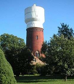 Water tower | |
Location of Altglienicke in Treptow-Köpenick and Berlin 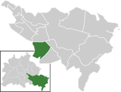 | |
 Altglienicke  Altglienicke | |
| Coordinates: 52°25′00″N 13°32′00″E | |
| Country | Germany |
| State | Berlin |
| City | Berlin |
| Borough | Treptow-Köpenick |
| Founded | 1375 |
| Subdivisions | 1 zone |
| Area | |
| • Total | 7.89 km2 (3.05 sq mi) |
| Elevation | 34 m (112 ft) |
| Population (2008-06-30) | |
| • Total | 26,101 |
| • Density | 3,300/km2 (8,600/sq mi) |
| Time zone | CET/CEST (UTC+1/+2) |
| Postal codes | (nr. 0906) 12524 |
| Vehicle registration | B |
| Website | Official website |
History
The village of Glinik was first mentioned in 1375. The Berlin Wall cut through Altglienicke (in East Berlin) and Rudow (in West Berlin) from 1961 until 1990. It was also the location for a joint American and British intelligence operation.
Geography
Position
The locality is situated in the south-western side of Treptow-Köpenick. It borders with Rudow (in Neukölln), Johannisthal, Adlershof, Grünau, Bohnsdorf and the municipality of Schönefeld, in the Dahme-Spreewald district of Brandenburg.
Subdivision
Altglienicke counts 1 zone (Ortslage):
- Falkenberg
Transportation
Altglienicke is served by the Berliner S-Bahn lines S45 and S9, with the stations of Altglienicke and Grünbergallee. Close to the locality is the Berlin Schönefeld Flughafen station, by the "Berlin Schönefeld" international airport.
See also
- Berlin Altglienicke railway station
External links
![]()
- (in German) Altglienicke official website
| |
| |