Dahme-Spreewald
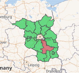
Dahme-Spreewald (Lower Sorbian: Wokrejs Damna-Błota) is a district in Brandenburg, Germany. It is bounded by (from the east and clockwise) the districts of Oder-Spree, Spree-Neiße, Oberspreewald-Lausitz, Elbe-Elster and Teltow-Fläming, and by the city of Berlin.
Dahme-Spreewald | |
|---|---|
| |
| Country | Germany |
| State | Brandenburg |
| Capital | Lübben |
| Area | |
| • Total | 2,261 km2 (873 sq mi) |
| Population (31 December 2018)[1] | |
| • Total | 169,067 |
| • Density | 75/km2 (190/sq mi) |
| Time zone | UTC+01:00 (CET) |
| • Summer (DST) | UTC+02:00 (CEST) |
| Vehicle registration | LDS |
| Website | dahme-spreewald.de |
History
The Spreewald region has always been a centre of Sorbian culture. In medieval times the cities of Lübben and Luckau had successively been capitals of the margravate of Lower Lusatia. From 1815 on Lower Lusatia was a part of Prussia. Throughout the 19th century the region remained an agriculturally used area, some urbanisation taking place in the very north (close to Berlin) only.
When the state of Brandenburg was newly founded in 1990, the districts of Lübben, Luckau and Königs Wusterhausen had been established. In 1993 the three districts were merged.
Geography
The Spree river enters the district in the southeast and leaves to the northeast. The wooded regions along its banks are called Spreewald. The Spreewald is the westernmost part of Lusatia. Especially the cities of Lübben and Lübbenau welcome many tourists each year, offering boat trips and relaxing holidays in the beautiful Spreewald nature.
The Dahme river is a tributary of the Spree. It forms many lakes in the northern part of the district. The Dahme leaves the district towards Berlin, where it is occasionally used for boat races. Eventually, it joins the Spree.
Demography
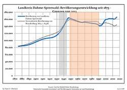 Development of Population since 1875 within the Current Boundaries (Blue Line: Population; Dotted Line: Comparison to Population Development of Brandenburg state)
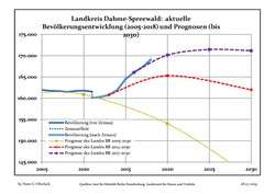 Recent Population Development and Projections (Population Development before Census 2011 (blue line); Recent Population Development according to the Census in Germany in 2011 (blue bordered line); Official projections for 2005-2030 (yellow line); for 2014-2030 (red line); for 2017-2030 (scarlet line)
| Landkreis Dahme-Spreewald: Population development within the current boundaries (2017)[2] | |||||||||||||||||||||||||||||||||||||||||||||||||||||||||||||||||||||||||||||||||||||||||||||||||||||||||||||||||||||||||||||||||||||||||
|---|---|---|---|---|---|---|---|---|---|---|---|---|---|---|---|---|---|---|---|---|---|---|---|---|---|---|---|---|---|---|---|---|---|---|---|---|---|---|---|---|---|---|---|---|---|---|---|---|---|---|---|---|---|---|---|---|---|---|---|---|---|---|---|---|---|---|---|---|---|---|---|---|---|---|---|---|---|---|---|---|---|---|---|---|---|---|---|---|---|---|---|---|---|---|---|---|---|---|---|---|---|---|---|---|---|---|---|---|---|---|---|---|---|---|---|---|---|---|---|---|---|---|---|---|---|---|---|---|---|---|---|---|---|---|---|---|---|
|
|
| |||||||||||||||||||||||||||||||||||||||||||||||||||||||||||||||||||||||||||||||||||||||||||||||||||||||||||||||||||||||||||||||||||||||
Coat of arms
 |
The coat of arms displays:
|
Towns and municipalities
| Amt-free towns | Ämter | |
|---|---|---|
|
|
|
3. Unterspreewald |
| 1seat of the Amt; 2town | ||
References
- "Bevölkerung im Land Brandenburg nach amtsfreien Gemeinden, Ämtern und Gemeinden 31. Dezember 2018". Amt für Statistik Berlin-Brandenburg (in German). July 2019.
- Detailed data sources are to be found in the Wikimedia Commons.Population Projection Brandenburg at Wikimedia Commons
External links
| Wikimedia Commons has media related to Dahme-Spreewald. |
- Official website (German)
- Spreewald tourist website (German)
- Spreewald Biosphere Reserve (German)
| Urban districts | |
|---|---|
| Rural districts | |
| Authority control |
|
|---|