Obrovac, Croatia
| Obrovac | |
|---|---|
| Town | |
 View of Obrovac | |
 Obrovac Location of Obrovac in Croatia | |
| Coordinates: 44°12′02″N 15°40′56″E / 44.2006°N 15.6822°E | |
| Country |
|
| County |
|
| Government | |
| • Mayor | Ante Župan (HDZ) |
| Population (2011)[1] | |
| • Town | 4,323 |
| • Urban | 985 |
| Time zone | UTC+1 (Central European Time) |
Obrovac (pronounced [ɔbrɔ̌ːʋats]) is a town located in northern Dalmatia, in the Zadar County of Croatia. The Obrovac municipality has a total population of 4,323 people. The town is located in the canyon of the river Zrmanja.
Demographics
The total population is 4,323, distributed in the following settlements:[1]
- Bilišane, population 176
- Bogatnik, population 131
- Golubić, population 132
- Gornji Karin, population 1,125
- Kaštel Žegarski, population 135
- Komazeci, population 42
- Krupa, population 127
- Kruševo, population 1,112
- Muškovci, population 100
- Nadvoda, population 170
- Obrovac, population 996
- Zelengrad, population 77
Geography
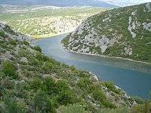
Obrovac is a town on the Zrmanja River some 11 km from the mouth of the river of the Novigrad sea. Above the town are the ruins of a fortified city. Its tributary Krupa attracts numerous day-trippers, and in recent times, rafting, canoe, and kayak lovers. Not far from the town of Krupa is a monastery with a valuable icon collection. About 2 km (1.24 mi) north-west of the town, along the road heading up to the mountains, lies a huge deserted industrial complex, an alumina plant built in the 1970s.
History

Obrovac first got its name in 1337. In 1527 Obrovac was taken over by the Ottoman Turks.
In October 1683, the population of Venetian Dalmatia, principally Uskoks of Ravni kotari, took arms and together with the rayah (lower class) of the Ottoman frontier regions rose up, taking Skradin, Karin, Vrana, Benkovac and Obrovac.[2] In 1687, Stojan Janković, a Morlach leader, forced the Ottomans out of Obrovac.
The municipality's population peaked at 13,498 in the 1971 census.[3] In the 1970s and 1980s, due to a low living standard in the area, Obrovac was significantly affected by emigration.[4]
According to the 1991 census, shortly before the start of Yugoslav Wars, 65.5% of population were Serbs.[5] During Operation Storm, the entire population of Obrovac fled before the Croatian Army entered the town on 5 August 1995, the second day of the operation.[6] The current ethnic majority are Croats with 65.7%, while 31.4% are Serbs.[7]
In 2008, Obrovac unveiled a restored riviera, which was the biggest financial investment in the city since Croatian independence.[8] In 2009, a mass grave from World War II was found in the area.[9]
People from Obrovac
- Janko Mitrović (1613–1659), Morlach army leader
- Stojan Janković (1636–1687), Morlach army leader
- Simeon Končarević (1690–1769), Serbian Orthodox bishop of Dalmatia and Albania
- Gerasim Zelić (1752–1828), Serbian Orthodox archimandrite and writer
- Dado Pršo's family
- Milan Pršo
- Arijan Komazec
- Obrad Zelić
References
- 1 2 "Population by Age and Sex, by Settlements, 2011 Census: Obrovac". Census of Population, Households and Dwellings 2011. Zagreb: Croatian Bureau of Statistics. December 2012.
- ↑ Radovan Samardžić (1990). Seobe srpskog naroda od XIV do XX veka: zbornik radova posvećen tristagodišnjici velike seobe Srba. Zavod za udžbenike i nastavna sredstva.
Становништво Млетачке Далмације, на првом месту Котарски ускоци, још у октобру 1683. дигло се на оружје заједно с рајом у пограничним крајевима Турске. Устаници су "сами заузели Скрадин, Карин, Врану, Бенковац и Обровац
- ↑ Graovac & Glamuzina 2002, p. 86.
- ↑ Graovac & Glamuzina 2002, p. 87.
- ↑ Graovac & Glamuzina 2002, p. 93.
- ↑ "Donosimo detalje akcije Oluja – tako se oslobađala domovina!". Večernji list (in Croatian). 4 August 2013. Retrieved 26 March 2015.
- ↑ "Population by Ethnicity, by Towns/Municipalities, 2011 Census: County of Zadar". Census of Population, Households and Dwellings 2011. Zagreb: Croatian Bureau of Statistics. December 2012.
- ↑ Kalmeta u Obrovcu otvorio obnovljenu rivu
- ↑ Stratišta iz Drugog svjetskog rata: tajne zakopane 60 godina, Slobodna Dalmacija
Sources
- Graovac, Vera; Glamuzina, Martin (June 2002). "Contemporary Dynamics and Population Structures of former Obrovac District" (PDF). Geoadria. 7 (1): 83–96. Retrieved 3 May 2017.
Further reading
- Conago, Josip (September 1928). "Sredovječne kule i gradine oko Novigrada i Karina" (PDF). Starohrvatska prosvjeta (in Croatian). II (1–2): 127–135. Retrieved 26 March 2015.
External links
| Wikimedia Commons has media related to Obrovac. |
Subdivisions of Zadar County | ||
|---|---|---|
| Cities and towns |  | |
| Municipalities | ||