Ordos City
| Ordos 鄂尔多斯市 • ᠣᠷᠳᠣᠰ ᠬᠣᠲᠠ | |
|---|---|
| Prefecture-level city | |
 Ulan Moron Site Lake in Ordos City | |
.svg.png) Location of Ordos City jurisdiction in Inner Mongolia (orange) | |
 Ordos Location of the city centre in Inner Mongolia | |
| Coordinates: 39°36′N 109°47′E / 39.600°N 109.783°ECoordinates: 39°36′N 109°47′E / 39.600°N 109.783°E | |
| Country | People's Republic of China |
| Region | Inner Mongolia |
| Municipal seat | Kangbashi District |
| Area | |
| • Prefecture-level city | 86,752 km2 (33,495 sq mi) |
| • Urban | 2,137 km2 (825 sq mi) |
| • Metro | 2,137 km2 (825 sq mi) |
| Elevation | 1,305 m (4,281 ft) |
| Highest elevation | 2,149 m (7,051 ft) |
| Lowest elevation | 850 m (2,790 ft) |
| Population (2014 est.) | |
| • Prefecture-level city | 2,035,653 |
| • Density | 23/km2 (61/sq mi) |
| • Urban | 582,544 |
| • Urban density | 270/km2 (710/sq mi) |
| • Metro | 582,544 |
| • Metro density | 270/km2 (710/sq mi) |
| Time zone | UTC+8 (China Standard) |
| Postal code | 017000 |
| ISO 3166 code | CN-NM-06 |
| GDP (2016) |
CNY 441.79 billion (US$ 66.51 billion) |
| GDP per capita (2016) |
CNY 215,486 (US$ 32,442) |
| Licence plate prefixes | 蒙K |
| Administrative division code | 150600 |
| Website |
www |
| Ordos City | |||||||||
| Chinese name | |||||||||
|---|---|---|---|---|---|---|---|---|---|
| Simplified Chinese | 鄂尔多斯 | ||||||||
| Traditional Chinese | 鄂爾多斯 | ||||||||
| |||||||||
| Mongolian name | |||||||||
| Mongolian Cyrillic | Ордос хот | ||||||||
| Mongolian script | ᠣᠷᠳᠣᠰ ᠬᠣᠲᠠ | ||||||||
| |||||||||
Ordos (![]()
![]()
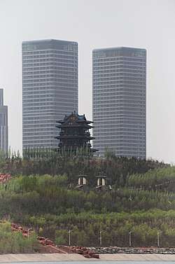
Ordos is known for its large scale government projects undertaken recently including most prominently the new Kangbashi District, an urban district planned as a massive civic mall with abundant monuments, cultural institutions, and other showpiece architecture. It was the venue for the 2012 Miss World Final.[1]
When it was newly built, the streets of the new Kangbashi district didn't have much activity and was frequently described as a "ghost city" by the western media. However by 2017, Kangbashi had become more populated with a resident population of 153,000 and around one-third of apartments occupied. In a Forbes article, Wade Shepard noted that "Of the 40,000 apartments that had been built in the new district since 2004, only 500 are still on the market.[2]
Etymology
The area had been administered under the Ih Ju League, also spelled Ikh Juu (Mongolian: ᠶᠡᠬᠡ ᠵᠤᠤ ᠠᠶᠢᠮᠠᠭ Yeke Juu ayimaγ; Chinese: 伊克昭盟; pinyin: Yīkèzhāo Méng) since the 17th century, and was redesignated a prefecture-level city and renamed to Ordos on 26 February 2001. "Ordos" means "palaces" in the Mongolian language.[3] Ordos originally referred to a tribe belonging to the Yeke Juu (Ike Chao ‘great monastery’) league and later included the tribe’s area, hence the Ordos, or Ordus, the area within the big bend of the Yellow River. Mongolian ordu(n), ord ‘court, residence of a ruler; palace; camp’, also for 'camp bodyguards'. According to Ramstedt -s is a plural suffix; further: ordu, orda; Turkic orta ‘a center’; Mongolian > Turkish orda ‘camp’ > Hindi urdū > English "horde."[4] The name is sometimes claimed to be related to the eight white yurts of Genghis Khan.[5] Linguistically, the Ordos dialect of Mongolian is quite different from neighboring Chakhar Mongolian.
Geography and climate
Ordos's prefectural administrative region occupies 86,752 square kilometres (33,495 sq mi) and covers the bigger part of the Ordos Desert, although the urban area itself is relatively small. It borders the prefecture-level divisions of Hohhot to the east, Baotou to the northeast, Bayan Nur to the north, Alxa League to the northwest, Wuhai to the west, the Ningxia Hui Autonomous Region to its southwest, and the provinces of Shaanxi and Shanxi to the south. The maximal north-south extent is 340 km (210 mi), while from east to west it stretches for 400 km (250 mi).[6]
The most populous municipality is Dongsheng which had a population of 582,544 inhabitants as of the 2010 census. Another urban area is the conglomeration of Kangbashi District and the adjacent township of Altan Xire.[7] Kangbashi is to the north of the Wulan Mulun River, a tributary of the Yellow River, while Altan Xire is to the south of the same river.
The area of Ordos Shi can roughly be divided into a hilly area in the east, high plateaus in the west and center, sandy deserts in the north and south, and plains at the southern bank of the Yellow River. The highest elevation, at 2,149 metres (7,051 ft), is located in the west, the lowest point, at 850 m (2,790 ft), is in the east.
There are two large deserts in the territory of Ordos Shi: Kubuqi Desert (库布其沙漠) in the north and the Maowusu Desert (毛乌素沙漠) in the south. The Kubuqi Desert occupies 19.2% of Ordos, or 16,600 km2 (6,400 sq mi), while the Maowusu Desert takes up 28.8% of the area, or 25,000 km2 (9,700 sq mi).
Ordos features a cold semi-arid climate (Köppen BSk), marked by long, cold and very dry winters; very warm, somewhat humid summers; and strong winds, especially in spring. The annual precipitation is 300 to 400 millimetres (11.8 to 15.7 in) in the eastern part of the city and 190 to 350 mm (7.5 to 13.8 in) in the western part. Most of the rain falls between July and September, with very little snow in winter; average annual evaporation reaches 2,000 to 3,000 mm (79 to 118 in). In the city proper, the monthly 24-hour average temperature ranges from −10.5 °C (13.1 °F) in January to 21.0 °C (69.8 °F) in July, while the annual mean is 6.16 °C (43.1 °F). Sunshine duration averages 2,700 to 3,200 hours annually.[6]
| Climate data for Ordos (1971−2000) | |||||||||||||
|---|---|---|---|---|---|---|---|---|---|---|---|---|---|
| Month | Jan | Feb | Mar | Apr | May | Jun | Jul | Aug | Sep | Oct | Nov | Dec | Year |
| Record high °C (°F) | 7.8 (46) |
13.9 (57) |
19.4 (66.9) |
32.2 (90) |
32.9 (91.2) |
32.2 (90) |
35.3 (95.5) |
33.3 (91.9) |
33.3 (91.9) |
24.4 (75.9) |
18.2 (64.8) |
10.6 (51.1) |
35.3 (95.5) |
| Average high °C (°F) | −4.8 (23.4) |
−1.3 (29.7) |
5.2 (41.4) |
14.1 (57.4) |
20.8 (69.4) |
25.0 (77) |
26.7 (80.1) |
24.5 (76.1) |
19.4 (66.9) |
12.6 (54.7) |
4.0 (39.2) |
−2.9 (26.8) |
11.9 (53.5) |
| Daily mean °C (°F) | −10.5 (13.1) |
−7.2 (19) |
−0.5 (31.1) |
7.7 (45.9) |
14.6 (58.3) |
19.1 (66.4) |
21.0 (69.8) |
19.1 (66.4) |
13.8 (56.8) |
6.8 (44.2) |
−1.7 (28.9) |
−8.3 (17.1) |
6.2 (43.1) |
| Average low °C (°F) | −14.7 (5.5) |
−11.5 (11.3) |
−5.4 (22.3) |
1.9 (35.4) |
8.4 (47.1) |
13.0 (55.4) |
15.8 (60.4) |
14.3 (57.7) |
8.8 (47.8) |
2.1 (35.8) |
−5.9 (21.4) |
−12.3 (9.9) |
1.2 (34.2) |
| Record low °C (°F) | −28.4 (−19.1) |
−27.5 (−17.5) |
−22.8 (−9) |
−11.6 (11.1) |
−4.8 (23.4) |
1.7 (35.1) |
9.1 (48.4) |
4.3 (39.7) |
−2.1 (28.2) |
−13.6 (7.5) |
−21.8 (−7.2) |
−25.3 (−13.5) |
−28.4 (−19.1) |
| Average precipitation mm (inches) | 2.1 (0.083) |
4.4 (0.173) |
10.8 (0.425) |
11.4 (0.449) |
25.8 (1.016) |
44.8 (1.764) |
105.7 (4.161) |
105.5 (4.154) |
44.7 (1.76) |
19.4 (0.764) |
5.3 (0.209) |
1.3 (0.051) |
381.2 (15.009) |
| Average precipitation days (≥ 0.1 mm) | 2.1 | 2.9 | 4.3 | 3.4 | 5.9 | 8.7 | 12.2 | 11.9 | 8.1 | 4.4 | 2.6 | 1.9 | 68.4 |
| Source: Weather China[6] | |||||||||||||
Economy
Ordos is one the most prosperous regions of China when measured by GDP figures. With a nominal per-capita GDP of US$34,352 and ppp per capita GDP of $65,192 in 2016, it ranks first among prefecture-level divisions in the entire Chinese mainland, and second in the PRC (including Hong Kong & Macau), behind Macau (Nominal GDP per capita: US$67,079; GDP (PPP) per capita: $96,148). It is extremely rich in natural resources, having one sixth of the national coal reserves. The pillars of its economy are textiles (wool), coal mining, petrochemicals, electricity generation, production of building materials, and bitcoin mining. An industrial park in Dalad Banner is home to one of the world's largest bitcoin 'mines' - really a massive server farm - owned by Beijing-based Bitmain.[8]
Administrative subdivisions
Ordos Shi is divided into two districts and seven banners:
| Map | |||||||
|---|---|---|---|---|---|---|---|
| Name | Mongolian | Hanzi | Hanyu Pinyin | Population (2010) | Area (km²) | Density (/km²) | |
| Dongsheng District | ᠳ᠋ᠦᠩᠱᠧᠩ ᠲᠣᠭᠣᠷᠢᠭ (Düŋšėŋ toɣoriɣ) |
东胜区 | Dōngshèng Qū | 582,544 | 2,146 | 271 | |
| Kangbashi District (Hia'bagx District) |
ᠬᠢᠶᠠ ᠪᠠᠭᠰᠢ ᠲᠣᠭᠣᠷᠢᠭ (Kiy-a baγsi toɣoriɣ) |
康巴什区 | Kāngbāshí Qū | 153,000 | 372.55 | 404 | |
| Dalad Banner | ᠳᠠᠯᠠᠳ ᠬᠣᠰᠢᠭᠤ (Dalad qosiɣu) |
达拉特旗 | Dálātè Qí | 322,101 | 8,192 | 40 | |
| Jungar Banner | ᠵᠡᠭᠦᠨᠭᠠᠷ ᠬᠣᠰᠢᠭᠤ (Jegünɣar qosiɣu) |
准格尔旗 | Zhǔngé'ěr Qí | 356,501 | 7,535 | 36 | |
| Otog Front Banner (Otog Omnod Banner) |
ᠣᠲᠣᠭ ᠤᠨ ᠡᠮᠦᠨᠡᠳᠦ ᠬᠣᠰᠢᠭᠤ (Otoɣ-un Emünedü qosiɣu) |
鄂托克前旗 | Ètuōkè Qián Qí | 68,282 | 12,318 | 6 | |
| Otog Banner | ᠣᠲᠣᠭ ᠬᠣᠰᠢᠭᠤ (Otoɣ qosiɣu) |
鄂托克旗 | Ètuōkè Qí | 148,844 | 20,064 | 4 | |
| Hanggin Banner | ᠬᠠᠩᠭᠢᠨ ᠬᠣᠰᠢᠭᠤ (Qaŋɣin qosiɣu) |
杭锦旗 | Hángjǐn Qí | 111,102 | 18,903 | 7 | |
| Uxin Banner | ᠦᠦᠰᠢᠨ ᠬᠣᠰᠢᠭᠤ (Üüsin qosiɣu) |
乌审旗 | Wūshěn Qí | 124,527 | 11,645 | 9 | |
| Ejin Horo Banner | ᠡᠵᠢᠨ ᠬᠣᠷᠣᠭᠠ ᠬᠣᠰᠢᠭᠤ (Ejin Qoroɣ-a qosiɣu) |
伊金霍洛旗 | Yījīnhuòluò Qí | 226,752 | 5,958 | 23 | |

Kangbashi New Area
A large, sparsely inhabited urban real estate development has been constructed 25 km (16 mi) from Dongsheng District. Intended to house a million people, it remains mostly uninhabited.[9][10] Intended to have 300,000 residents by 2010, government figures stated it had 28,000.[11] It has been the subject of several speculative publication, including an illustrated feature series conducted by Al Jazeera in 2010.[12] The Daily Mail has documented Ordos/Kangbashi and try to facile expose urban developments in China. trend [13][14]
Ordos Museum

In 2011, a 49,400-square-meter museum, entitled Ordos Museum (Chinese: 鄂尔多斯博物馆), was opened in Kangbashi. The museum, designed by China-based architectural practice MAD Studio, focuses upon the history of the Ordos area, as well as on the culture and traditions of Inner Mongolia.[15]
Transportation
Travel within Ordos City is primarily made by car or bus, using the city's network roads. Two tolled expressways, the G18 Rongcheng–Wuhai Expressway and the G65 Baotou–Maoming Expressway, provide connections with other towns and cities including Dongsheng.
There are no direct rail lines to the city. The closest is the Baoshen Line in Dongsheng.
Ordos Airport is located in Ejin Horo Banner.
Demographics
In the 2000 census, there were 1,369,766 inhabitants:
| ethnic group | population | share |
|---|---|---|
| Han | 1,207,971 | 88.19% |
| Mongols | 155,845 | 11.38% |
| Manchu | 2,905 | 0.21% |
| Hui | 1,861 | 0.14% |
| Tibetans | 1,023 | 0.07% |
Many people came from the Shanxi province, 30 km (19 mi)south of this city.
See also
References
- ↑ Sheehan, Matt (5 April 2015). "Signs of Life In China's Gleaming 'Ghost City' Of Ordos". Huffington Post. Retrieved 17 July 2018.
- ↑ Shepard, Wade. "China's Most Infamous 'Ghost City' Is Rising From The Desert". Forbes. Retrieved 2018-08-24.
- ↑ "Archived copy". Archived from the original on 2009-11-22. Retrieved 2009-11-13. 市情概况
- ↑ G. John Ramstedt: Kalmückisches Wörterbuch, Helsinki, 1935, Suomalais-Ugrilainen Seura, and Ferdinand D. Lessing, ed.: Mongolian-English Dictionary, Bloomington, Ind., 1982, The Mongolia Society, Inc.
- ↑ W. R. Carles, "Problems in Exploration II. Ordos", in The Geographical Journal, Vol. 33, No. 6 (Jun., 1909), p. 669
- 1 2 3 Weather China
- ↑ Woodworth, Max David. Frontier Boomtown Urbanism: City Building in Ordos Municipality, Inner Mongolia Autonomous Region, 2001-2011 (PDF). p. 51.
- ↑ Wong, Joon Ian. "Photos: Inside one of the world's largest bitcoin mines". Quartz. Retrieved 31 August 2017.
- ↑ Time Photos of Ordos/Kangbashi, Time Photos Website 2011
- ↑ Gus Lubin (2011-06-13). "NEW SATELLITE PICTURES OF CHINA'S GHOST CITIES". Business Insider. Retrieved 2011-12-09.
- ↑ Barboza, David (2010-10-19). "A New Chinese City, With Everything but People". New York Times.
- ↑ "China's Ghost Town". AlJazeera. 10 November 2009. Retrieved 2010-12-21.
- ↑ The Ghost Towns of China...The Daily Telegraph 18 Dec 2010
- ↑ "Ordos: The biggest ghost town in China". BBC News. 2012-03-17.
- ↑ "Ordos Museum". WikiArchitectura. Retrieved 2017-01-25.
External links
| Wikivoyage has a travel guide for Ordos City. |
Inner Mongolia topics | |
|---|---|
| General | |
| Geography | |
| Education | |
| Culture | |
| Cuisine | |
| Visitor attractions | |
| |
Major cities along the Yellow River | ||
|---|---|---|
| Province-level subdivisions | Cities (from upper reaches to lower reaches) |  |
| Gansu | ||
| Ningxia | ||
| Inner Mongolia | ||
| Shanxi | ||
| Shaanxi | ||
| Henan | ||
| Shandong | ||
Major cities along the Pearl River · Major cities along the Yangtze River | ||