Winkel tripel projection
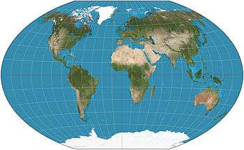
The Winkel tripel projection (Winkel III), a modified azimuthal map projection of the world, is one of three projections proposed by German cartographer Oswald Winkel (7 January 1874 – 18 July 1953) in 1921. The projection is the arithmetic mean of the equirectangular projection and the Aitoff projection:[1] The name Tripel (German for "triple") refers to Winkel's goal of minimizing three kinds of distortion: area, direction, and distance.[2]
Algorithm

where λ is the longitude minus that of the central meridian of the projection, φ is the latitude, φ1 is the standard parallel for the equirectangular projection, sinc is the unnormalized cardinal sine function (with the discontinuity removed), and

In his proposal, Winkel set:

A closed-form inverse mapping does not exist, and computing the inverse numerically is somewhat complicated.[3]
Comparison with other projections
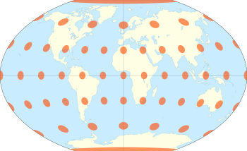
David M. Goldberg and J. Richard Gott III show that the Winkel tripel fares well against several other projections analyzed against their measures of distortion, producing small distance errors, small combinations of Tissot indicatrix ellipticity and area errors, and the smallest skewness of any of the projections they studied.[4] By a different metric, Capek's "Q", the Winkel tripel ranked ninth among a hundred map projections of the world, behind the common Eckert IV projection and Robinson projections.[5]
In 1998, the Winkel tripel projection replaced the Robinson projection as the standard projection for world maps made by the National Geographic Society.[2] Many educational institutes and textbooks followed National Geographic's example in adopting the projection, and most of those still use it.[6][7]
See also
References
- ↑ Snyder, John P. (1993). Flattening the Earth: Two Thousand Years of Map Projections. Chicago: University of Chicago Press. pp. 231–232. ISBN 0-226-76747-7. Retrieved 2011-11-14.
- 1 2 "Winkel Tripel Projections". Winkel.org. Retrieved 2011-11-14.
- ↑ Ipbüker, Cengizhan; Bildirici, I.Öztug (2002). "A General Algorithm for the Inverse Transformation of Map Projections Using Jacobian Matrices" (PDF). Proceedings of the Third International Symposium Mathematical & Computational Applications. Third International Symposium Mathematical & Computational Applications September 4–6, 2002. Konya, Turkey. Selcuk, Turkey. pp. 175–182. Archived from the original (PDF) on 20 October 2014.
- ↑ Goldberg, David M.; Gott III, J. Richard (2007). "Flexion and Skewness in Map Projections of the Earth" (PDF). Cartographica. 42 (4): 297–318. arXiv:astro-ph/0608501. doi:10.3138/carto.42.4.297. Retrieved 2011-11-14.
- ↑ Capek, Richard (2001). "Which is the best projection for the world map?" (DOC). Proceedings of the 20th International Cartographic Conference. Beijing, China. 5: 3084–93. Retrieved 2011-11-14.
- ↑ "NG Maps Print Collection – World Political Map (Bright Colored)". National Geographic Society. Retrieved 1 October 2013.
This latest world map ... features the Winkel Tripel projection to reduce the distortion of land masses as they near the poles.
- ↑ "Selecting a Map Projection – National Geographic Education". National Geographic Society. Retrieved 1 October 2013.
External links
| Wikimedia Commons has media related to Winkel tripel projection. |