Eckert IV projection
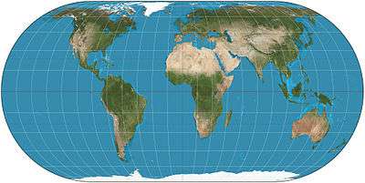
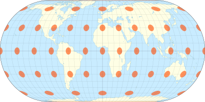
The Eckert IV projection is an equal-area pseudocylindrical map projection. The length of the polar lines is half that of the equator, and lines of longitude are semiellipses, or portions of ellipses. It was first described by Max Eckert in 1906 as one of a series of three pairs of pseudocylindrical projections. In each pair, the meridians have the same shape, and the odd-numbered projection has equally spaced parallels, whereas the even-numbered projection has parallels spaced to preserve area. The pair to Eckert IV is the Eckert III projection.[1]
Formulas
Forward formulae
Given a radius of sphere R, central meridian λ0 and a point with geographical latitude φ and longitude λ, plane coordinates x and y can be computed using the following formulas:
![{\displaystyle {\begin{aligned}x&={\frac {2}{\sqrt {4\pi +\pi ^{2}}}}R\,(\lambda -\lambda _{0})(1+\cos \theta )\approx 0.422\,2382\,R\,(\lambda -\lambda _{0})(1+\cos \theta ),\\[8pt]y&=2{\sqrt {\frac {\pi }{4+\pi }}}R\sin \theta \approx 1.326\,5004\,R\sin \theta ,\end{aligned}}}](../I/m/f23e7d33107851d02f860589a7fb5a4eee05f749.svg)
where

θ can be solved for numerically using Newton's method.[2]
Inverse formulae
![{\displaystyle {\begin{aligned}\theta &=\arcsin \left[y{\frac {\sqrt {4+\pi }}{2{\sqrt {\pi }}R}}\right]\approx \arcsin \left[{\frac {y}{1.326\,5004\,R}}\right]\\[8pt]\varphi &=\arcsin \left[{\frac {\theta +\sin \theta \cos \theta +2\sin \theta }{2+{\frac {\pi }{2}}}}\right]\\[8pt]\lambda &=\lambda _{0}+x{\frac {\sqrt {4\pi +\pi ^{2}}}{2R(1+\cos \theta )}}\approx \lambda _{0}+{\frac {x}{0.422\,2382\,R\,(1+\cos \theta )}}\end{aligned}}}](../I/m/4dc58f1e467ea9369202d3b0a67c7e3f2e8a9842.svg)
See also
References
- ↑ Snyder, John P.; Voxland, Philip M. (1989). An Album of Map Projections. Professional Paper 1453. Denver: USGS. p. 60. ISBN 978-0160033681. Retrieved 2014-09-27.
- ↑ Snyder, John P. (1987). Map Projections – A Working Manual. Professional Paper 1395. Denver: USGS. pp. 253–258. ISBN 0-226-76747-7. Retrieved 2013-07-24.
External links
| Wikimedia Commons has media related to Eckert IV projection. |