Equidistant conic projection
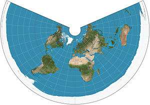
The world on an equidistant conic projection. 15° graticule, standard parallels of 20°N and 60°N.
The equidistant conic projection is a conic map projection known since Classical times, Ptolemy's first projection being derived from it.[1]
The projection has the useful property that distances along the meridians are proportionately correct, and distances are also correct along two standard parallels that the mapmaker has chosen. The two standard parallels are also free of distortion.
The map projection is used most often in maps of regions elongated east-to-west (such as the continental United States), with the standard parallels chosen to be about a sixth of the way inside the northern and southern limits of interest. This way distortion is minimized throughout the region of interest.
See also
References
External links
- Table of examples and properties of all common projections, from radicalcartography.net
This article is issued from
Wikipedia.
The text is licensed under Creative Commons - Attribution - Sharealike.
Additional terms may apply for the media files.