Werner projection
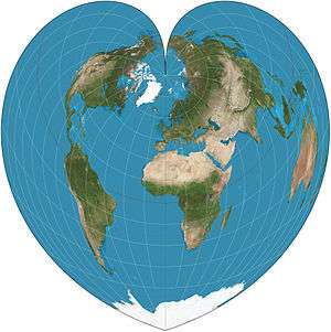
Werner projection of the world
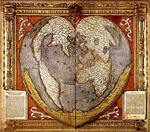
Werner projection of the world
The Werner projection is a pseudoconic equal-area map projection sometimes called the Stab-Werner or Stabius-Werner projection. Like other heart-shaped projections, it is also categorized as cordiform. Stab-Werner refers to two originators: Johannes Werner (1466–1528), a parish priest in Nuremberg, refined and promoted this projection that had been developed earlier by Johannes Stabius (Stab) of Vienna around 1500.
The projection is a limiting form of the Bonne projection, having its standard parallel at one of the poles (90°N/S).[1][2] Distances along each parallel and along the central meridian are correct, as are all distances from the north pole.
See also
References
- ↑ Snyder, John P (1993), Flattening the Earth: Two Thousand Years of Map Projections, pp. 60–2, ISBN 0-226-76747-7 .
- ↑ ———————— (1987), "Map Projections—A Working Manual", Professional Paper (1395), United States Geological Survey, pp. 138–0 .
External links

- Table of examples and properties of all common projections, Radical Cartography .
This article is issued from
Wikipedia.
The text is licensed under Creative Commons - Attribution - Sharealike.
Additional terms may apply for the media files.