General Perspective projection
The General Perspective projection is a map projection. When the Earth is photographed from space, the camera records the view as a perspective projection. When the camera is aimed toward the center of the Earth, the resulting projection is called Vertical Perspective. When aimed in other directions, the resulting projection is called a Tilted Perspective.
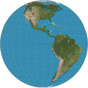
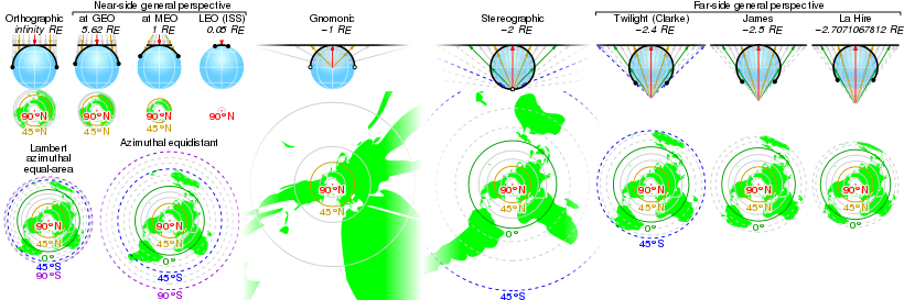
The Vertical Perspective is related to the stereographic projection, gnomonic projection, and orthographic projection. These are all true perspective projections, meaning that they result from viewing the globe from some vantage point. They are also azimuthal projections, meaning that the projection surface is a plane tangent to the sphere. This results in correct directions from the center to all other points. The point of perspective, or vantage point, for the General Perspective Projection is at a finite distance. It depicts the earth as it appears from some relatively short distance above the surface, typically a few hundred to a few tens of thousands of kilometers.
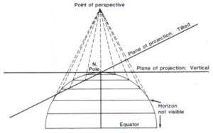
When tilted, the General Perspective projection is not azimuthal (see second figure below); directions are not true from the central point, and the projection plane is not tangent to the sphere. Tilted perspectives are common from aerial and low orbit photography, generally taken from at a height measured in kilometers to hundreds of kilometers, rather than the hundreds or thousands of kilometers typical of a vertical perspective.
Some forms of the projection were known to the Greeks and Egyptians 2,000 years ago. It was studied by several French and British scientists in the 18th and 19th centuries. However, the projection had little practical value at that time; computationally simpler nonperspective azimuthal projections could be used instead.
Space exploration led to a renewed interest in the perspective projection. Now the concern was for a pictorial view from space, not for minimal distortion. A picture taken with a hand-held camera from the window of a spacecraft has a tilted vertical perspective, so the manned Gemini and Apollo space missions sparked interest in this projection.
Some prominent Internet mapping tools also use the tilted perspective projection. For example, Google Earth and NASA World Wind show the globe as it appears from space. These applications permit a wide variety of interactive pan and zoom operations, including fly-through simulations, mimicking pictures or movies taken with a hand-held camera from an airplane or spacecraft.
See also