Equal Earth projection
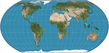
The Equal Earth map projection is an equal-area pseudocylindrical projection for world maps, invented by Bojan Šavrič, Bernhard Jenny, and Tom Patterson in 2018. It is inspired by the widely used Robinson projection, but unlike the Robinson projection, retains the relative size of areas. The projection equations are simple to implement and fast to evaluate.[1]
The projection is formulated as the polynomial equations

where

and refers to latitude and to longitude.


The features of the Equal Earth projection include:[2]
- The curved sides of the projection suggest the spherical form of Earth.
- Straight parallels make it easy to compare how far north or south places are from the equator.
- Meridians are evenly spaced along any line of latitude.
- Software for implementing the projection is easy to write and executes efficiently.
Development
The Equal Earth map projection was created by Bojan Šavrič, Tom Patterson, and Bernhard Jenny, as detailed in a 2018 publication for International Journal of Geographical Information Science.[1]
According to the creators:
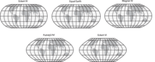
We created it to provide a visually pleasing alternative to the Gall–Peters projection, which some schools and organizations have adopted out of concern for fairness—they need a world map showing continents and countries at their true sizes relative to each other.[2]
Use
The first known thematic map published using the Equal Earth projection is a map of the global mean temperature anomaly for July 2018, produced by the NASA’s Goddard Institute for Space Studies.[3]
References
- 1 2 Šavrič, Bojan; Patterson, Tom; Jenny, Bernhard (2018-08-07). "The Equal Earth map projection". International Journal of Geographical Information Science: 1–12. doi:10.1080/13658816.2018.1504949.
- 1 2 "Equal Earth projection". shadedrelief.com. Retrieved 2018-08-23.
- ↑ "NASA GISS on Twitter". Twitter. Retrieved 2018-08-23.