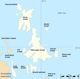
Whitsunday Island
 Hill Inlet, 2003 | |
 | |
| Geography | |
|---|---|
| Location | Coral Sea |
| Archipelago | Whitsunday Islands |
| Total islands | 74 |
| Area | 275.08 km2 (106.21 sq mi) |
| Administration | |
|
Australia | |
| State | Queensland |
| Local government area | Whitsunday Regional Council |
Whitsunday Island is the largest island in the Whitsunday group of islands located off the coast of Central Queensland, Australia. Whitehaven Beach was rated as the top Eco Friendly Beach in the world by CNN.com in July 2010.[1] The island should not be confused with Pinaki in the Tuamotu group which was named "Whitsunday Island" by Samuel Wallis in 1767. It is uninhabited today but was once settled by the sea-faring Ngaro people. The first of the logging camps on the island was set up by Eugene Fitzalan in 1861 to exploit the large hoop pine for construction of buildings on the mainland.[2]
Geography
The island is accessible by boat from the mainland tourist ports of Airlie Beach and Shute Harbour. It contains many popular destinations for both day visitors and overnight sailors, including the magnificent pure-white sands of Whitehaven Beach and Hill Inlet, the secure anchorage of Cid Harbour, and the sheltered waterway of Gulnare Inlet. The island also has six campgrounds.[3]
Named by Captain James Cook in early June 1770, the island covers 27,508 ha (275.08 km2) in area.[4] Around the northern bays of the island are seagrass beds which support a diverse range of marine life.[5] Unadorned rock-wallabies are found on the island.[5]
The seas here are warm, clear, shallow, nutrient rich and fast moving due to large tidal flows making them well-suited to the growth of fringing coral reefs.[6]
Gallery
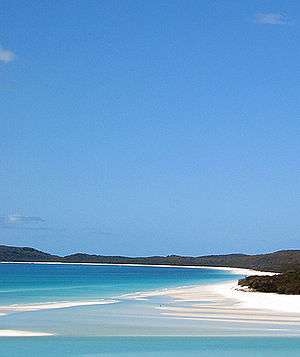 Whitehaven Beach
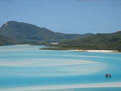 Hill inlet, north of Whitehaven Beach
 Panoramic view of Whitehaven Beach
See also
References
- ↑ "Qld beach wins world eco-friendly award". Sydney Morning Herald. Fairfax Media. 20 July 2010. Retrieved 28 July 2010.
- ↑ "The Government Contracts at Port Denison". The Courier. 12 October 1863.
- ↑ "Whitsunday Islands National Park - Camping information". Department of Environment and Resource Management. 21 June 2010. Archived from the original on 10 May 2010. Retrieved 28 July 2010.
- ↑ "Economics - Whitsunday Island". Australian Natural Resources Atlas. Department of the Environment, Water, Heritage and the Arts. Archived from the original on 2 April 2011. Retrieved 28 July 2010.
- 1 2 "Parks of the Whitsundays - Nature, culture and history". Department of Environment and Resource Management. 21 June 2010. Archived from the original on 9 May 2010. Retrieved 28 July 2010.
- ↑ "Whitsunday Islands: Nature, culture and history". Department of National Parks, Sport and Racing. 1 December 2014. Retrieved 6 February 2016.
External links