Oliver, British Columbia
| Oliver | |
|---|---|
| Town | |
| Town of Oliver[1] | |
 | |
| Motto(s): "Borne of the Waters, Blest by the Sun" | |
 Oliver Location of Oliver in British Columbia | |
| Coordinates: 49°10′58″N 119°33′5″W / 49.18278°N 119.55139°W | |
| Country |
|
| Province |
|
| Region | South Okanagan |
| Regional district | Okanagan-Similkameen |
| Village Incorporated | 1945 |
| Village Founded | 1918 |
| Town Incorporated | 1990 |
| Government | |
| • Governing body | Band Council, Town Council, RDOS Board |
| • Chief/Mayor/Director | C. Louie, R. Hovanes, A.Patton |
| Area | |
| • Town | 4.88 km2 (1.88 sq mi) |
| Elevation | 310 m (1,020 ft) |
| Population (2016)[2][3] | |
| • Town | 4,928 |
| • Density | 1,000/km2 (2,600/sq mi) |
| • Urban | 5,279 |
| Time zone | UTC-8 (PST) |
| Postal code | V0H 1T0 |
| Area code(s) | 250 / 778 / 236 |
| Highways |
|
| Waterways | Okanagan River |
| Website |
www |
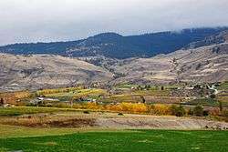
Oliver is a town near the south end of the Okanagan Valley in the Southern Interior of British Columbia, Canada, with a population of over 4,000 people. It is located between Osoyoos and Okanagan Falls, and is labeled as the Wine Capital of Canada by Tourism British Columbia.[4]
The community of Oliver is made up of land governed by three different bodies: the Town of Oliver, the Regional District of Okanagan-Similkameen and the Osoyoos Indian Band.
Local industries include grape and fruit production, agri-tourism, wine production, ranching, golfing and recreation, retail and service trades. Some of the largest employers include Osoyoos Indian Band, School District #53, Interior Health and Okanagan Tree Fruit Cooperative.
Origin of name
Named after John Oliver (1856–1927), Premier of British Columbia. "Honest John" and his government brought irrigation water and settlement lots to the area with the South Okanagan Lands Project.
History
The First Nations of the South Okanagan settled near the river, creeks and valley lakes. The first encroachment from the outside world came circa 1811, when fur traders came to the area with the establishment of Fort Okanagan (now in the US) and first explored the area for trade.
In the 1880s, free gold-bearing quartz was found at Camp McKinney (east of Oliver) which became a busy gold mine, attracting miners, con men, and outlaws. Fairview (just west of and above Oliver) miners found gold and fueled the growth of a boomtown but it lasted just a few years and no remnants of the town survive today, other than a heritage marker.
- Established in 1918, Oliver was a settlement for unemployed veterans of the First World War. A gravity-fed canal was constructed to provide irrigation to the semi-arid area.
- On January 30, 1919, the South Okanagan Lands Project (SOLP) began work on the Intake Dam at the base of McIntyre Bluff. Over the next eight years the 23 concrete-lined miles of the main canal were dug southward to the boundary. Eighteen and a half feet across the top, five feet deep and delivering 230 cubic feet per second, SOLP designed it to enable farmers to put nearly a foot of water per month on every acre of bottom land in the southern Valley. To get the canal from the east side of the Valley to the benches on the west, the “big siphon”—now concrete, but originally a 1,940-foot (590 m)-long wood-stave pipe of six and a half-foot-diameter—was constructed. It runs directly beneath the centre of Oliver. The offices of the land project and the building that housed the BC Police built circa 1924 stand today in Oliver as preserved heritage sites.
- A post office was established in 1921 and the BC government administered the area until 1945 when a village was incorporated and a council elected. In 1991, the community's municipal incorporation was upgraded to town, its current status.[5]
- In 1922 electrical power was brought to Oliver by the West Kootenay Power and Light Co.
- In 1923 the Kettle Valley Railway (CPR) constructed Oliver station and rails to transport fruit north to Penticton.
Administration of water
- SOLP (1919–1964) South Okanagan Lands Project – established by the Province of BC 1921 and run by provincial government employees for over forty years. In the spring of 1964 the Oliver/Osoyoos Fruit Growers' Association was informed that the province was getting out of the irrigation business.
- SOLID (1964–1989) South Okanagan Lands and Irrigation District – On June 25, 1964 the Fruit Growers' Association volunteered itself to be the cornerstone of the locally constituted South Okanagan Lands Irrigation District which operated the system until 1989.
- Oliver Water (1989 to present) Town of Oliver – The water district was divided into two parts to be run by municipal governments. The Towns of Oliver and Osoyoos now deliver nineteen billion imperial gallons—nearly one hundred billion litres—to the Valley’s parched soils annually. 1990 saw the election of Water Councillors in both communities—a first in BC.
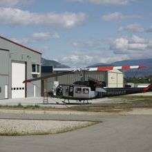
Airport
- CAU3 Paved Hard Surface 3200 ft by 50 ft
- Elevation: 1015 ft
- VFR - Lighted strip
- Owned by Town of Oliver
Coordinates:
- Lat 49-10.24 N
- Lon 119-33.04 W
- Home to Oliver Flying Club (terminal and hangars), Okanagan Kootenay Air Cadet Gliding Program, VMR Aviation, Transwest Helicopters, Oliver Fire Department, Oliver-Osoyoos Search and Rescue and Big Horn Squadron Royal Canadian Air Cadets
Demographics
Languages
According to the 2011 Census, 79.57% of Oliver's population have English as mother tongue; Punjabi is the mother tongue of 5.21% of the population, followed by German (2.87%), Portuguese (2.55%), French (2.45%), Spanish (0.96%), Dutch (0.74%), Hungarian (0.74%), Russian (0.53%), and Ukrainian (0.53%).[6]
| Mother tongue | Population | Percentage |
|---|---|---|
| English | 3,740 | 79.57% |
| Punjabi | 245 | 5.21% |
| German | 135 | 2.87% |
| Portuguese | 120 | 2.55% |
| French | 115 | 2.45% |
| Spanish | 45 | 0.96% |
| Dutch | 35 | 0.74% |
| Hungarian | 35 | 0.74% |
| Russian | 25 | 0.53% |
| Ukrainian | 25 | 0.53% |
Population
| Historical population | ||
|---|---|---|
| Year | Pop. | ±% |
| 1951 | 1,000 | — |
| 1956 | 1,147 | +14.7% |
| 1961 | 1,774 | +54.7% |
| 1966 | 1,563 | −11.9% |
| 1971 | 1,615 | +3.3% |
| 1976 | 1,641 | +1.6% |
| 1981 | 1,893 | +15.4% |
| 1986 | 1,963 | +3.7% |
| 1991 | 3,743 | +90.7% |
| 1996 | 4,285 | +14.5% |
| 2001 | 4,224 | −1.4% |
| 2006 | 4,370 | +3.5% |
| 2011 | 4,824 | +10.4% |
| 2016 | 4,928 | +2.2% |
| [7][8] | ||
- Town of Oliver: 4928
- Regional District Area 'C': 3473
- Osoyoos Indian Band: 900
Notable people
- John Anderson, Admiral (Ret) Former Chief of Defense Staff, graduate of SOHS
- Laslo Babits, Competed in javelin at the 1984 Summer Olympics in Los Angeles, California, finishing in 8th place. Graduate of SOSS
- Bill Barisoff, former Speaker of the British Columbia Legislative Assembly, graduate of SOSS
- George Bowering, First Canadian Poet Laureate, graduate of SOHS
- Patricia Smith Churchland, philosopher and neuroscientist, born in Oliver
- Ross Fitzpatrick, Canadian Senator (Okanagan-Similkameen), graduate of SOHS
- Clarence Louie, Chief of Osoyoos Indian Band, Order of BC
- Julie Skinner, 2002 Bronze Medal at Winter Olympics in Salt Lake City, Utah (Kelly Law team)
- Alison Smith, CBC TV anchor, graduate of SOSS
- Travis Turner, actor, lead role in the 2011 film Marley & Me: The Puppy Years
Climate
Oliver has a semi-arid climate (BSk) with hot, dry summers and cool winters.
| Climate data for Oliver, 1981–2010 normals, extremes 1924–present | |||||||||||||
|---|---|---|---|---|---|---|---|---|---|---|---|---|---|
| Month | Jan | Feb | Mar | Apr | May | Jun | Jul | Aug | Sep | Oct | Nov | Dec | Year |
| Record high °C (°F) | 16.0 (60.8) |
17.8 (64) |
23.0 (73.4) |
32.2 (90) |
37.8 (100) |
40.0 (104) |
43.9 (111) |
40.0 (104) |
38.3 (100.9) |
29.0 (84.2) |
20.0 (68) |
16.1 (61) |
43.9 (111) |
| Average high °C (°F) | 1.9 (35.4) |
5.5 (41.9) |
12.0 (53.6) |
17.4 (63.3) |
22.0 (71.6) |
25.8 (78.4) |
29.8 (85.6) |
29.6 (85.3) |
23.9 (75) |
15.6 (60.1) |
6.8 (44.2) |
1.5 (34.7) |
16.0 (60.8) |
| Daily mean °C (°F) | −0.8 (30.6) |
1.4 (34.5) |
6.2 (43.2) |
10.7 (51.3) |
15.1 (59.2) |
18.9 (66) |
22.2 (72) |
21.8 (71.2) |
16.4 (61.5) |
9.7 (49.5) |
3.3 (37.9) |
−1.1 (30) |
10.3 (50.5) |
| Average low °C (°F) | −3.4 (25.9) |
−2.7 (27.1) |
0.4 (32.7) |
3.9 (39) |
8.1 (46.6) |
11.9 (53.4) |
14.6 (58.3) |
13.8 (56.8) |
8.9 (48) |
3.7 (38.7) |
−0.2 (31.6) |
−3.8 (25.2) |
4.6 (40.3) |
| Record low °C (°F) | −26.7 (−16.1) |
−28.9 (−20) |
−17.8 (0) |
−9.4 (15.1) |
−2.2 (28) |
0.6 (33.1) |
3.9 (39) |
3.3 (37.9) |
−5.6 (21.9) |
−12.0 (10.4) |
−21.0 (−5.8) |
−26.1 (−15) |
−28.9 (−20) |
| Average precipitation mm (inches) | 28.7 (1.13) |
21.4 (0.843) |
24.9 (0.98) |
26.5 (1.043) |
34.7 (1.366) |
41.5 (1.634) |
25.5 (1.004) |
20.7 (0.815) |
18.7 (0.736) |
21.6 (0.85) |
31.2 (1.228) |
34.2 (1.346) |
329.7 (12.98) |
| Average rainfall mm (inches) | 13.7 (0.539) |
16.3 (0.642) |
23.2 (0.913) |
26.5 (1.043) |
34.7 (1.366) |
41.5 (1.634) |
25.5 (1.004) |
20.7 (0.815) |
18.7 (0.736) |
21.5 (0.846) |
25.9 (1.02) |
16.2 (0.638) |
284.5 (11.201) |
| Average snowfall cm (inches) | 15.0 (5.91) |
5.1 (2.01) |
1.7 (0.67) |
0.0 (0) |
0.0 (0) |
0.0 (0) |
0.0 (0) |
0.0 (0) |
0.0 (0) |
0.1 (0.04) |
5.3 (2.09) |
18.0 (7.09) |
45.2 (17.8) |
| Average precipitation days (≥ 0.2 mm) | 9.9 | 8.0 | 9.0 | 9.0 | 9.9 | 9.9 | 6.2 | 5.7 | 6.2 | 7.9 | 11.9 | 11.7 | 105.1 |
| Average rainy days (≥ 0.2 mm) | 5.5 | 6.6 | 8.5 | 9.0 | 9.9 | 9.9 | 6.2 | 5.7 | 6.2 | 7.8 | 10.4 | 5.3 | 90.9 |
| Average snowy days (≥ 0.2 cm) | 4.9 | 1.5 | 0.7 | 0.0 | 0.0 | 0.0 | 0.0 | 0.0 | 0.0 | 0.0 | 1.9 | 6.9 | 15.9 |
| Mean monthly sunshine hours | 42.7 | 83.4 | 141.3 | 191.6 | 239.7 | 238.6 | 282.7 | 274.5 | 211.9 | 147.5 | 64.4 | 41.4 | 1,959.6 |
| Percent possible sunshine | 15.8 | 29.2 | 38.4 | 46.6 | 50.6 | 49.2 | 57.8 | 61.5 | 55.9 | 44.0 | 23.3 | 16.1 | 40.7 |
| Source: Environment Canada[9] | |||||||||||||
References
- ↑ "British Columbia Regional Districts, Municipalities, Corporate Name, Date of Incorporation and Postal Address" (XLS). British Columbia Ministry of Communities, Sport and Cultural Development. Retrieved November 2, 2014.
- ↑ "2016 Census Profile". 2016 Census. Statistics Canada.
- ↑ Population and dwelling counts, for Canada, provinces and territories, and population centres, 2011 and 2006 censuses: British Columbia. Statistics Canada. Retrieved March 17, 2013
- ↑ Tourism BC website
- ↑ "Oliver". BC Geographical Names.
- ↑ Census Profile Oliver, T British Columbia http://www12.statcan.gc.ca/census-recensement/2011/dp-pd/prof/details/page.cfm?Lang=E&Geo1=CSD&Code1=5907014&Geo2=PR&Code2=01&Data=Count&SearchText=oliver&SearchType=Begins&SearchPR=01&B1=All&Custom=&TABID=1
- ↑ "Historical Municipal Census Data: 1921–2011". BC Stats. Retrieved August 25, 2013.
- ↑ http://www12.statcan.gc.ca/census-recensement/2016/dp-pd/prof/details/page.cfm?Lang=E&Geo1=CSD&Code1=5907014&Geo2=PR&Code2=59&Data=Count&SearchText=Oliver&SearchType=Begins&SearchPR=01&B1=All&TABID=1
- ↑ "OLIVER STP". 1981–2010 Canadian Climate Normals. Environment Canada. Retrieved 27 February 2017.
External links
| Wikimedia Commons has media related to Oliver, British Columbia. |

- Town of Oliver
- Osoyoos Indian Band
Municipalities and communities of Okanagan, British Columbia, Canada | ||
|---|---|---|
| Cities |  | |
| Towns | ||
| Districts | ||
| Villages | ||
| Designated places |
| |
| Unincorporated communities | ||
| Indian reservations | ||
| Ghost towns | ||
| Footnotes | ‡This populated place also has portions in an adjacent region | |