Regional District of Central Okanagan
| Central Okanagan Kelowna Metropolitan Area | |
|---|---|
| Regional district & Metropolitan area | |
| Regional District of Central Okanagan | |
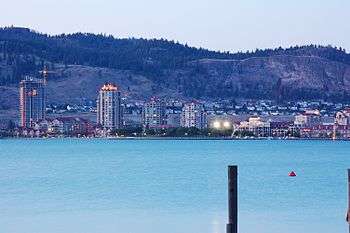 Downtown Kelowna from West Kelowna | |
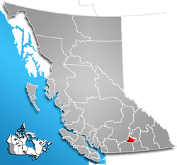 Location of Central Okanagan in British Columbia, Canada | |
| Country |
|
| Province |
|
| Head office location | Kelowna |
| Established | 1967 |
| Government | |
| • Type | Regional district |
| • Chair | Robert Hobson |
| • Vice Chair | Gail Given |
| Area[1] | |
| • Total | 2,904.86 km2 (1,121.57 sq mi) |
| Population (2011)[1] | |
| • Total | 179,839 |
| • Density | 61.9/km2 (160/sq mi) |
| Canadian CD rank: 30th | |
| Time zone | UTC-8 (PST) |
| Website | Regional District of Central Okanagan |
The Regional District of Central Okanagan (RDCO) is a regional district in the Canadian province of British Columbia, comprising the City of Kelowna, City of West Kelowna and their surrounding municipalities. The regional district's offices are located in Kelowna.
Statistics Canada defines the Kelowna CMA (Census Metropolitan Area) or Kelowna Metropolitan Area as being identical in area with the RDCO. The population in 2005 was 165,221, an increase from the official Canada 2006 Census total of 162,276 (these figures exclude the population of reserves belonging to the Westbank First Nation). The area is 2,904.86 square kilometres.
Communities
Incorporated municipalities
- Cities
- District municipalities
Communities and neighbourhoods
- Kelowna neighborhoods
- Belgo
- Benvoulin
- Black Mountain
- Braeloch
- Central City
- Clifton
- Crawford
- Dilworth
- Downtown
- East Kelowna
- Glenmore
- Kettle Valley
- KLO
- McKinley Landing
- Midtown
- Mission
- Pandosy
- Rutland
- Southeast Kelowna
- Southridge
- Quail Ridge
- District municipality villages
- Carr's Landing
- Casa Loma
- Ellison
- Glenrosa
- Lakeview Heights
- Okanagan Centre
- Oyama
- Rose Valley
- Shannon Lake
- Westbank
- Winfield
Regional district electoral areas
Central Okanagan West Electoral (Central Okanagan J)
Central Okanagan West Electoral Area used to be known as the Westside Electoral Area. It was created from the merger of Central Okanagan G and Central Okanagan H. The 2005 population. exclusive of anyone living on an Indian Reserve, was 37,638 people. In 2007 most of the electoral area's population transferred to the jurisdiction of the newly incorporated District Municipality of West Kelowna.
Communities
Central Okanagan West
- Beau Park
- Blue Grouse
- Brent Road
- Caesars Landing
- Cinnabar Estates
- Crystal Mountain
- Estamont
- Ewings Landing
- Fintry Delta
- Jenny Creek
- Killiney Beach
- La Casa Resort
- Lake Okanagan Resort
- Muirallen Estates
- Nahun
- Pine Point
- Secret Cove
- Shelters Cove
- Traders Cove
- Trepanier Bench
- Upper Fintry
- Valley of the Sun
- Wainman Cove
- Westshores Estates
- Wilson Landing
Indian reserves
(within the boundaries of, but not part of, the RD)
- Governed by the Okanagan Indian Band:
- Duck Lake 7 (N end Ellison Lake, just south of Winfield)
- Governed by the Westbank First Nation
- Tsinstikeptum 9 (in West Kelowna)
- Tsinstikeptum 10 (usually known as the Westbank Indian Reserve, in West Kelowna)
- Mission Creek 8 (Okanagan Mission)
- Medicine Creek 12, 10 km SE of Kelowna
- Medicine Hill 11, 15 km SE of Kelowna
References
External links
- Regional District of Central Okanagan
- School District No. 23 Central Okanagan
- Kelowna Regional Transit System
| Communities |
|
|---|---|
| Electoral areas | |
| Education | |
| Transportation | |
| |
| Subdivisions |  | |
|---|---|---|
| Communities | ||
| Metro areas and agglomerations | ||
| Regional districts |
| |
| ||
Coordinates: 49°53′17″N 119°29′44″W / 49.888028°N 119.495417°W