Osoyoos
| Osoyoos | |
|---|---|
| Town | |
| Town of Osoyoos[1] | |
 Town of Osoyoos | |
| Motto(s): Canada's warmest welcome[2] | |
 Osoyoos Location of Osoyoos in British Columbia | |
| Coordinates: 49°01′56″N 119°28′05″W / 49.03222°N 119.46806°W | |
| Country |
|
| Province |
|
| Region | South Okanagan/Boundary |
| Regional District | Okanagan-Similkameen |
| Incorporated | January 14, 1946 |
| Government | |
| • Mayor | Sue McKortoff |
| • Governing Body | Osoyoos Town Council |
| • MP | Richard Cannings |
| • MLA | Linda Larson |
| Area | |
| • Total | 8.76 km2 (3.38 sq mi) |
| Elevation | 283 m (928 ft) |
| Population (2016) | |
| • Total | 5,085 |
| • Density | 598.2/km2 (1,549/sq mi) |
| Time zone | UTC-8 (Pacific Time Zone) |
| • Summer (DST) | UTC-7 (Pacific Daylight Time) |
| Postal code span | V0H |
| Area code(s) | 250 / 778 / 236 |
| Highways |
|
| Website |
www |
Osoyoos (/ɒˈsuːjuːs/,[2] historically /ˈsuːjuːs/)[3] is the southern-most town in the Okanagan Valley in British Columbia between Penticton and Omak. Near the border with Washington state, the town is also adjacent to the Indian Reserve of the Osoyoos Indian Band.[3] The origin of the name Osoyoos was the word sẁiẁs (pronounced "soo-yoos") meaning "narrowing of the waters" in the local Okanagan language (Syilx'tsn). The "O-" prefix is not indigenous in origin and was attached by settler-promoters wanting to harmonize the name with other place names beginning with O in the Okanagan region (Oliver, Omak, Oroville, Okanogan). There is one local newspaper, the Osoyoos Times.
The town’s population of 5,085[4] swells in the summer months with visitors from elsewhere in British Columbia and neighboring Alberta, as well as elsewhere in Canada. Also, a newer contingent of international visitors is supported by proximity to the Kelowna and Penticton Airports. A growing year-round retiree population is evidenced by the predominance in the population of people over 50 years old[5] and with the recent boom of condominium and suburban development (though somewhat thwarted by the 2008–09 economic downturn). Another 1,858 people live around the town within Electoral Area A of the Regional District of Okanagan-Similkameen, and 762 more in the Osoyoos 1 Indian Reserve.[5]
History
Aboriginal people have lived in the Osoyoos area for thousands of years, as evidenced by rock and an oral tradition explaining their history before Europeans arrived to the valley in 1811.
The first Europeans to Osoyoos were fur traders working for the Pacific Fur Company, an American enterprise. They ventured up the Okanagan River to Osoyoos Lake and farther north. After the Hudson’s Bay Company took over the fur trade in 1821, the Okanagan Valley became a major trade route for supplies to inland forts of British Columbia and furs that were shipped south to the Columbia River and the Pacific to European and Asian markets. The final Hudson’s Bay Company brigade in 1860 was the end of an era, as gold rushes transformed the economy of the new Colony of British Columbia. As parties of miners headed for the Fraser goldfields via the Okanagan Trail, they commonly met conflict with the Okanagan people.[6] [7][8] The Dewdney Trail passed through Osoyoos on its way from Hope to the Kootenays. The Dewdney Trail now forms the backbone of the Crowsnest Highway.
Thousands of miners heading to the goldfields and drovers with large herds of livestock crossed the 49th parallel after 1858. A custom house was built in Osoyoos in 1861 with John Carmichael Haynes as the tax collector.[9][10] Haynes was also the first pioneer settler who obtained land along the Okanagan River north of Osoyoos that had been part of the Osoyoos Indian Reserve established by the Joint Indian Reserve Commission in 1877. These lands, now known as the Haynes Lease lands, can still be visited today and are home to an original barn.
Osoyoos was incorporated as a village in 1946 when the railway arrived and became a town in the 1980s. The railway was discontinued, and its stationhouse and grounds now serve as the Osoyoos Sailing Club.
Location, geography, and ecology
Osoyoos is situated on the east-west Crowsnest Highway (Highway 3) with a significant ascent out of the Okanagan Valley in either direction. The Crowsnest headed east begins with an 18 km (11 mi) switchback up the flank of the Okanagan Highland with a 685 m (2,247 ft) rise to the mining and ranching region of Anarchist Mountain, which is part of the Boundary Country (the stretch of rising highway is also referred to as Anarchist Mountain). Highway 3 westbound leads to Keremeos and the Similkameen Valley via Richter Pass. On Highway 97 south is a 24-hour border crossing between Canada and the United States between Osoyoos and Oroville, Washington. The Canada–United States border is located 4 km (2.5 mi) south of the Highway 3 and 97 intersection on the northwest side of town.
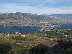
The town is situated on Osoyoos Lake, which has a perimeter of 47.9 km (29.8 mi), an elevation of 276 m (906 ft), a maximum depth of 63 m (207 ft), and a mean depth of 14 m (46 ft). The lake’s elevation marks the lowest point in Canada of the Okanagan Valley.
The far southern reaches of the Okanagan and Similkameen Valleys are part of a threatened ecosystem in Canada known as shrub-steppe. Specifically, the ecosystem of the area is named after the antelope brush plant typical of the local climate. This ecosystem was once more prevalent in the South Okanagan but is now becoming fragmented and degraded due to the spread of agriculture, urban development, and other human activities.
Since 2003, a feasibility study by Parks Canada has been going on to determine the need for protection of a large area of grasslands west of the town known as the South Okanagan-Lower Similkameen National Park Reserve Feasibility Study.[11]
Climate
| Osoyoos | ||||||||||||||||||||||||||||||||||||||||||||||||||||||||||||
|---|---|---|---|---|---|---|---|---|---|---|---|---|---|---|---|---|---|---|---|---|---|---|---|---|---|---|---|---|---|---|---|---|---|---|---|---|---|---|---|---|---|---|---|---|---|---|---|---|---|---|---|---|---|---|---|---|---|---|---|---|
| Climate chart (explanation) | ||||||||||||||||||||||||||||||||||||||||||||||||||||||||||||
| ||||||||||||||||||||||||||||||||||||||||||||||||||||||||||||
| ||||||||||||||||||||||||||||||||||||||||||||||||||||||||||||
The climate, according to the Köppen climate classification, is cold semiarid (BSk)[12] with summers that are generally hot and dry. September and October are usually dry and sunny with cool mornings. Winters are short and mild by Canadian standards, and usually dry, but can be cold for brief periods during Arctic outflow conditions bringing sporadic snowfall. Spring arrives earlier than other parts of the Okanagan. Osoyoos averages 7 months at or above 10 °C (50 °F).
During the summer, the southern Okanagan Valley is on average one of the hottest areas in Canada during the day. Temperatures exceed 35 °C (95 °F) on average 17 days per summer, sometimes topping 38 °C (100 °F).[13] Although days are hot, the humidity is low and nights cool adequately. Daytime temperatures are the hottest in Canada as Osoyoos has the highest average annual daily maximum temperature in Canada 17.0 °C (62.6 °F) as per table below. However, the summer mean is higher in Windsor in Ontario due to warmer nights where July averages 23.0 °C (73.4 °F)[14] The USDA places Osoyoos in Plant Hardiness Zone 7a.[15]
The highest temperature ever recorded in Osoyoos was 42.8 °C (109 °F) on 27 July 1998. The highest daytime low temperature was 25.0 °C (77 °F) on 25 July 2006. [16][17] The coldest temperature ever recorded was −26.1 °C (−15 °F) on 31 December 1968, 23 January 1969, and 29 December 1990.[17]
| Climate data for Osoyoos West, 1981–2010 normals, extremes 1954–present | |||||||||||||
|---|---|---|---|---|---|---|---|---|---|---|---|---|---|
| Month | Jan | Feb | Mar | Apr | May | Jun | Jul | Aug | Sep | Oct | Nov | Dec | Year |
| Record high °C (°F) | 17.5 (63.5) |
17.0 (62.6) |
25.4 (77.7) |
32.8 (91) |
36.1 (97) |
40.9 (105.6) |
42.8 (109) |
41.7 (107.1) |
37.5 (99.5) |
28.9 (84) |
21.1 (70) |
14.9 (58.8) |
42.8 (109) |
| Average high °C (°F) | 2.0 (35.6) |
5.9 (42.6) |
12.5 (54.5) |
17.9 (64.2) |
22.1 (71.8) |
25.7 (78.3) |
29.4 (84.9) |
29.1 (84.4) |
23.8 (74.8) |
15.8 (60.4) |
7.1 (44.8) |
1.6 (34.9) |
16.1 (61) |
| Daily mean °C (°F) | −0.7 (30.7) |
1.6 (34.9) |
6.6 (43.9) |
11.1 (52) |
15.2 (59.4) |
18.7 (65.7) |
21.9 (71.4) |
21.4 (70.5) |
16.5 (61.7) |
10.0 (50) |
3.7 (38.7) |
−0.9 (30.4) |
10.4 (50.7) |
| Average low °C (°F) | −3.4 (25.9) |
−2.7 (27.1) |
0.5 (32.9) |
4.2 (39.6) |
8.2 (46.8) |
11.7 (53.1) |
14.2 (57.6) |
13.6 (56.5) |
9.0 (48.2) |
4.2 (39.6) |
0.3 (32.5) |
−3.4 (25.9) |
4.7 (40.5) |
| Record low °C (°F) | −26.1 (−15) |
−22.0 (−7.6) |
−17.8 (0) |
−6.7 (19.9) |
−3.9 (25) |
0.6 (33.1) |
5.6 (42.1) |
4.0 (39.2) |
−2.2 (28) |
−9.8 (14.4) |
−22.5 (−8.5) |
−26.1 (−15) |
−26.1 (−15) |
| Average precipitation mm (inches) | 28.8 (1.134) |
22.3 (0.878) |
24.0 (0.945) |
24.2 (0.953) |
37.1 (1.461) |
41.7 (1.642) |
24.6 (0.969) |
17.3 (0.681) |
14.9 (0.587) |
18.6 (0.732) |
33.8 (1.331) |
35.8 (1.409) |
323.2 (12.724) |
| Average rainfall mm (inches) | 14.3 (0.563) |
17.7 (0.697) |
22.3 (0.878) |
24.1 (0.949) |
37.1 (1.461) |
41.7 (1.642) |
24.6 (0.969) |
17.3 (0.681) |
14.9 (0.587) |
18.5 (0.728) |
28.2 (1.11) |
18.8 (0.74) |
279.4 (11) |
| Average snowfall cm (inches) | 14.6 (5.75) |
4.6 (1.81) |
1.7 (0.67) |
0.1 (0.04) |
0.0 (0) |
0.0 (0) |
0.0 (0) |
0.0 (0) |
0.0 (0) |
0.1 (0.04) |
5.7 (2.24) |
17.0 (6.69) |
43.8 (17.24) |
| Average precipitation days (≥ 0.2 mm) | 12.0 | 9.2 | 9.9 | 9.7 | 10.4 | 10.2 | 6.7 | 5.5 | 5.2 | 7.8 | 12.2 | 12.3 | 111.1 |
| Average rainy days (≥ 0.2 mm (0.008 in)) | 6.0 | 6.9 | 9.2 | 9.6 | 10.4 | 10.2 | 6.7 | 5.5 | 5.2 | 7.7 | 10.2 | 5.6 | 93.4 |
| Average snowy days (≥ 0.2 cm (0.08 in)) | 6.7 | 2.7 | 1.1 | 0.12 | 0.0 | 0.0 | 0.0 | 0.0 | 0.0 | 0.08 | 2.7 | 7.6 | 20.9 |
| Source: Environment Canada[18][19][20] | |||||||||||||
Average number of days:[18]
- above 20 °C (68 °F): 142.4
- above 30 °C (86 °F): 36.0
- above 35 °C (95 °F): 5.3
Agriculture
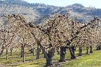
Although the fruit-growing possibilities were noticed by early settlers, the first commercial orchard in the area was not established until 1907, growing cherries, apricots, peaches, plums, and apples.[2] Osoyoos Orchard Limited was formed in 1920 and an irrigation project was planned which finally brought water to the west bench via “The Ditch” in 1927.[2] The former shrub-steppe environment was transformed into a lush agricultural belt and Osoyoos promoted “the earliest fruit in Canada”.
Today, the area continues to produce tree fruits. Aside from tourism, agriculture is a major component of the local economy, as is evident by the abundant produce stands along Highways 3 and 97, and the numerous commercial orchards surrounding the town. With the growing popularity of viticulture, some of these orchards are being converted to vineyards, as the area is a major wine producing region of Canada. After clearing of mainly sagebrush, parcels of bench land have been replanted for viticulture.
The vast majority of the land in the valley bottom surrounding the town is protected by the Agricultural Land Reserve which prevents valuable agricultural lands from being converted into other uses.
Tourism

Tourism in the Osoyoos area has become a large contributor to the local economy. This tourism is brought on by the many amenities in the Osoyoos area.
Osoyoos Lake is "the warmest freshwater lake in Canada" according to the town of Osoyoos[2] and the BC Parks System,[21] with reported average summer water temperatures of 24 °C (75 °F).[22] The lake is surrounded by kilometres of beaches (public and private), parks and picnic grounds, such as Gyro Beach, Lions Centennial Park, Kinsmen Park, Legion Beach and Sẁiẁs Provincial Park. There are also major plans to revitalize the waterfront along the town core,[23] spurred on by recent major developments such as the Watermark Beach Resort which include increased public space and an expanded marina.
Spotted Lake is a saline endorheic alkali lake located northwest of Osoyoos.
There are two centres dedicated to preserving the ecosystem of the Okanagan Desert. The Osoyoos Desert Centre is located 3 km (2 mi) north of Osoyoos off Highway 97,[24] while the Nk'Mip Desert Cultural Centre is located adjacent to the Nk'mip Winery on the Osoyoos Indian Reserve.[25]
The area is served by three 18-hole golf courses - Osoyoos Golf Club, Fairview Mountain Golf Club (Oliver) and the Nk’Mip Canyon Desert Golf Course (Oliver) - and one nine-hole course, Sonora Dunes (Osoyoos).
Demographics
| Historical population | ||
|---|---|---|
| Year | Pop. | ±% |
| 1951 | 899 | — |
| 1956 | 860 | −4.3% |
| 1961 | 1,022 | +18.8% |
| 1966 | 1,166 | +14.1% |
| 1971 | 1,285 | +10.2% |
| 1976 | 2,100 | +63.4% |
| 1981 | 2,738 | +30.4% |
| 1986 | 2,956 | +8.0% |
| 1991 | 3,403 | +15.1% |
| 1996 | 4,127 | +21.3% |
| 2001 | 4,295 | +4.1% |
| 2006 | 4,752 | +10.6% |
| 2011 | 4,845 | +2.0% |
| 2016 | 5,085 | +5.0% |
| Sources: Statistics Canada[26][27] | ||
The town's popularity among retirees is reflected in the age of the average resident at 55.4 years (2016) compared to 40.8 years for the rest of the population of British Columbia.[28] The average age of the Osoyoos senior population is second in Canada only to Qualicum Beach, BC (60.1 years).[28] In 2006, median household income was $43,764, compared to the $52,709 earned per household on average, province-wide.[29]
The town is served by a high school, Osoyoos Secondary School.
Sports
| Club | League | Sport | Venue | Established | Championships |
|---|---|---|---|---|---|
| Osoyoos Coyotes | Ice hockey | Osoyoos Sunbowl Arena |
Notable people
- Chuck Kobasew - retired professional hockey player
- Jack B. Newton - amateur astronomer
- Alison Smith - television journalist and anchor
References
- ↑ "British Columbia Regional Districts, Municipalities, Corporate Name, Date of Incorporation and Postal Address" (XLS). British Columbia Ministry of Communities, Sport and Cultural Development. Retrieved November 2, 2014.
- 1 2 3 4 5 "Osoyoos Town Website". Town of Osoyoos. Retrieved 19 December 2009.
- 1 2 "Osoyoos". BC Geographical Names.
- ↑ "Statistics Canada". statcan.gc.ca. Retrieved 2017-05-12.
- 1 2 "Census profile 2011, Okanagan-Similkameen A Region". Statistics Canada, Government of Canada. 2014. Retrieved 7 April 2014.
- ↑ McGowan's War, Chapter: The Okanagan Trail, Donald J. Hauka, New Star Books, Vancouver (2000) ISBN 1-55420-001-6
- ↑ British Columbia Chronicle, 1847–1871: Gold & Colonists, Helen and G.P.V. Akrigg, Discovery Press, Vancouver (1977) ISBN 0-919624-03-0
- ↑ Claiming the Land, Dan Marshall, UBC Ph.D Thesis, 2002 (unpubl.)
- ↑ "Detailed history on "Crowsnest Highway" website history page". Crowsnest-highway.ca. Retrieved 2011-07-28.
- ↑ Wilma, David (2006-01-30). "''Indians ambush gold prospectors in McLoughlin Canyon (Okanogan Valley) on July 29, 1858'', HistoryLink.org Essay 7614". Historylink.org. Retrieved 2011-07-28.
- ↑ "South Okanagan–Lower Similkameen National Park Reserve Feasibility Study". Pc.gc.ca. Government of Canada, Parks Canada Agency. 2006-11-17. Retrieved 2011-07-28.
- ↑ "World Map of the Köppen-Geiger climate classification updated" (PDF). Meteorologische Zeitschrift, Vol. 15, No. 3, 259-263 (June 2006). Archived from the original (PDF) on 2009-03-27. Retrieved 27 July 2011.
- ↑ "Daily Data | Canada's National Climate Archive". Climate.weatheroffice.gc.ca. 2011-05-18. Retrieved 2011-07-28.
- ↑ "Osoyoos Climate Normals". Environment Canada. Retrieved 22 October 2015.
- ↑ "Interactive Map | USDA Plant Hardiness Zone Map". Planthardiness.ars.usda.gov. Retrieved 2012-10-31.
- ↑ http://climate.weather.gc.ca/climate_data/daily_data_e.html?StationID=1041&timeframe=2&StartYear=1840&EndYear=2018&Day=1&Year=2006&Month=7
- 1 2 "Osoyoos CS". Canadian Climate Normals 1981–2010. Environment Canada. Retrieved 27 June 2016.
- 1 2 "Osoyoos West". Canadian Climate Normals 1981–2010. Environment Canada. Retrieved 5 March 2018.
- ↑ "Daily Data Report for October 1975". Canadian Climate Data. Environment Canada. Retrieved 27 June 2016.
- ↑ "Daily Data Report for June 2015". Canadian Climate Data. Environment Canada. Retrieved 27 June 2016.
- ↑ "Sẁiẁs Provincial Park". BC Parks. Retrieved 2015-10-30.
- ↑ French, Paul (June 24, 2009). "Osoyoos, Canada's lone desert". thestar.com. The Toronto Star. Archived from the original on 2012-10-31. Retrieved 2012-10-31.
- ↑ "CivicWeb: Waterfront Master Plan". Osoyoos.fileprosite.com. Retrieved 2011-07-28.
- ↑ "Osoyoos Desert Society". desert.org. Retrieved 2011-07-28.
- ↑ "Nk'mip Desert Cultural Centre". nkmipdesert.com. Retrieved 2012-10-31.
- ↑ "Osoyoos, Town – British Columbia (Census subdivision)". Statistics Canada. May 10, 2011. Retrieved May 9, 2013.
- ↑ "British Columbia – Municipal Census Populations (1921–2011)". BC Stats. Retrieved 18 June 2017.
- 1 2 "Osoyoos has one of Canada's oldest populations, says 2016 census". Osoyoos Times. 8 May 2017. Retrieved 19 June 2017.
- ↑ "Community Profiles from the 2006 Census, Statistics Canada - Census Subdivision". 2.statcan.gc.ca. 2010-12-06. Retrieved 2011-07-28.
External links
| Wikimedia Commons has media related to Osoyoos. |
| Wikivoyage has a travel guide for Osoyoos. |
| Subdivisions |  | |
|---|---|---|
| Communities | ||
| Metro areas and agglomerations | ||
| Towns | ||
| ||
Coordinates: 49°1′57″N 119°27′58″W / 49.03250°N 119.46611°W
Municipalities and communities of Okanagan, British Columbia, Canada | ||
|---|---|---|
| Cities |  | |
| Towns | ||
| Districts | ||
| Villages | ||
| Designated places |
| |
| Unincorporated communities | ||
| Indian reservations | ||
| Ghost towns | ||
| Footnotes | ‡This populated place also has portions in an adjacent region | |