Waynesville, Missouri
| Waynesville, Missouri | |
|---|---|
| City | |
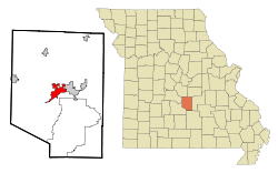 Location of Waynesville, Missouri | |
| Coordinates: 37°49′13″N 92°12′49″W / 37.82028°N 92.21361°WCoordinates: 37°49′13″N 92°12′49″W / 37.82028°N 92.21361°W | |
| Country | United States |
| State | Missouri |
| County | Pulaski |
| Area[1] | |
| • Total | 6.45 sq mi (16.71 km2) |
| • Land | 6.42 sq mi (16.63 km2) |
| • Water | 0.03 sq mi (0.08 km2) |
| Elevation | 807 ft (246 m) |
| Population (2010)[2] | |
| • Total | 4,830 |
| • Estimate (2016)[3] | 5,314 |
| • Density | 750/sq mi (290/km2) |
| Time zone | UTC-6 (Central (CST)) |
| • Summer (DST) | UTC-5 (CDT) |
| ZIP code | 65583 |
| Area code(s) | 573 |
| FIPS code | 29-77992[4] |
| GNIS feature ID | 0752786[5] |
| Website | waynesvillemo.org |
Waynesville is a city in Pulaski County, Missouri, United States. The population was 4,830 at the 2010 census. It is the county seat of Pulaski County[6] and is located in the heart of the Missouri Ozarks. It was one of the communities served by historic Route 66.
History
Waynesville was platted in 1839.[7] The city was named for Anthony Wayne.[8] The post office in Waynesville has been in operation since 1834.[9]
During the American Civil War, Waynesville was sometimes manned by units of the 5th Missouri State Militia.[10]
Geography
Waynesville is located at 37°49′13″N 92°12′49″W / 37.82028°N 92.21361°W (37.820218, -92.213661).[11]
According to the United States Census Bureau, the city has a total area of 6.45 square miles (16.71 km2), of which, 6.42 square miles (16.63 km2) is land and 0.03 square miles (0.08 km2) is water.[1]
Demographics
| Historical population | |||
|---|---|---|---|
| Census | Pop. | %± | |
| 1910 | 257 | — | |
| 1920 | 293 | 14.0% | |
| 1930 | 392 | 33.8% | |
| 1940 | 468 | 19.4% | |
| 1950 | 1,010 | 115.8% | |
| 1960 | 2,377 | 135.3% | |
| 1970 | 3,375 | 42.0% | |
| 1980 | 2,879 | −14.7% | |
| 1990 | 3,207 | 11.4% | |
| 2000 | 3,507 | 9.4% | |
| 2010 | 4,830 | 37.7% | |
| Est. 2017 | 5,230 | [3] | 8.3% |
| U.S. Decennial Census | |||
2010 census
As of the census[2] of 2010, there were 4,830 people, 1,894 households, and 1,252 families residing in the city. The population density was 752.3 inhabitants per square mile (290.5/km2). There were 2,088 housing units at an average density of 325.2 per square mile (125.6/km2). The racial makeup of the city was 73.6% White, 12.4% African American, 1.1% Native American, 3.4% Asian, 0.5% Pacific Islander, 2.5% from other races, and 6.5% from two or more races. Hispanic or Latino of any race were 8.1% of the population.
There were 1,894 households of which 37.8% had children under the age of 18 living with them, 49.3% were married couples living together, 13.3% had a female householder with no husband present, 3.5% had a male householder with no wife present, and 33.9% were non-families. 28.9% of all households were made up of individuals and 8.2% had someone living alone who was 65 years of age or older. The average household size was 2.48 and the average family size was 3.04.
The median age in the city was 32.6 years. 28% of residents were under the age of 18; 8.8% were between the ages of 18 and 24; 30.6% were from 25 to 44; 21.2% were from 45 to 64; and 11.2% were 65 years of age or older. The gender makeup of the city was 47.1% male and 52.9% female.
2000 census
At the 2000 census,[4] there were 3,507 people, 1,428 households and 922 families residing in the city. The population density was 563.3 per square mile (217.3/km²). There were 1,591 housing units at an average density of 255.6 per square mile (98.6/km²). The racial makeup of the city was 79.70% White, 10.98% African American, 0.94% Native American, 2.88% Asian, 0.11% Pacific Islander, 1.43% from other races, and 3.96% from two or more races. Hispanic or Latino of any race were 3.11% of the population.
There were 1,428 households of which 32.5% had children under the age of 18 living with them, 49.6% were married couples living together, 11.6% had a female householder with no husband present, and 35.4% were non-families. 31.3% of all households were made up of individuals and 10.5% had someone living alone who was 65 years of age or older. The average household size was 2.34 and the average family size was 2.93.
27.3% of the population were under the age of 18, 6.4% from 18 to 24, 29.3% from 25 to 44, 23.4% from 45 to 64, and 13.6% who were 65 years of age or older. The median age was 38 years. For every 100 females, there were 89.4 males. For every 100 females age 18 and over, there were 86.0 males.
The median household income was $41,250 and the median family income was $46,205. Males had a median income of $31,435 versus $23,640 for females. The per capita income for the city was $19,117. About 9.5% of families and 11.3% of the population were below the poverty line, including 16.9% of those under age 18 and 17.5% of those age 65 or over.
Climate
Waynesville experiences a humid subtropical climate (Köppen climate classification Cfa) like much of southern Missouri.
| Climate data for Waynesville, Missouri | |||||||||||||
|---|---|---|---|---|---|---|---|---|---|---|---|---|---|
| Month | Jan | Feb | Mar | Apr | May | Jun | Jul | Aug | Sep | Oct | Nov | Dec | Year |
| Record high °F (°C) | 79 (26) |
85 (29) |
87 (31) |
99 (37) |
94 (34) |
104 (40) |
115 (46) |
107 (42) |
104 (40) |
97 (36) |
86 (30) |
79 (26) |
115 (46) |
| Average high °F (°C) | 42 (6) |
48 (9) |
59 (15) |
68 (20) |
75 (24) |
83 (28) |
88 (31) |
87 (31) |
79 (26) |
71 (22) |
57 (14) |
46 (8) |
67 (20) |
| Average low °F (°C) | 20 (−7) |
25 (−4) |
34 (1) |
43 (6) |
53 (12) |
62 (17) |
67 (19) |
65 (18) |
57 (14) |
45 (7) |
34 (1) |
25 (−4) |
44 (7) |
| Record low °F (°C) | −23 (−31) |
−23 (−31) |
−14 (−26) |
13 (−11) |
24 (−4) |
35 (2) |
42 (6) |
36 (2) |
24 (−4) |
11 (−12) |
−3 (−19) |
−25 (−32) |
−25 (−32) |
| Average precipitation inches (mm) | 2.26 (57.4) |
2.40 (61) |
3.98 (101.1) |
4.09 (103.9) |
4.71 (119.6) |
4.19 (106.4) |
3.74 (95) |
3.54 (89.9) |
4.06 (103.1) |
3.88 (98.6) |
4.36 (110.7) |
3.33 (84.6) |
44.54 (1,131.3) |
| Source: [12] | |||||||||||||
Government
Waynesville is classified a 3rd Class City with an elected mayor and city council.
As of the April 2014 election, the mayor is Luge Hardman. Current City Council members are Jerry Brown & Sheryl Folkert (Ward 1), Cecil V. Davis & Clarence Liberty (Ward 2), Ed Conley & Alan Clark (Ward 3), and Michael France & Michael Curtis (Ward 4). Bruce Harrill is City Administrator, and Michele Brown is City Clerk. [13]
Education
Fort Leonard Wood is in Pulaski County and a high percentage of military personnel live off-post in surrounding communities, especially St. Robert and Waynesville, but also the farther-out cities of Richland, Crocker, Dixon, and the unincorporated communities of Laquey, Swedeborg, Doolittle, and Devil's Elbow, all of which have a lower housing cost than both St. Robert and Waynesville. Military personnel assigned to training areas on the south end of the post sometimes choose to live in the unincorporated area of Big Piney in Pulaski County, or the northern Texas County communities of Plato and Roby.
Seven main school districts are fully or partly within the borders of Pulaski County, not counting two small districts which are mostly within other counties and only have only a few dozen residents within Pulaski County. All seven school districts have a high percentage of Fort Leonard Wood military dependents, and over two-thirds of Waynesville students fall into that category.
The cities of Waynesville and St. Robert and the Fort Leonard Wood army installation, along with their surrounding rural areas running east to Devil's Elbow, are served by the Waynesville R-VI School District which is by far the largest in the county.
Other districts serving Pulaski County include the Laquey R-V School District, Richland R-IV School District, Swedeborg R-III School District, Crocker R-II School District, and Dixon R-I School District. The Plato R-V School District is in Texas County but serves the southern portion of Pulaski County.
Waynesville Schools include Williams Early Childhood Development Center (Pre-K - Kindergarten), Wood Elementary (K-5), Pick Elementary (K-5), East Elementary (K-5), Freedom Elementary (K-5), Waynesville Sixth Grade Center (6th), Waynesville Middle School (7 & 8), and Waynesville High School (9-12).
Waynesville has a public library, a branch of the Pulaski County Library District.[14]
Registered historic places
- Old Stagecoach Stop (also known as "Black Hotel" or "Pulaski House")
- Pulaski County Courthouse
Transportation
Waynesville Regional Airport at Forney Field serves the community with air service. Even though it is on Fort Leonard Wood, it is jointly run by the cities of Waynesville and St. Robert and is available for civilian use by private pilots and scheduled commercial passenger service.
The major east-west route is ![]()
![]()
The major north-south routes near Waynesville are:


Major attractions along U.S. Route 66 include the Old Stagecoach Stop in downtown Waynesville, which is now a museum but began as a tavern and boarding house and is the oldest standing structure in the county. It was used as a Civil War hospital for Union troops who were garrisoned above the city in Fort Wayne, which was demolished after the war. The Old Courthouse Museum in downtown Waynesville is near the Old Stagecoach Stop.
The City Of Waynesville does not provide any public transportation (such as buses or shuttles).
Media
Pulaski County has one daily and three weekly print newspapers, as well as an online Internet daily newspaper. The county also has two Internet discussion sites, the Pulaski County Web and Pulaski County Insider.
KFBD-FM and its AM sister station, KJPW, are the dominant news radio providers in the Pulaski County area, which includes Fort Leonard Wood, Waynesville and St. Robert. These stations compete with the only other station broadcasting from Pulaski County, KFLW Radio, owned by the Lebanon Daily Record[15] and working locally from the St. Robert offices of the Pulaski County Mirror[16] weekly newspaper.
The Daily Guide,[17] commonly known as the Waynesville Daily Guide (and formerly called the Gateway Daily Guide), is based in St. Robert and serves the entire county. It is owned by GateHouse Media[18] and is the central printing plant for three other GateHouse newspapers in nearby counties, the daily Camden Lake Sun Leader[19] and Rolla Daily News[20] as well as the weekly St. James Leader-Journal.[21]
The content of the weekly Fort Leonard Wood Guidon[22] is produced under the auspices of Army Public Affairs at Fort Leonard Wood but printed under contract by the Springfield News-Leader,[23] a Gannett-owned[24] newspaper which produces and sells advertisements in the Fort Leonard Wood Guidon. The military contract to produce the Guidon was held by the Lebanon Daily Record until the end of 2002, and previously by the Waynesville Daily Guide for many years.
The weekly Pulaski County Mirror[16] is owned by the Lebanon Daily Record,[15] a family-owned newspaper in an adjoining county. The paper is a merger of the Richland Mirror and Pulaski County Democrat in St. Robert, which were separate weekly papers owned by the Lebanon Daily Record until their owner merged them in 2009.
The Pulaski County Daily News[25] online newspaper is privately owned by a Waynesville resident.
The Pulaski County Insider[26] is run and maintained by a businessman from St. Robert and hosted by a Potosi resident.
The county's other weekly paper, the Dixon Pilot, does not routinely cover Waynesville.
Film
Waynesville appeared in Extreme Home Makeover Special Episode.
Waynesville appeared in the 17th season of The Bachelor.
Waynesville appeared in 2 episodes of the Discovery Channel show Darkness.
References
- 1 2 "US Gazetteer files 2010". United States Census Bureau. Archived from the original on 2012-01-24. Retrieved 2012-07-08.
- 1 2 "American FactFinder". United States Census Bureau. Retrieved 2012-07-08.
- 1 2 "Population and Housing Unit Estimates". Retrieved June 9, 2017.
- 1 2 "American FactFinder". United States Census Bureau. Retrieved 2008-01-31.
- ↑ "US Board on Geographic Names". United States Geological Survey. 2007-10-25. Retrieved 2008-01-31.
- ↑ "Find a County". National Association of Counties. Retrieved 2011-06-07.
- ↑ "Pulaski County Place Names, 1928–1945". The State Historical Society of Missouri. Archived from the original on June 24, 2016. Retrieved November 27, 2016.
- ↑ Eaton, David Wolfe (1917). How Missouri Counties, Towns and Streams Were Named. The State Historical Society of Missouri. p. 343.
- ↑ "Post Offices". Jim Forte Postal History. Retrieved 10 December 2016.
- ↑ Hewett, J. (1994). Supplement to the Official records of the Union and Confederate Armies. Wilmington, NC: Broadfoot Pub. Co. , Volume 35, p. 136
- ↑ "US Gazetteer files: 2010, 2000, and 1990". United States Census Bureau. 2011-02-12. Retrieved 2011-04-23.
- ↑ "Average Weather for Waynesville, Missouri (66583) - Temperature and Precipitation". Weather.com. Retrieved December 19, 2008.
- ↑ http://www.waynesvillemo.org/officials.htm
- ↑ "Locations, Hours, and Closings". Pulaski County Library District. Retrieved 25 March 2018.
- 1 2 http://www.lebanondailyrecord.com/
- 1 2 "Archived copy". Archived from the original on 2011-01-03. Retrieved 2010-11-12.
- ↑ http://www.waynesvilledailyguide.com/
- ↑ http://www.gatehousemedia.com/
- ↑ "Archived copy". Archived from the original on 1999-10-12. Retrieved 2008-12-13.
- ↑ http://www.therolladailynews.com/
- ↑ http://www.leaderjournal.com/
- ↑ http://www.myguidon.com
- ↑ http://www.news-leader.com
- ↑ http://www.gannett.com/
- ↑ http://www.pulaskicountydaily.com/
- ↑ http://www.pulaskicountyinsider.com/
External links
Municipalities and communities of Pulaski County, Missouri, United States | ||
|---|---|---|
| Cities | 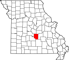 | |
| Townships | ||
| CDP | ||
| Unincorporated communities | ||
| Ghost towns | ||
| Footnotes | ‡This populated place also has portions in an adjacent county or counties | |