Stockton, Missouri
| Stockton, Missouri | |
|---|---|
| City | |
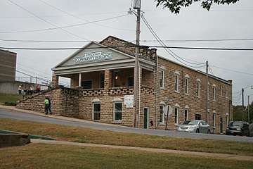 Stockton Community Building | |
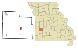 Location of Stockton, Missouri | |
| Coordinates: 37°41′56″N 93°47′46″W / 37.69889°N 93.79611°WCoordinates: 37°41′56″N 93°47′46″W / 37.69889°N 93.79611°W[1] | |
| Country | United States |
| State | Missouri |
| County | Cedar |
| Area[2] | |
| • Total | 2.14 sq mi (5.54 km2) |
| • Land | 2.10 sq mi (5.44 km2) |
| • Water | 0.04 sq mi (0.10 km2) |
| Elevation[1] | 948 ft (289 m) |
| Population (2010)[3] | |
| • Total | 1,800 |
| • Estimate (2016)[4] | 1,800 |
| • Density | 840/sq mi (320/km2) |
| Time zone | UTC-6 (Central (CST)) |
| • Summer (DST) | UTC-5 (CDT) |
| ZIP code | 65785 |
| Area code(s) | 417 |
| FIPS code | 29-70828[5] |
Stockton is a city in Cedar County, Missouri, United States. The population was 1,819 at the 2010 census. It is the county seat of Cedar County.[6]
History
Stockton was platted in 1846.[7] It was originally named Lancaster, but was renamed Fremont in 1847 in honor of John C. Frémont.[8] In 1857 it was renamed again in honor of Robert F. Stockton.[9]
The Montgomery Archeological Site and Stockton Community Building are listed on the National Register of Historic Places.[10]
Geography
According to the United States Census Bureau, the city has a total area of 2.14 square miles (5.54 km2), of which, 2.10 square miles (5.44 km2) is land and 0.04 square miles (0.10 km2) is water.[2]
The town lies just west of the Stockton Lake dam[11] about 40 miles northwest of Springfield.[12]
On May 4, 2003, a large, destructive tornado severely damaged the city of Stockton.[13] After decimating the historic business district and damaging or destroying over 250 homes the tornado proceeded east through the countryside. The storm also caused the deaths of three Stockton residents and injuries of numerous others. The Stockton tornado began in Barton County, Missouri, near Liberal, Missouri, and moved north/eastward through Cedar and Polk counties before dissipating east of the Dallas County line.
Demographics
| Historical population | |||
|---|---|---|---|
| Census | Pop. | %± | |
| 1880 | 407 | — | |
| 1890 | 508 | 24.8% | |
| 1900 | 555 | 9.3% | |
| 1910 | 590 | 6.3% | |
| 1920 | 696 | 18.0% | |
| 1930 | 647 | −7.0% | |
| 1940 | 801 | 23.8% | |
| 1950 | 811 | 1.2% | |
| 1960 | 838 | 3.3% | |
| 1970 | 1,063 | 26.8% | |
| 1980 | 1,432 | 34.7% | |
| 1990 | 1,579 | 10.3% | |
| 2000 | 1,960 | 24.1% | |
| 2010 | 1,819 | −7.2% | |
| Est. 2016 | 1,879 | [4] | 3.3% |
| U.S. Decennial Census[14] | |||
2010 census
As of the census[3] of 2010, there were 1,819 people, 774 households, and 470 families residing in the city. The population density was 866.2 inhabitants per square mile (334.4/km2). There were 949 housing units at an average density of 451.9 per square mile (174.5/km2). The racial makeup of the city was 97.0% White, 0.1% African American, 0.8% Native American, 0.4% Asian, 0.1% Pacific Islander, 0.1% from other races, and 1.6% from two or more races. Hispanic or Latino of any race were 1.4% of the population.
There were 774 households of which 30.5% had children under the age of 18 living with them, 43.9% were married couples living together, 12.0% had a female householder with no husband present, 4.8% had a male householder with no wife present, and 39.3% were non-families. 35.3% of all households were made up of individuals and 22% had someone living alone who was 65 years of age or older. The average household size was 2.26 and the average family size was 2.92.
The median age in the city was 43.7 years. 24.5% of residents were under the age of 18; 6.9% were between the ages of 18 and 24; 20% were from 25 to 44; 22.9% were from 45 to 64; and 25.9% were 65 years of age or older. The gender makeup of the city was 46.4% male and 53.6% female.
2000 census
As of the census[5] of 2000, there were 1,960 people, 814 households, and 473 families residing in the city. The population density was 921.7 people per square mile (355.3/km²). There were 968 housing units at an average density of 455.2 per square mile (175.5/km²). The racial makeup of the city was 95.66% White, 0.41% African American, 0.51% Native American, 1.12% Asian, 0.51% from other races, and 1.79% from two or more races. Hispanic or Latino of any race were 1.94% of the population.
There were 814 households out of which 25.4% had children under the age of 18 living with them, 46.8% were married couples living together, 8.6% had a female householder with no husband present, and 41.8% were non-families. 38.9% of all households were made up of individuals and 23.7% had someone living alone who was 65 years of age or older. The average household size was 2.14 and the average family size was 2.85.
In the city, the population was spread out with 27.5% under the age of 18, 6.7% from 18 to 24, 20.7% from 25 to 44, 18.7% from 45 to 64, and 26.4% who were 65 years of age or older. The median age was 41 years. For every 100 females, there were 93.1 males. For every 100 females age 18 and over, there were 77.4 males.
The median income for a household in the city was $25,353, and the median income for a family was $34,427. Males had a median income of $22,574 versus $19,688 for females. The per capita income for the city was $14,540. About 7.0% of families and 14.8% of the population were below the poverty line, including 21.0% of those under age 18 and 10.5% of those age 65 or over.
Notable people
- Emil Liston (1890–1949), basketball coach and administrator, member of the Basketball Hall of Fame.
References
- 1 2
- 1 2 "US Gazetteer files 2010". United States Census Bureau. Archived from the original on January 24, 2012. Retrieved 2012-07-08.
- 1 2 "American FactFinder". United States Census Bureau. Retrieved 2012-07-08.
- 1 2 "Population and Housing Unit Estimates". Retrieved June 9, 2017.
- 1 2 "American FactFinder". United States Census Bureau. Archived from the original on September 11, 2013. Retrieved 2008-01-31.
- ↑ "Find a County". National Association of Counties. Archived from the original on May 31, 2011. Retrieved 2011-06-07.
- ↑ Eaton, David Wolfe (1916). How Missouri Counties, Towns and Streams Were Named. The State Historical Society of Missouri. p. 273.
- ↑ "Cedar County Place Names, 1928–1945 (archived)". The State Historical Society of Missouri. Archived from the original on 24 June 2016. Retrieved 17 September 2016.
- ↑ "Disappearing Missouri Names". The Kansas City Star. March 19, 1911. p. 15. Retrieved August 15, 2014 – via Newspapers.com.

- ↑ National Park Service (2010-07-09). "National Register Information System". National Register of Historic Places. National Park Service.
- ↑ Stocton, Missouri, 7.5 Minute Topographic Quadrangle, USGS, 1956 (1982 rev)
- ↑ Missouri Atlas & Gazetteer, DeLorme, 1998, First edition, pp. 51-2 ISBN 0-89933-224-2
- ↑ Suhr, Jim. "Tornado Destroys Downtown of Stockton." AP Online. High Beam Research. May 6, 2003 http://www.highbeam.com/doc/1P1-73721959.html
- ↑ "Census of Population and Housing". Census.gov. Archived from the original on May 12, 2015. Retrieved June 4, 2015.
External links
- Historic maps of Stockton in the Sanborn Maps of Missouri Collection at the University of Missouri
• Cedar County Republican newspaper
Municipalities and communities of Cedar County, Missouri, United States | ||
|---|---|---|
| Cities | 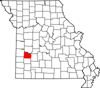 | |
| Villages | ||
| Townships | ||
| Unincorporated communities | ||
| Ghost town | ||
| Footnotes | ‡This populated place also has portions in an adjacent county or counties | |