Maidan Wardak Province
| Wardak وردګ | |
|---|---|
| Province | |
 A gathering of people receiving gifts from the Afghan National Army (ANA) during a patrol in the Sayedabad district of wardak province in November 2011 | |
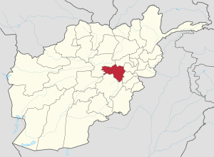 Map of Afghanistan with Wardak highlighted | |
| Coordinates (Capital): 34°24′N 68°24′E / 34.4°N 68.4°ECoordinates: 34°24′N 68°24′E / 34.4°N 68.4°E | |
| Country |
|
| Capital | Maidan Shar |
| Government | |
| • Governor | Muhammad Arif Shah Jahan |
| Area | |
| • Total | 9,934 km2 (3,836 sq mi) |
| Population (2013)[1] | |
| • Total | 567,600 |
| • Density | 57/km2 (150/sq mi) |
| ISO 3166 code | AF-WAR |
| Main languages |
Pashto Persian |
Wardak Province (Pashto: د وردگ ولايت, Persian: ولایت وردک), also called Wardag or simply Wardak Province, is one of the 34 provinces of Afghanistan, located in the central region of Afghanistan. It is divided into eight districts and has a population of approximately 567,600.[1] The capital of the province is Maidan Shar, while the most populous district in the province is Saydabad District. The name of the province is only Wardak according to Afghan constitution and IDLG approved documents
History
During the communist times, the people of Wardak never gave significant support to the communist government.[2] Wardak Province was significant during the Civil War in Afghanistan, due to its proximity with Kabul and its agricultural lands. Hezb-e Wahdat had significant presence in the area. Most of the area was captured by the Taliban around winter 1995.[2]
The security situation rapidly deteriorated in Maidan Wardak in 2008 and 2009. According to a report by Mohammad Osman Tariq Elias, both Logar and Wardak, by the end of 2008, were under de facto Taliban control.[2] As of April 2009, the Ministry of the Interior (Afghanistan) had listed the entire province as "High Risk."[3]
Geography
Wardak province is located in the central and eastern region of Afghanistan; bordering Parwan to the northeast, Kabul and Logar to the east, Ghazni to the south and Bamyan to the west. The capital of Wardak province is Maidan Shar, which is located about 35 km from Kabul. Wardak province covers an area of 9,934 km2. It is mountainous like the rest of the country with plains and many valleys. The majority of its residents live in rural areas. The most heavily populated areas are along the Kabul–Kandahar Highway. The rest of the province is thinly populated, with villages concentrated in areas with available irrigation and water sources (CSO and UNFPA, 2003). Famous passes include the Unai Pass and the Hajigak Pass.
Politics and governance
The current governor of the province is Mohammad Halim Fidai. His predecessor was Abdul Jabbar Naeemi. The town of Maidan Shar serves as the capital of the province. All law enforcement activities throughout the province are conducted by the Afghan National Police (ANP) along with the Afghan Local Police (ALP). The provincial police chief represents the Ministry of the Interior in Kabul. The ANP is backed by other Afghan National Security Forces (ANSF), including the NATO-led forces.
Economics and industry
In terms of industry, one marble factory is working in the province, and there are marble mines in the provincial center and Sayed Abad District although no mining is currently undertaken there due to the government ban. The majority of commercial activity in Maidan Wardak is related to trade in agricultural and livestock products, although stone quarrying is also a growing business in the area. The people from Maidan Wardak are also expert in karez cleaning and repair and go to other parts of the country for this purpose. In Maidan Wardak, there are many natural resources like petroleum, iron, rubies, and many historical artifacts that have been found by the people, but have been kept secret.
Agriculture is a major source of revenue for 43% of households in Maidan Wardak province. Four fifths (79%) of rural households own or manage agricultural land or garden plots in the province. However, nearly a quarter (24%) of households in the province derive income from trade and services, and around half (45%) of households earn some income through non-farm related labor.
Education
The overall literacy rate in Wardak province is 25%. There are around 251 primary and secondary schools in the province catering for 105,358 students. There are 2909 teachers teaching in these schools.[4]
Demographics

As of 2013, the total population of Wardak province is about 567,600,[1] which is multi-ethnic and mostly a tribal society. According to the Institute for the Study of War, "Roughly 70 percent of the population is Pashtuns, Hazara and Tajiks comprise the remainder of the population. The Tajiks live primarily in northern districts of the province, while the Hazaras live in the western part of the province. Maydan Wardak also has a small population of Qizilbashs, who are ethnically Persian and practice Shi’a Islam. The major Pashtun tribes are the Ghilzai (of the Hotak and Kharoti clans) and Wardak."[5][6]
Districts
| District | Capital | Population[7] | Area[8] | Notes |
|---|---|---|---|---|
| Chaki Wardak | Chaki Wardak | 83,376 | 1,273 | |
| Day Mirdad | Miran | 28,865 | ||
| Hisa-I-Awali Bihsud | 25,079 | |||
| Jaghatu | 46,667 | Shifted from Ghazni Province in 2005 | ||
| Jalrez | 44,873 | |||
| Markazi Bihsud | Behsud | 94,328 | ||
| Maidan Shar | Maidan Shar | 35,008 | ||
| Nirkh | 56,354 | |||
| Saydabad | Saydabad | 114,793 | 1,163 |
See also
References
- 1 2 3 "Settled Population of by Civil Division, Urban, Rural and Sex-2012-13" (PDF). Islamic Republic of Afghanistan, Central Statistics Organization. Retrieved 2014-10-24.
- 1 2 3 Elias, Mohammed Osman Tariq (2009). "The Resurgence of the Taliban in Kabul, Logar and Wardak". In Giustozzi, Antonio. Decoding the New Taliban: Insights from the Afghan Field. Hurst & Company. ISBN 978-1-85065-961-7.
- ↑ British Broadcasting Corporation. Afghanistan: Security Map. 19 August 2009. Accessed at: http://news.bbc.co.uk/2/hi/south_asia/8194230.stm Accessed on [28 September 2009]
- ↑ "Ministry of Rural Rehabilitation and Development" (PDF). Mrrd.gov.af. 2012-08-04. Retrieved 2012-08-15.
- ↑ "Maydan Wardak Province". Understanding War. Archived from the original on 2013-09-25. Retrieved 2013-09-25.
- ↑ "Paktia Province" (PDF). Program for Culture & Conflict Studies. Naval Postgraduate School. Retrieved 2014-10-20.
- ↑ http://www.mrrd.gov.af/nabdp/Provincial%20Profiles/Wardak%20PDP%20Provincial%20profile.pdf Wardak Provincial Profile - MRRD
- ↑ Afghanistan Geographic & Thematic Layers
External links
| Wikimedia Commons has media related to Wardak Province. |
- Wardak Province by the Institute for the Study of War
- Wardak Province by the Naval Postgraduate School
Places adjacent to Maidan Wardak Province | ||||||||||
|---|---|---|---|---|---|---|---|---|---|---|
| ||||||||||