Vanua Lava
| Native name: Vōnōlav | |
|---|---|
 Map of Vanua Lava | |
 | |
| Geography | |
| Location | Pacific Ocean |
| Coordinates | 13°48′S 167°28′E / 13.800°S 167.467°ECoordinates: 13°48′S 167°28′E / 13.800°S 167.467°E |
| Archipelago | Vanuatu, Banks Islands |
| Area | 314 km2 (121 sq mi) |
| Highest elevation | 921 m (3,022 ft) |
| Highest point | Mount Suretamate |
| Administration | |
| Province | Torba Province |
| Largest settlement | Sola |
| Demographics | |
| Population | 2,623 (2009) |
| Pop. density | 8.35 /km2 (21.63 /sq mi) |
Vanua Lava is the second largest of the Banks Islands in Torba Province, Vanuatu, after slightly larger Gaua.
It is located about 120 km north-northeast of Espiritu Santo and north of Gaua.
History
Vanua Lava was first sighted by Europeans during the Spanish expedition of Pedro Fernández de Quirós, from 25 to 29 April 1606. The island’s name was then charted as Portal de Belén (“Nativity scene”, in Spanish).[1]
Vanua Lava was first explored by New Zealand Bishop George Augustus Selwyn in 1859. The sulfur deposits of Mt. Suretamate were formerly worked by a French company. Copra is the chief export.
Geography
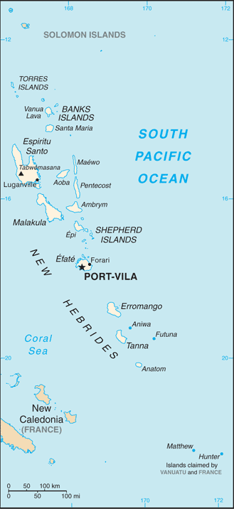
The island measures about 25 km north-to-south and 20 km east-to-west. It has a land area of 314 km².
The highest altitude on the island is 946 metres (3,104 feet). Mount Seretimiat (also spelled Sere’ama, 921 metres (3,022 feet)) is an active volcano, whose last major eruption was in 1965. The island has two natural harbors, Port Patteson in the east and Vureas Bay (Vurës) in the southwest. To the east of the island are the islets of Kwakea and Ravenga. On the west side is Waterfall Bay.
The capital of Torba province, Sola, is located on the east side of the island, on Port Patteson.
Population and languages
The population of Vanua Lava numbered 2,623 in the 2009 census.[2]
Vanua Lava is home to four indigenous languages:[3][4] Vurës with about 2000 speakers, Vera'a with 500; and two dying languages, Mwesen with 10 speakers, and Lemerig with only 2 speakers living. To these four local languages, one may add those of migrant communities: Mwotlap on the north-eastern coast, Mota by some families in the east. Bislama is the language most often heard in Sola, the administrative capital where people from different language backgrounds meet.
Vanua Lava evidently used to harbour more languages in the past, several of which have disappeared since the mid 19th century.[5]
Transportation
There is an airport there (IATA code SLH), to which Air Vanuatu flies three times a week. There is one road on the island but few vehicles.
References
- François, Alexandre (2012), "The dynamics of linguistic diversity: Egalitarian multilingualism and power imbalance among northern Vanuatu languages", International Journal of the Sociology of Language, 214: 85–110, doi:10.1515/ijsl-2012-0022
References
- ↑ Kelly, Celsus, O.F.M. La Austrialia del Espíritu Santo. The Journal of Fray Martín de Munilla O.F.M. and other documents relating to the Voyage of Pedro Fernández de Quirós to the South Sea (1605-1606) and the Franciscan Missionary Plan (1617-1627) Cambridge, 1966, p.39, 62.
- ↑ 2623 = sum of Vanua Lava + Kwakea figures in 2009 census: "2009 National Census of Population and Housing: Summary Release" (PDF). Vanuatu National Statistics Office. 2009. Retrieved Nov 23, 2010.
- ↑ Cf. François (2012).
- ↑ Detailed list and map of the Banks and Torres languages.
- ↑ François (2012):89-90).
