Toga (island)
 Map of Toga Island | |
 | |
| Geography | |
|---|---|
| Location | Pacific Ocean |
| Coordinates | 13°25′S 166°41′E / 13.417°S 166.683°ECoordinates: 13°25′S 166°41′E / 13.417°S 166.683°E |
| Archipelago | Vanuatu, Torres Islands |
| Area | 18.8[1] km2 (7.3 sq mi) |
| Highest elevation | 104 m (341 ft) |
| Highest point | Mt Lemeura |
| Administration | |
| Province | Torba Province |
| Largest settlement | Sola |
| Demographics | |
| Population | 250 (2012) |
Toga is an island in the Torres Islands archipelago in Torba Province of Vanuatu in the southwestern Pacific Ocean.[2][3][4]
Geography
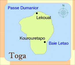
Toga Island is the most southern of the Torres Islands. The island's size is 6 km by 4.5 km. The estimated terrain elevation above sea level is 104 meter.[5] Toga is surrounded by a narrow fringing reef quickly dropping off into deep water. The summit of the island is Mt Lemeura located on the western side of the island.[6]
Population
The local population speaks Lo-Toga language and is some 250 people strong, living in two villages. Toga is, nevertheless, the most populated place in the Torres Islands.
References
- ↑ "Vanuatu". Haos Blong Volkeno. Retrieved 8 August 2018.
- ↑ "Welcome to Torres Islands". Lonely Planet. Retrieved 5 August 2018.
- ↑ "Torres". Vanuatu Travel. Retrieved 5 August 2018.
- ↑ "Torres Islands". Encyclopædia Britannica. Retrieved 5 August 2018.
- ↑ "Toga Island". Geoview. Retrieved 5 August 2018.
- ↑ Seech, John. "Toga Island, Vanuatu - John Seach". Vanuatu Travel. Retrieved 5 August 2018.

This article is issued from
Wikipedia.
The text is licensed under Creative Commons - Attribution - Sharealike.
Additional terms may apply for the media files.