Torba Province
Coordinates: 13°45′S 167°30′E / 13.750°S 167.500°E
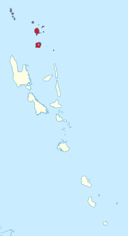
Torba in Vanuatu
Torba (or TorBa) is the northernmost province of Vanuatu, consisting of the Banks Islands and the Torres Islands.
The province's name is derived from the initial letters of TORres and BAnks.
Population
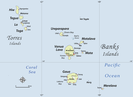
Detailed map of Torba province (Torres-Banks)
The province has a population of 9,359 people[1] and an area of 882 square kilometres (341 square miles). Its capital is Sola on Vanua Lava.
Islands
These are the main islands of Torba Province, excluding smaller and uninhabited islets.
- Banks Islands
| Name | Population | Area in km2 |
|---|---|---|
| Gaua | 2,491 | 342 |
| Kwakéa | 26 | |
| Merelava | 647 | |
| Merig | 12 | |
| Mota | 683 | 9,5 |
| Motalava | 1,451 | 24 |
| Ra | 189 | 0,5 |
| Ureparapara | 437 | 39 |
| Vanua Lava | 2,597 | 314 |
- Torres Islands
| Name | Population | Area in km2 |
|---|---|---|
| Hiw | 269 | 51 |
| Linua | 0 | |
| Lo | 210 | |
| Metoma | 13 | |
| Tegua | 58 | |
| Toga | 276 |
Culture and languages
Seventeen languages, all Oceanic, are spoken in the Torba province.[2]
References
- ↑ "2009 National Census of Population and Housing: Summary Release" (PDF). Vanuatu National Statistics Office. 2009. Retrieved October 11, 2010.
- ↑ François (2012). A list and map of these 17 languages of Torba province can be found on this page.
Bibliography
- François, Alexandre (2012), "The dynamics of linguistic diversity: Egalitarian multilingualism and power imbalance among northern Vanuatu languages", International Journal of the Sociology of Language, 214: 85–110, doi:10.1515/ijsl-2012-0022

This article is issued from
Wikipedia.
The text is licensed under Creative Commons - Attribution - Sharealike.
Additional terms may apply for the media files.