Maewo
| Maewo | |
|---|---|
| Island | |
 Maewo | |
 Location within Vanuatu | |
| Coordinates: 15°10′S 168°10′E / 15.167°S 168.167°ECoordinates: 15°10′S 168°10′E / 15.167°S 168.167°E | |
| Country |
|
| Province | Penama Province |
| Area | |
| • Total | 269 km2 (104 sq mi) |
| Elevation | 795 m (2,608 ft) |
| Population (2009) | |
| • Total | 3,569 |
| • Density | 13/km2 (34/sq mi) |
| Time zone | UTC+11 (VUT) |
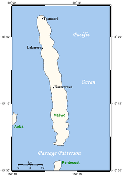
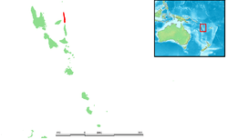
Maewo (local pronunciation: [ŋʷaewo]; formerly Aurora Island) is an island in Vanuatu in Penama province, 105 km to the east of Espiritu Santo.
It is 47 km long, and 6 km wide, with an area of 269 km². Its highest point is 795 m above sea level. In 2009 the island had a population of almost 3,600.[1]
History
First recorded sighting of Maewo Island by Europeans was by the Spanish expedition of Pedro Fernández de Quirós at the end of April 1606.[2] They charted it as Aurora (The light of dawn in Spanish).
Geography
Maewo is the island with the highest rainfall in Vanuatu, greater than 2500 mm per year. The island is covered in green, lush vegetation. The heavy rainfall provides abundant fresh water and waterfalls. There are also hot springs in the centre of Maewo. The largest of these waterfalls is a series of cascades located near Maewo-Naone Airport on the north end of the island near the village of Naone. This series of cascades is commonly referred to as Big Wota.
References
- ↑ 2009 Census Summary release final Archived 2013-12-21 at the Wayback Machine. - Government of Vanuatu
- ↑ Brand, Donald D. The Pacific Basin: A History of its Geographical Explorations The American Geographical Society, New York, 1967, p.133.
