Ulvik
| Ulvik herad | |||
|---|---|---|---|
| Municipality | |||
 View of the Ulvik area | |||
| |||
 Ulvik within Hordaland | |||
| Coordinates: 60°37′16″N 07°04′49″E / 60.62111°N 7.08028°ECoordinates: 60°37′16″N 07°04′49″E / 60.62111°N 7.08028°E | |||
| Country | Norway | ||
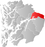
| County | Hordaland | ||
| District | Hardanger | ||
| Administrative centre | Ulvik | ||
| Government | |||
| • Mayor (2011) | Hans Petter Thorbjørnsen (Ap) | ||
| Area | |||
| • Total | 720.00 km2 (277.99 sq mi) | ||
| • Land | 663.39 km2 (256.14 sq mi) | ||
| • Water | 58.61 km2 (22.63 sq mi) | ||
| Area rank | #154 in Norway | ||
| Population (2017) | |||
| • Total | 1,131 | ||
| • Rank | #384 in Norway | ||
| • Density | 1.7/km2 (4/sq mi) | ||
| • Change (10 years) | -0.5% | ||
| Demonym(s) | Ulvikje[1] | ||
| Time zone | UTC+01:00 (CET) | ||
| • Summer (DST) | UTC+02:00 (CEST) | ||
| ISO 3166 code | NO-1233 | ||
| Official language form | Nynorsk | ||
| Website |
www | ||
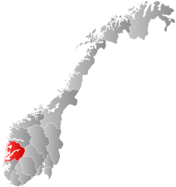
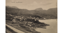
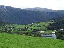
Ulvik is a municipality in Hordaland county, Norway. The municipality stretches from the Hardangerfjord to the mountains that reach 1,800 metres (5,900 ft) above sea level. The administrative centre of the municipality is the village of Ulvik. The villages of Osa and Finse are also located in Ulvik municipality.
The 722-square-kilometre (279 sq mi) municipality is the 154th largest by area out of the 422 municipalities in Norway. Ulvik is the 384th most populous municipality in Norway with a population of 1,131. The municipality's population density is 1.7 inhabitants per square kilometre (4.4/sq mi) and its population has decreased by 0.5% over the last decade.[2] Of the municipality's total population, nearly half live in the village of Ulvik at the end of the Ulvikafjorden. The vast majority of those who do not live in the village of Ulvik live on the farms surrounding the village or at the end of the Osa Fjord in the village of Osa.
In 2016 the chief of police formally suggested that the police station be closed down.[3]
General information

The parish of Graven (later spelled "Granvin") was established as a municipality on 1 January 1838 (see formannskapsdistrikt). This large municipality/parish included two annexes: Ulvik and Eidfjord. On 1 January 1859, Ulvik became the main parish, making Graven and Eidfjord annexes to Ulvik, and the name of the large municipality was changed from Graven to Ulvik.
On 1 May 1891, the western annex of Graven (population: 1,331) and the southeastern annex of Eidfjord (population: 1,018) were separated from Ulvik to become separate municipalities. This left Ulvik with a much smaller size and 1,410 residents. In 1895, a small area of Eidfjord (population: 3) was transferred to Ulvik.[4]
Name
The municipality (originally the parish) is named after the old "Ulvik" farm (Old Norse: Ulfvík), since the first Ulvik Church was built there. The first element is ulfr means "wolf", the last element is vík which means "cove" or "wick".[5][6]
Coat-of-arms
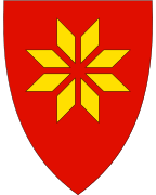
The coat-of-arms is modern, having been granted on 19 December 1986. They are red with a yellow figure shown in the center of the arms. The figure is a traditional design seen in the local folk-art and in local textiles. The pattern can be traced in local arts as far back as the 16th century, and is similar to the selburose. This figure is also used in the bunad of Ulvik.[7]
Churches
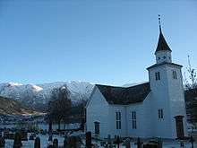
The Church of Norway has one parish (sokn) within the municipality of Ulvik. It is part of the Hardanger og Voss deanery in the Diocese of Bjørgvin.
| Parish (Sokn) | Church Name | Location of the Church | Year Built |
|---|---|---|---|
| Ulvik | Ulvik Church | Ulvik | 1859 |
Geography
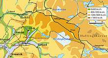
The municipality is situated around the Hardangerfjord's northeastern arms: the Osa Fjord and Ulvikafjorden, extending far into the Hardangervidda plateau. The northernmost part of the Hardangerjøkulen glacier is in Ulvik. The Finse and Hallingskeid areas lie just south of the Hallingskarvet National Park which partially sits inside Ulvik and includes the Hallingskarvet mountains. The municipality of Ulvik borders the municipalities of Granvin, Eidfjord, Ullensvang, Voss, Aurland, and Hol. Lakes in the region include Finsevatnet and Flakavatnet. The headwaters of the Flåmselvi river also lie in Ulvik.
History
| Historical population | ||
|---|---|---|
| Year | Pop. | ±% |
| 1951 | 1,548 | — |
| 1960 | 1,488 | −3.9% |
| 1970 | 1,351 | −9.2% |
| 1980 | 1,362 | +0.8% |
| 1990 | 1,239 | −9.0% |
| 2000 | 1,222 | −1.4% |
| 2010 | 1,129 | −7.6% |
| 2014 | 1,094 | −3.1% |
| Source: Statistics Norway. | ||
After the dissolution of the union between Norway and Sweden 1905, Ulvik was one of the few municipalities that returned a majority in favour of a republic rather than a monarchy in the national referendum on the issue.
The village of Ulvik was nearly totally destroyed on 25 April 1940, during the German invasion of Norway, when fighting erupted between a German landing party arriving in boats, and a Norwegian force on land. Most of the village was burned down, and three civilians were killed. An unknown number of German soldiers were also killed in the fighting.
Government
All municipalities in Norway, including Ulvik, are responsible for primary education (through 10th grade), outpatient health services, senior citizen services, unemployment and other social services, zoning, economic development, and municipal roads. The municipality is governed by a municipal council of elected representatives, which in turn elect a mayor.
Municipal council
The municipal council (kommunestyre) of Ulvik is made up of 17 representatives that are elected to four year terms. Currently, the party breakdown is as follows:[8]
| Party Name | Name in Norwegian | Number of representatives | |
|---|---|---|---|
| Labour Party | Arbeiderpartiet | 5 | |
| Conservative Party | Høgre | 2 | |
| Centre Party | Senterpartiet | 4 | |
| Socialist Left Party | Sosialistisk Venstreparti | 2 | |
| Liberal Party | Venstre | 4 | |
| Total number of members: | 17 | ||
Transportation
It takes around two hours to drive from the city of Bergen to Ulvik via the European route E16 highway to Vossevangen and then taking Norwegian National Road 13 through the Vallavik Tunnel to Ulvik. The Norwegian National Road 13 continues through Ulvik before crossing the Hardanger Bridge which goes over the Hardangerfjord. The nearest airport is Bergen Flesland Airport in Bergen.
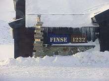
The Bergen Line runs through the northern part of Ulvik. It runs through a region that has no road access, but is a popular with hiking and sports enthusiasts. The railway station at Finse on the Bergen Line at an elevation of 1,222 metres (4,009 ft) is the highest station on the Norwegian railway system. The Finse Tunnel just outside Finse is one of the longest railway tunnels in Norway. The Rallarvegen "road" is an historic road that follows the Bergen Line through Ulvik. It is a popular biking and hiking route. Ulvik is also visited in the summer by numerous foreign cruise ships who travel along the fjord.
Famous residents
- Terje Breivik (born 1965), a politician
- Olav H. Hauge (1908–1994), a poet
- Lars Osa (1860–1958), an artist and musician
- Lars Sponheim (born 1957), a politician
References
- ↑ "Navn på steder og personer: Innbyggjarnamn" (in Norwegian). Språkrådet. Retrieved 2015-12-01.
- ↑ Statistisk sentralbyrå (2017). "Table: 06913: Population 1 January and population changes during the calendar year (M)" (in Norwegian). Retrieved 2017-10-29.
- ↑ https://www.nrk.no/hordaland/slik-vil-songstad-ha-vest-politidistrikt-1.13284803
- ↑ Jukvam, Dag (1999). "Historisk oversikt over endringer i kommune- og fylkesinndelingen" (PDF) (in Norwegian). Statistisk sentralbyrå.
- ↑ Brekke, Nils Georg; Skaar, Ronny B.; Nord, Svein (1993). Kulturhistorisk Vegbok Hordaland (in Norwegian). Nord4.
- ↑ Rygh, Oluf (1910). Norske gaardnavne: Søndre Bergenhus amt (in Norwegian) (11 ed.). Kristiania, Norge: W. C. Fabritius & sønners bogtrikkeri. p. 475.
- ↑ "Civic heraldry of Norway - Norske Kommunevåpen". Heraldry of the World. Retrieved 2014-05-29.
- ↑ "Table: 04813: Members of the local councils, by party/electoral list at the Municipal Council election (M)" (in Norwegian). Statistics Norway. 2015.
External links
| Wikimedia Commons has media related to Ulvik. |
| Look up Ulvik in Wiktionary, the free dictionary. |

- Municipal fact sheet from Statistics Norway (in Norwegian)
- Municipality website (in Norwegian)
- Ulvik Tourist Office (available in English/German/Norwegian)