Uherský Ostroh
| Uherský Ostroh | |||
| Town | |||
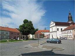 Town square | |||
|
|||
| Name origin: Hungarian promontory | |||
| Country | Czech Republic | ||
|---|---|---|---|
| Region | Zlín | ||
| District | Uherské Hradiště | ||
| Commune | Uherské Hradiště | ||
| Municipality | Uherský Ostroh | ||
| River | Morava | ||
| Elevation | 178 m (584 ft) | ||
| Coordinates | 48°59′15″N 17°22′54″E / 48.98750°N 17.38167°ECoordinates: 48°59′15″N 17°22′54″E / 48.98750°N 17.38167°E | ||
| Area | 26.52 km2 (10.24 sq mi) | ||
| Population | 4,483 (2006-08-28) | ||
| Density | 169/km2 (438/sq mi) | ||
| First mentioned | 1286 | ||
| Mayor | Vlastimil Vaněk | ||
| Timezone | CET (UTC+1) | ||
| - summer (DST) | CEST (UTC+2) | ||
| Postal code | 687 24 | ||
  Location in the Czech Republic | |||
| Wikimedia Commons: Uherský Ostroh | |||
| Statistics: statnisprava.cz | |||
| Website: uhostroh.cz | |||
Uherský Ostroh (Czech pronunciation: [ˈuɦɛrskiː ˈostrox]) is a town in the Uherské Hradiště District, Zlín Region, Czech Republic, located about 11 km southwest of Uherské Hradiště. It lies in the ethnographic Slovácko region.
| Wikimedia Commons has media related to Uherský Ostroh. |
| Authority control |
|---|
This article is issued from
Wikipedia.
The text is licensed under Creative Commons - Attribution - Sharealike.
Additional terms may apply for the media files.