Bánov (Uherské Hradiště District)
| Bánov | |||
|---|---|---|---|
| Municipality | |||
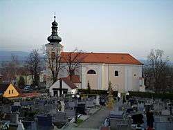 Saint Martin Church | |||
| |||
 Bánov | |||
| Coordinates: 48°59′16″N 17°43′3″E / 48.98778°N 17.71750°ECoordinates: 48°59′16″N 17°43′3″E / 48.98778°N 17.71750°E | |||
| Country |
| ||
| Region | Zlín | ||
| District | Uherské Hradiště | ||
| Government | |||
| Area | |||
| • Total | 16.24 km2 (6.27 sq mi) | ||
| Elevation | 287 m (942 ft) | ||
| Population (2006) | |||
| • Total | 2,098 | ||
| • Density | 130/km2 (330/sq mi) | ||
| Postal code | 687 54 | ||
| Website | http://www.banov.cz/ | ||


Bánov is a village and municipality (obec) in Uherské Hradiště District in the Zlín Region of the Czech Republic.
The municipality covers an area of 16.24 square kilometres (6.27 sq mi), and has a population of 2,098 (as at 1 January 2017).
Bánov lies approximately 21 kilometres (13 mi) south-east of Uherské Hradiště, 28 km (17 mi) south of Zlín, and 268 km (167 mi) south-east of Prague.
References
This article is issued from
Wikipedia.
The text is licensed under Creative Commons - Attribution - Sharealike.
Additional terms may apply for the media files.