Bystřice pod Lopeníkem
| Bystřice pod Lopeníkem | |||
|---|---|---|---|
| Municipality | |||
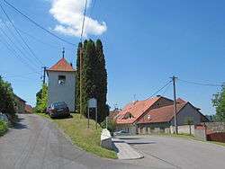 Belfry | |||
| |||
 Bystřice pod Lopeníkem | |||
| Coordinates: 48°58′9″N 17°46′16″E / 48.96917°N 17.77111°ECoordinates: 48°58′9″N 17°46′16″E / 48.96917°N 17.77111°E | |||
| Country |
| ||
| Region | Zlín | ||
| District | Uherské Hradiště | ||
| Area | |||
| • Total | 13.42 km2 (5.18 sq mi) | ||
| Elevation | 365 m (1,198 ft) | ||
| Population (2006) | |||
| • Total | 814 | ||
| • Density | 61/km2 (160/sq mi) | ||
| Postal code | 687 55 | ||


Bystřice pod Lopeníkem is a village and municipality (obec) in Uherské Hradiště District in the Zlín Region of the Czech Republic.
The municipality covers an area of 13.42 square kilometres (5.18 sq mi), and has a population of 814 (as at 3 July 2006).
Bystřice pod Lopeníkem lies approximately 26 kilometres (16 mi) south-east of Uherské Hradiště, 31 km (19 mi) south of Zlín, and 272 km (169 mi) south-east of Prague.
References
| Wikimedia Commons has media related to Bystřice pod Lopeníkem. |
This article is issued from
Wikipedia.
The text is licensed under Creative Commons - Attribution - Sharealike.
Additional terms may apply for the media files.