Huštěnovice
| Huštěnovice | |||
|---|---|---|---|
| Municipality | |||
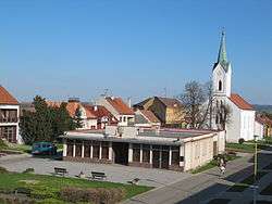 Saint Anne Church | |||
| |||
 Huštěnovice | |||
| Coordinates: 49°6′21″N 17°28′19″E / 49.10583°N 17.47194°ECoordinates: 49°6′21″N 17°28′19″E / 49.10583°N 17.47194°E | |||
| Country |
| ||
| Region | Zlín | ||
| District | Uherské Hradiště | ||
| Area | |||
| • Total | 6.59 km2 (2.54 sq mi) | ||
| Elevation | 186 m (610 ft) | ||
| Population (2006) | |||
| • Total | 1,004 | ||
| • Density | 150/km2 (390/sq mi) | ||
| Postal code | 687 03 | ||
| Website | http://www.hustenovice.cz | ||

Huštěnovice is a village and municipality (obec) in Uherské Hradiště District in the Zlín Region of the Czech Republic.
The municipality covers an area of 6.59 square kilometres (2.54 sq mi), and has a population of 1,004 (as at 28 August 2006).
Huštěnovice lies approximately 5 kilometres (3 mi) north of Uherské Hradiště, 21 km (13 mi) south-west of Zlín, and 246 km (153 mi) south-east of Prague.
References
| Wikimedia Commons has media related to Huštěnovice. |
This article is issued from
Wikipedia.
The text is licensed under Creative Commons - Attribution - Sharealike.
Additional terms may apply for the media files.