Katapady
| Katapady ಕಟಪಾಡಿ Katpadi | |
|---|---|
| Village | |
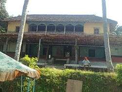 Ruined facade of Katapady Beedu, the manor of the erstwhile Bunt rulers of Katapady | |
| Coordinates: 12°54′52″N 75°11′09″E / 12.91448°N 75.18597°ECoordinates: 12°54′52″N 75°11′09″E / 12.91448°N 75.18597°E | |
| Country |
|
| State |
|
| District | Udupi |
| Government | |
| • Body | Grama Panchayat |
| Languages | |
| Time zone | UTC+5:30 (IST) |
| PIN | 574105 |
| Telephone code | 0820-557 |
| Vehicle registration | KA-20 |
| Nearest city | Udupi |
| Literacy | Approx 99% |
| Lok Sabha constituency | Udupi |
| Vidhan Sabha constituency | Kaup |
| Civic agency | Grama Panchayat |
| Climate | Humid (Köppen) |
Katapady is a village near Udupi in Karnataka, India. It is situated at the junction of National Highway 17 and the roads leading to Mattu and Shankarapura. Katapadi is surrounded by lush green fields, rivers and a beautiful beach. Katapadi is well known for Mattu Gulla (a type of eggplant), Kambala and jasmine (mallige in Tulu). The name Katapadi is derived from "Kattu paadi" which means "tie it down" in Tulu. Apparently the place is named Katapadi after a lost horse which was found and tied down here.
Transportation
National Highway NH-66 passes through Katapady. Udupi is 7 km from Katapady.
Nearby places
External links
This article is issued from
Wikipedia.
The text is licensed under Creative Commons - Attribution - Sharealike.
Additional terms may apply for the media files.