U.S. Route 33 in Ohio
| ||||
|---|---|---|---|---|
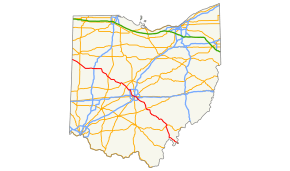 Route of US 33 highlighted in red | ||||
| Route information | ||||
| Maintained by ODOT | ||||
| Length | 236.80 mi[1] (381.09 km) | |||
| Existed | 1926–present | |||
| Major junctions | ||||
| West end |
| |||
| East end |
| |||
| Location | ||||
| Counties | Van Wert, Mercer, Auglaize, Logan, Union, Franklin, Fairfield, Hocking, Athens, Meigs | |||
| Highway system | ||||
| ||||

U.S. Route 33 (US 33) is a United States Numbered Highway running from near Elkhart, Indiana, to Richmond, Virginia. Within the state of Ohio, it is a predominantly southeast–northwest highway running from west of Willshire before crossing over into West Virginia via the Ravenswood Bridge over the Ohio River. The route runs through largely rural territory throughout most of the state's west-central, central, and southeastern regions, although it also passes through large portions of downtown Columbus.
Route description

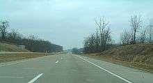
US 33 enters Ohio from Indiana, to the west, near Willshire in Van Wert County as a two-lane highway, continuing southeast through Mercer County, crossing US 127, then entering Auglaize County, joining limited-access Ohio Route 29 (SR 29) briefly near St. Marys, continuing east as a four-lane parkway, then a controlled-access highway near Wapakoneta, where it intersects Interstate 75 (I-75).
East of I-75, the road once again becomes two-lane as it continues to Lakeview and Russells Point south of Indian Lake. At the terminus of SR 117 near Huntsville, US 33 becomes a limited-access, multi-lane highway before reaching US 68 at Bellefontaine where it resumes as a controlled-access freeway, passing Campbell Hill, the highest point in Ohio, and continuing around Marysville. Entering Franklin County, the road runs concurrently with SR 161, then intersects I-270 in Dublin.
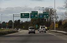
After I-270, the route loses its controlled-access status and passes though the Dublin Historic District and crosses the Scioto River. The overlap with SR 161 then ends, and US 33 heads south on Riverside Drive towards downtown Columbus, following the Scioto River along the western border of Upper Arlington, where it passes Griggs Reservoir, one of the main sources of water for Columbus. The road changes names two times in this area, first to Dublin Road at the intersection with Trabue Road, and then to Spring/Long Streets at SR 315. The route continues south on 3rd/4th Streets and then east on Livingston Avenue, heading towards the Columbus neighborhood of Driving Park.
In Bexley, US 33 veers southeast onto College Avenue, then intersects I-70. After Petzinger Road, the route becomes a controlled-access highway, subsequently intersecting SR 104, I-270 (for the second time), and SR 317 (Hamilton Road). Following the Ebright Road near Blacklick Estates, the highway continues to the southeast as a non-limited-access expressway.
Beginning at Carroll, US 33 bypasses Lancaster as a limited-access freeway completed in 2005.[2] Continuing southeast, the highway enters Ohio's scenic Hocking Hills region near Sugar Grove as an expressway. East of Logan, the highway again becomes limited-access for approximately 13 miles (21 km). As the route approaches Nelsonville, traffic continues on the limited access four-lane bypass that opened October 1, 2013.[3] Further southeast towards Athens, the expressway design resumes, followed by a brief limited-access section around Athens, where it joins the concurrent US 50/SR 32 for about three miles (4.8 km). South of Athens, US 33 continues as a limited-access highway, bypassing Pomeroy, intersecting SR 124 and SR 7, and continuing to the Ohio River in Meigs County, crossing the Ohio on the two-lane cantilever Ravenswood Bridge, and entering West Virginia in Ravenswood.
In total, US 33 traverses 236.8 miles (381.1 km) across the Buckeye State.
History
The Ravenswood Bridge was built in 1981 and originally carried the designation SR 824 until 2003, when US 33 was rerouted on a new bypass out of Pomeroy and connecting to the bridge, supplanting SR 824 in the process.[4]
In 2013, an expressway bypass was completed around Nelsonville. This was done to reduce traffic congestion in the area, as the original routing through Nelsonville was only two lanes wide.[5]
As of 2013, the route had an average of 73,000 vehicles per day.[5]
Major intersections
| County | Location | mi[1] | km | Exit | Destinations | Notes | ||
|---|---|---|---|---|---|---|---|---|
| Van Wert | Willshire Township | 0.00 | 0.00 | Indiana state line | ||||
| Willshire | 0.53 | 0.85 | Western end of SR 81 concurrency | |||||
| 0.75 | 1.21 | Eastern end of SR 81 concurrency; western end of SR 49 concurrency | ||||||
| 0.94 | 1.51 | Eastern end of SR 49 concurrency | ||||||
| Mercer | Rockford | 9.29 | 14.95 | Western end of SR 118 concurrency | ||||
| 9.81 | 15.79 | Eastern end of SR 118 concurrency | ||||||
| Dublin Township | 13.64 | 21.95 | Western end of SR 707 concurrency | |||||
| 14.16 | 22.79 | Eastern end of SR 707 concurrency | ||||||
| Neptune | 19.91 | 32.04 | ||||||
| Auglaize | St. Marys | 25.00 | 40.23 | Western end of expressway; interchange | ||||
| 27.25 | 43.85 | Interchange | ||||||
| Moulton Township | 31.60 | 50.86 | County Road 91 — Moulton | Interchange | ||||
| Wapakoneta | 35.15 | 56.57 | County Road 33A — Wapakoneta | Interchange | ||||
| 36.97 | 59.50 | Hardin Pike — Wapakoneta | Interchange | |||||
| 37.23 | 59.92 | Western terminus of SR 67; southern terminus of SR 198 and SR 501; interchange; former US 25 | ||||||
| 38.51 | 61.98 | Exit 110 on I-75 | ||||||
| 39.10 | 62.93 | Wapak Fisher Road – Fryburg | Eastern end of expressway | |||||
| Union Township | 43.02 | 69.23 | Western end of SR 65 concurrency | |||||
| 45.07 | 72.53 | Eastern end of SR 65 concurrency | ||||||
| New Hampshire | 49.95 | 80.39 | Southern terminus of SR 196; western terminus of SR 385 | |||||
| Logan | Stokes Township | 52.89 | 85.12 | Western terminus of SR 366 | ||||
| Lakeview | 55.22 | 88.87 | ||||||
| Russells Point | 56.58 | 91.06 | Eastern terminus of SR 720 | |||||
| 57.20 | 92.05 | |||||||
| Washington Township | 61.29 | 98.64 | ||||||
| 62.48 | 100.55 | Interchange; eastern terminus of SR 117 | ||||||
| Harrison Township | Western end of freeway | |||||||
| Bellefontaine | 67.18 | 108.12 | ||||||
| 68.72 | 110.59 | |||||||
| Jefferson Township | 71.39 | 114.89 | County Road 10 — Zanesfield, Bellefontaine | |||||
| 73.48 | 118.25 | |||||||
| Perry Township | 77.47 | 124.68 | ||||||
| Union | Allen Township | 81.81 | 131.66 | Western access to Marysville Auto Plant; southern terminus of SR 739 and eastern terminus of SR 287 | ||||
| 83.86 | 134.96 | Honda Parkway | East access to Marysville Auto Plant | |||||
| Paris Township | 89.01 | 143.25 | ||||||
| 89.51 | 144.05 | 89 | Western end of US 36 and SR 4 concurrencies | |||||
| Marysville | 91.51 | 147.27 | 91 | No access from US 33 west to SR 31 south | ||||
| 91.84 | 147.80 | 92 | Eastern end of SR 4 concurrency | |||||
| 93.35 | 150.23 | 93 | Eastern end of US 36 concurrency | |||||
| 96.00 | 154.50 | 96 | Scottslawn Road | |||||
| Jerome Township | 101.53 | 163.40 | ||||||
| Dublin | 106.05 | 170.67 | 106 | Western end of SR 161 concurrency | ||||
| Franklin | 107.58 | 173.13 | 107 | Avery-Muirfield Drive — Dublin | ||||
| 108.84 | 175.16 | 108 | Exit 17 on I-270; eastern end of freeway | |||||
| 109.98 | 177.00 | |||||||
| 110.19 | 177.33 | Southern terminus of SR 257; eastern end of SR 161 concurrency; roundabout | ||||||
| Columbus | 119.27 | 191.95 | I-670 exit 1A | |||||
| 121.47 | 195.49 | I-670 exit 2A | ||||||
| 121.66 | 195.79 | SR 315 exit 1C | ||||||
| 122.92 | 197.82 | Western end of US 23 overlap | ||||||
| 122.92 | 197.82 | Western end of SR 3 overlap | ||||||
| 123.11 | 198.13 | Western end of US 62 overlap | ||||||
| 123.44 | 198.66 | Eastern end of US 62 / SR 3 overlap | ||||||
| 123.72 | 199.11 | Eastern end of US 23 overlap | ||||||
| 123.74 | 199.14 | No access to northbound I-71; exit 100B on I-70 | ||||||
| 126.61 | 203.76 | I-70 exit 103B | ||||||
| 128.19 | 206.30 | 128A | Westbound exit and eastbound entrance; exit 105A on I-70 | |||||
| 128.9 | 207.4 | 128C | Westbound exit and eastbound entrance | |||||
| 129.1 | 207.8 | 128B | Winchester Pike | Eastbound exit and westbound entrance; interchange; western end of freeway | ||||
| 129.25 | 208.01 | 129 | Northern terminus of SR 104; signed as exits 129A (west) and 129B (east) westbound | |||||
| 131.03 | 210.87 | 131 | Exit 46 on I-270; signed as exits 131A (south) and 131B (north) | |||||
| 132.23 | 212.80 | 132 | ||||||
| Canal Winchester | 135.91 | 218.73 | 135 | Northern terminus of SR 674; interchange; eastern end of freeway | ||||
| Fairfield | Violet Township | 138.60 | 223.06 | Hill Road / Diley Road | Interchange | |||
| Carroll | 143 | Winchester Road | Projected completion May 31, 2017[6] | |||||
| Greenfield Township | 145.182 | 233.648 | 145 | Lancaster Business Route | Eastbound exit and westbound entrance | |||
| 146.272 | 235.402 | CR 31 — Lithopolis, Coonpath Road | Westbound exit and eastbound entrance | |||||
| Hocking Township | 150.282 | 241.855 | ||||||
| 152.552 | 245.509 | |||||||
| Berne Township | 158.162– 158.412 | 254.537– 254.939 | Lancaster Business Route, Tarklin Road | Lancaster Business Route signed westbound only | ||||
| Hocking | Good Hope Township | 162.012 | 260.733 | Northern terminus of SR 374 | ||||
| Falls Township | 166.972 | 268.715 | ||||||
| Logan | 170.292 | 274.058 | ||||||
| 172.232 | 277.181 | |||||||
| 174.172 | 280.303 | Northern terminus of SR 328 | ||||||
| Green Township | 177.222 | 285.211 | Southern terminus of SR 595 | |||||
| Athens |
No major junctions | |||||||
| Hocking | Ward Township | 182.072 | 293.016 | Nelsonville Business Route | To SR 278 | |||
| Athens | Nelsonville | 185.792 | 299.003 | Western terminus of SR 78 | ||||
| Dover Township | 191.882 | 308.804 | ||||||
| Athens | 194.082 | 312.345 | Southern terminus of SR 13; western terminus of SR 550 | |||||
| 196.362 | 316.014 | State Street — Athens | ||||||
| Athens Township | 196.852 | 316.803 | Stimson Avenue | Western end of US 50 and SR 32 concurrencies; full access to US 50/SR 32, eastbound exit and westbound entrance to Stimson Avenue only | ||||
| 197.292 | 317.511 | County Road 25, Stimson Avenue | Westbound entrance at US 50 exit | |||||
| Athens | 198.322 | 319.168 | Southern terminus of SR 682 | |||||
| 199.082– 199.122 | 320.391– 320.456 | Eastern end of US 50 and SR 32 concurrencies; separate exits eastbound for US 50/SR 32 and Richland Avenue | ||||||
| Meigs | Bedford Township | 211.302 | 340.058 | Grade separation | ||||
| Salisbury Township | 218.772– 218.792 | 352.079– 352.112 | Interchange; US 33 and SR 124 exchange carriageways; eastern terminus of SR 833; western end of SR 7 concurrency | |||||
| County Road 20, County Road 25 | Grade separation | |||||||
| 221.212 | 356.006 | Eastern end of SR 7 concurrency; eastern terminus of SR 733; eastern end of expressway | ||||||
| Sutton Township | 226.992 | 365.308 | County Road 28 | Grade separation | ||||
| Lebanon Township | 233.892 | 376.413 | ||||||
| 262.202 | 421.973 | County Road 338 | Former SR 338 | |||||
| Ohio River | 236.802 | 381.096 | Ravenswood Bridge; Ohio–West Virginia state line | |||||
| Continuation into West Virginia | ||||||||
1.000 mi = 1.609 km; 1.000 km = 0.621 mi
| ||||||||
See also


References
- 1 2 Ohio Department of Transportation (June 24, 2015). "Roadway Description Inventory Report: DESTAPE". Ohio Department of Transportation. Retrieved November 21, 2015.
- Van Wert County (PDF)
- Mercer County (PDF)
- Auglaize County (PDF)
- Logan County (PDF)
- Union County (PDF)
- Franklin County (PDF)
- Fairfield County (PDF)
- Hocking County (PDF)
- Athens County (PDF)
- Meigs County (PDF)
- ↑ Lane, Mary Beth (October 28, 2005). "Bypass Is a Smooth Move for Commuters on Rt. 33". The Columbus Dispatch.
- ↑ Lane, Mary Beth (October 2, 2013). "Rt. 33 Motorists Save Time as Nelsonville Bypass Opens". The Columbus Dispatch. Retrieved May 12, 2014.
- ↑ Ohio Department of Transportation (January 2003). Official Ohio Transportation Map (PDF) (Map) (2003–2004 ed.). c. 1:570,240. Columbus: Ohio Department of Transportation. OCLC 5673562, 31884639. Retrieved August 20, 2013.
- 1 2 Ohio Department of Transportation. "U.S. Route 33 Nelsonville Bypass Opens Ahead of Schedule" (Press release). Ohio Department of Transportation. Archived from the original on April 15, 2013. Retrieved May 24, 2016.
- ↑ Ohio Department of Transportation. "The US 33 Carroll Interchange Project". Ohio Department of Transportation. Retrieved May 25, 2016.
External links

| Previous state: Indiana |
Ohio | Next state: West Virginia |