Ohio State Route 66
| ||||
|---|---|---|---|---|
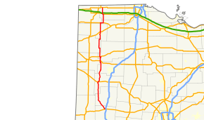 Route of SR 66 highlighted in red | ||||
| Route information | ||||
| Maintained by ODOT | ||||
| Length | 118.60 mi[1] (190.87 km) | |||
| Existed | 1924 – present | |||
| Major junctions | ||||
| South end |
| |||
|
| ||||
| North end |
| |||
| Location | ||||
| Counties | Miami, Shelby, Auglaize, Allen, Van Wert, Putnam, Paulding, Defiance, Williams, Henry, Fulton | |||
| Highway system | ||||
| ||||

State Route 66 (SR 66) is a north–south state highway in the northwestern portion of the U.S. state of Ohio. Its southern terminus is at US 36 in Piqua, and its northern terminus is at US 20 in Fayette. South of Defiance it generally follows the route of the former Miami and Erie Canal.
Route description
The portion of SR 66 between Washington Avenue in Piqua and the Miami/Shelby County line is designated as the "Cpl. Samuel F. Pearson Memorial Highway",[2] in honor of a Piqua High School graduate who was killed at Camp Victory in Baghdad, Iraq, while serving in the Army Reserve, on October 10, 2007.[3][4]
History
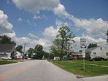
SR 66 through Spencerville
Major junctions
| County | Location | mi[1] | km | Destinations | Notes |
|---|---|---|---|---|---|
| Miami | Piqua | 0.00 | 0.00 | Southern terminus; road continues as US 36 west (Spring Street south) | |
| Shelby | Loramie Township | 10.78 | 17.35 | Northern terminus of SR 48 | |
| Cynthian Township | 12.44 | 20.02 | |||
| Fort Loramie | 16.68 | 26.84 | |||
| 16.80 | 27.04 | Southern terminus of SR 362 | |||
| Auglaize | Minster | 19.20 | 30.90 | Northern terminus of SR 362 | |
| 19.70 | 31.70 | Southern end of SR 119 concurrency | |||
| 20.71 | 33.33 | Northern end of SR 119 concurrency | |||
| New Bremen | 22.75 | 36.61 | |||
| Saint Marys Township | 26.80 | 43.13 | |||
| St. Marys | 30.19 | 48.59 | Southern end of SR 29 concurrency; southern terminus of SR 116; eastern terminus of SR 703 | ||
| 30.55 | 49.17 | Northern end of SR 29 concurrency | |||
| Noble Township | 31.34– 31.56 | 50.44– 50.79 | Interchange | ||
| Salem Township | 39.04 | 62.83 | |||
| Allen | Spencerville | 42.87 | 68.99 | ||
| Spencer–Amanda township line | 44.97 | 72.37 | Southern end of SR 81 concurrency | ||
| Amanda Township | 45.21 | 72.76 | Northern end of SR 81 concurrency | ||
| Delphos | 52.89 | 85.12 | Southern end of SR 697 concurrency | ||
| 53.12 | 85.49 | Northern end of SR 697 concurrency | |||
| Van Wert | Washington Township | 55.38– 55.50 | 89.13– 89.32 | Interchange | |
| Putnam | Ottoville | 59.90 | 96.40 | Southern end of US 224 concurrency; western terminus of SR 189 | |
| Monterey Township | 60.98 | 98.14 | Northern end of US 224 concurrency | ||
| Paulding | Washington Township | 67.10 | 107.99 | ||
| Brown Township | 73.17 | 117.76 | Southern end of SR 613 concurrency | ||
| Oakwood | 73.39 | 118.11 | Northern end of SR 613 concurrency | ||
| Auglaize Township | 80.46 | 129.49 | Northern terminus of SR 637 | ||
| Defiance | Defiance | Southern terminus of SR 66 Truck | |||
| 88.10 | 141.78 | Southern end of SR 15/SR 18 concurrency | |||
| 88.73 | 142.80 | Northern terminus of SR 66 Truck; former SR 111 | |||
| 88.87 | 143.02 | Northern end of SR 15/SR 18 concurrency | |||
| 89.67– 89.77 | 144.31– 144.47 | Interchange; exit 26 on US 24 | |||
| Williams | Springfield Township | 98.71 | 158.86 | Southern end of US 6 concurrency | |
| Henry | Ridgeville Township | 101.85 | 163.91 | Northern end of US 6 concurrency | |
| 102.52 | 164.99 | ||||
| Fulton | Archbold | 107.35 | 172.76 | Southern end of SR 2 concurrency | |
| German Township | 108.85 | 175.18 | Northern end of SR 2 concurrency | ||
| 110.85 | 178.40 | Southern end of US 20A concurrency | |||
| 111.97 | 180.20 | Northern end of US 20A concurrency | |||
| Franklin Township | 112.71 | 181.39 | Exit 25 on the Ohio Tpk. | ||
| Fayette | 118.60 | 190.87 | Northern terminus; road continues as Fayette Street | ||
1.000 mi = 1.609 km; 1.000 km = 0.621 mi
| |||||
References
- 1 2 "DESTAPE". Ohio Department of Transportation. July 3, 2014. Retrieved September 22, 2014.
- ↑ "5533.605 Cpl. Samuel F. Pearson Memorial Highway". Ohio Revised Code. LAW Writer. April 7, 2009. Retrieved May 24, 2014.
- ↑ Staff (May 25, 2009). "Route 66 Renamed In Honor Of Fallen Soldier". WHIO-TV. Retrieved May 24, 2014.
- ↑ Archdeacon, Tom (May 17, 2014). "Arch: Piqua's Pearson gone but not forgotten". Dayton Daily News. Retrieved May 24, 2014.
- ↑ Explanation of the Ohio State Highway System (The Unofficial Ohio State Highways Web Site) by John Simpson Archived May 23, 2006, at the Wayback Machine.
- 1 2 Route 66 (The Unofficial Ohio State Highways Web Site) by John Simpson Archived December 23, 2004, at the Wayback Machine.
External links
Route map:
| Wikimedia Commons has media related to Ohio State Route 66. |
This article is issued from
Wikipedia.
The text is licensed under Creative Commons - Attribution - Sharealike.
Additional terms may apply for the media files.