Wapakoneta, Ohio
| Wapakoneta, Ohio | ||
|---|---|---|
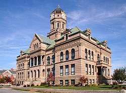
 Wapakoneta City Hall | ||
| ||
| Nickname(s): Home of the First Man on the Moon, Home of Neil Armstrong, Moon City | ||
 Location of Wapakoneta, Ohio | ||
 Location of Wapakoneta in Auglaize County | ||
 Wapakoneta, Ohio Location in U.S. | ||
| Coordinates: 40°34′33″N 84°11′34″W / 40.57583°N 84.19278°WCoordinates: 40°34′33″N 84°11′34″W / 40.57583°N 84.19278°W | ||
| Country | United States | |
| State | Ohio | |
| County | Auglaize | |
| Founded | 1782 | |
| Incorporated | March 2, 1849 | |
| Government | ||
| • Mayor | Thomas A. Stinebaugh (R) | |
| Area[1] | ||
| • Total | 6.26 sq mi (16.21 km2) | |
| • Land | 6.21 sq mi (16.08 km2) | |
| • Water | 0.05 sq mi (0.13 km2) | |
| Elevation | 895 ft (272 m) | |
| Population (2010)[2] | ||
| • Total | 9,867 | |
| • Estimate (2012[3]) | 9,824 | |
| • Density | 1,588.9/sq mi (613.5/km2) | |
| Time zone | UTC-5 (EST) | |
| • Summer (DST) | UTC-4 (EDT) | |
| ZIP codes | 45895 | |
| Area code(s) | 419, 567 | |
| FIPS code | 39-80766[4] | |
| GNIS feature ID | 1070980[5] | |
| Website | http://www.wapakoneta.net | |

Wapakoneta, pronounced Waw-paw-ko-net-a (as in about; locally [ˌwɒpəkəˈnɛɾə]) is a city in and the county seat of Auglaize County,[6] Ohio, United States approximately 56 mi (90 km) north of Dayton and 83 mi (133 km) SW of Toledo. The population was 9,867 at the 2010 census. It is the principal city of and is included in the Wapakoneta, Ohio Micropolitan S A, which is included in the Lima-Van Wert-Wapakoneta, Ohio CSA. The community is served by the Wapakoneta City School District.
The city is the birthplace of astronaut Neil Armstrong, the first man to set foot on the moon.
Wapakoneta is a sister city to Lengerich, North Rhine-Westphalia, Germany. Lengerich's neighboring municipalities, Ladbergen and Lienen, are sister cities with Wapakoneta's neighbors New Knoxville and Saint Marys, respectively.
Geography
According to the United States Census Bureau, the city has a total area of 6.26 square miles (16.21 km2), of which 6.21 square miles (16.08 km2) is land and 0.05 square miles (0.13 km2) is water.[1]
Wapakoneta is located on the Auglaize River and includes portions of Duchouquet, Pusheta, and Moulton Townships.
Demographics
| Historical population | |||
|---|---|---|---|
| Census | Pop. | %± | |
| 1850 | 504 | — | |
| 1860 | 900 | 78.6% | |
| 1870 | 2,150 | 138.9% | |
| 1880 | 2,705 | 25.8% | |
| 1890 | 3,616 | 33.7% | |
| 1900 | 3,915 | 8.3% | |
| 1910 | 5,349 | 36.6% | |
| 1920 | 5,295 | −1.0% | |
| 1930 | 5,378 | 1.6% | |
| 1940 | 5,225 | −2.8% | |
| 1950 | 5,797 | 10.9% | |
| 1960 | 6,756 | 16.5% | |
| 1970 | 7,324 | 8.4% | |
| 1980 | 8,402 | 14.7% | |
| 1990 | 9,214 | 9.7% | |
| 2000 | 9,474 | 2.8% | |
| 2010 | 9,867 | 4.1% | |
| Est. 2017 | 9,782 | [7] | −0.9% |
| Sources:[4][8][9][10][11][12][13][14] | |||
2010 census
As of the census[2] of 2010, there were 9,867 people, 4,037 households, and 2,614 families residing in the city. The population density was 1,588.9 inhabitants per square mile (613.5/km2). There were 4,332 housing units at an average density of 697.6 per square mile (269.3/km2). The racial makeup of the city was 97.1% White, 0.4% African American, 0.3% Native American, 0.4% Asian, 0.6% from other races, and 1.2% from two or more races. Hispanic or Latino of any race were 1.6% of the population.
There were 4,037 households of which 32.6% had children under the age of 18 living with them, 46.7% were married couples living together, 12.8% had a female householder with no husband present, 5.3% had a male householder with no wife present, and 35.2% were non-families. 30.5% of all households were made up of individuals and 13.1% had someone living alone who was 65 years of age or older. The average household size was 2.39 and the average family size was 2.95.
The median age in the city was 37 years. 25.2% of residents were under the age of 18; 8.6% were between the ages of 18 and 24; 26% were from 25 to 44; 24.4% were from 45 to 64; and 15.6% were 65 years of age or older. The gender makeup of the city was 47.8% male and 52.2% female.
2000 census
As of the census[4] of 2000, there were 9,474 people, 3,803 households, and 2,540 families residing in the city. The population density was 1,674.7 people per square mile (646.3/km²). There were 4,057 housing units at an average density of 717.2 per square mile (276.8/km²). The racial makeup of the city was 97.96% White, 0.19% African American, 0.26% Native American, 0.39% Asian, 0.05% Pacific Islander, 0.37% from other races, and 0.77% from two or more races. Hispanic or Latino of any race were 0.87% of the population.
There were 3,803 households out of which 33.1% had children under the age of 18 living with them, 51.4% were married couples living together, 11.2% had a female householder with no husband present, and 33.2% were non-families. 28.9% of all households were made up of individuals and 11.9% had someone living alone who was 65 years of age or older. The average household size was 2.43 and the average family size was 2.99.
In the city the population was spread out with 26.2% under the age of 18, 9.7% from 18 to 24, 28.4% from 25 to 44, 20.2% from 45 to 64, and 15.6% who were 65 years of age or older. The median age was 35 years. For every 100 females, there were 89.7 males. For every 100 females age 18 and over, there were 85.9 males.
The median income for a household in the city was $38,531, and the median income for a family was $45,456. Males had a median income of $34,523 versus $23,478 for females. The per capita income for the city was $18,976. About 8.4% of families and 8.9% of the population were below the poverty line, including 11.6% of those under age 18 and 9.3% of those age 65 or over.
Sister cities
Wapakoneta has one sister city, as designated by the Sister Cities International:

Education
Wapakoneta is home to Wapakoneta High School. The city has a public library, the main branch of the Auglaize County Public Library.[15]
Notable people
- Neil Armstrong, astronaut for NASA, first man on the Moon
- Charles Brading, pharmacist and politician
- Jennifer Crusie, romance novel writer
- George Russell Davis, Associate Justice of the Arizona Territorial Supreme Court
- Bob Ewing, Major League Baseball player
- Dan Newland, journalist, translator, and writer
- Dudley Nichols, Oscar-winning screenwriter
- Robert Henderson (Author, Pastoral Psychotherapist)
- Kent Boyd, Dancer, Runner-Up SYTYCD
- In the film Third Finger, Left Hand (1940), the Melvyn Douglas character is from Wapakoneta, and the film ends at the Wapakoneta railroad station.
As the birthplace of Neil Armstrong, there are several places named after him in Wapakoneta, such as the Neil Armstrong Air and Space Museum, operated by the Ohio Historical Society. The Auglaize County airport is called the Neil Armstrong Airport.
See also
References
- 1 2 "US Gazetteer files 2010". United States Census Bureau. Archived from the original on 2012-01-24. Retrieved 2013-01-06.
- 1 2 "American FactFinder". United States Census Bureau. Retrieved 2013-01-06.
- ↑ "Population Estimates". United States Census Bureau. Archived from the original on 2013-06-17. Retrieved 2013-06-17.
- 1 2 3 "American FactFinder". United States Census Bureau. Retrieved 2008-01-31.
- ↑ "US Board on Geographic Names". United States Geological Survey. 2007-10-25. Retrieved 2008-01-31.
- ↑ "Find a County". National Association of Counties. Retrieved 2011-06-07.
- ↑ "Population and Housing Unit Estimates". Retrieved May 26, 2018.
- ↑ "Population of Civil Divisions Less than Counties" (PDF). Statistics of the Population of the United States at the Tenth Census. U.S. Census Bureau. Retrieved 28 November 2013.
- ↑ "Population of Civil Divisions Less than Counties" (PDF). Statistics of the Population of the United States at the Tenth Census. U.S. Census Bureau. Retrieved 28 November 2013.
- ↑ "Population: Ohio" (PDF). 1910 U.S. Census. U.S. Census Bureau. Retrieved 28 November 2013.
- ↑ "Population: Ohio" (PDF). 1930 US Census. U.S. Census Bureau. Retrieved 28 November 2013.
- ↑ "Number of Inhabitants: Ohio" (PDF). 18th Census of the United States. U.S. Census Bureau. Retrieved 22 November 2013.
- ↑ "Ohio: Population and Housing Unit Counts" (PDF). U.S. Census Bureau. Retrieved 22 November 2013.
- ↑ "Incorporated Places and Minor Civil Divisions Datasets: Subcounty Population Estimates: April 1, 2010 to July 1, 2012". U.S. Census Bureau. Archived from the original on 17 June 2013. Retrieved 25 November 2013.
- ↑ "Hours & Locations". Auglaize County Libraries. Retrieved 25 February 2018.
External links
- City Website
- Wapakoneta Area Economic Development Council
- Wapakoneta Area Chamber of Commerce
- Wapakoneta Daily News
Municipalities and communities of Auglaize County, Ohio, United States | ||
|---|---|---|
| Cities | 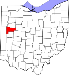 | |
| Villages | ||
| Townships | ||
| CDPs | ||
| Unincorporated communities | ||
| Ghost towns |
| |
| Footnotes | ‡This populated place also has portions in an adjacent county or counties | |