U.S. Route 101 in Washington
| ||||
|---|---|---|---|---|
|
Map of western Washington with US 101 highlighted in red | ||||
| Route information | ||||
| Maintained by WSDOT | ||||
| Length | 365.55 mi[1] (588.30 km) | |||
| Existed | 1926–present | |||
| Tourist routes | Lewis and Clark Highway | |||
| Major junctions | ||||
| South end |
| |||
| North end |
| |||
| Location | ||||
| Counties | Pacific, Grays Harbor, Jefferson, Clallam, Mason, Thurston | |||
| Highway system | ||||
| ||||

U.S. Route 101 (US 101) is a United States Numbered Highway that runs along the Pacific Coast from Los Angeles, California to Tumwater, Washington. Within the state of Washington, US 101 connects cities on the coast of the Pacific Ocean and encircles the Olympic Peninsula around the Olympic Mountains and Olympic National Park.
The highway enters from Oregon on the Astoria–Megler Bridge over the mouth of the Columbia River near Astoria, Oregon. From there, it runs for 365 miles (587 km) north through Ilwaco, Raymond, Aberdeen, Hoquiam, and Forks before turning east towards Port Angeles. US 101 turns south near Discovery Bay and continues along the Hood Canal through Shelton towards Olympia, where it becomes a freeway and terminates at Interstate 5 (I-5) in Tumwater.
Route description
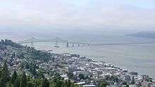

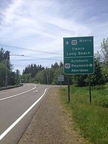
US 101 enters Washington from Oregon on the Astoria–Megler Bridge, a four-mile (6 km) bridge that carries vehicles across the Columbia River near its mouth; it is the longest continuous truss bridge in North America and among the longest of its kind in the world.[2] At the north end of the bridge is an intersection with State Route 401 (SR 401), where US 101 turns west to follow the north bank of the river, forming part of the Lewis and Clark Trail Scenic Byway. The highway passes under Fort Columbia State Park in a tunnel and continues along the Willapa Hills through Chinook towards Baker Bay. At the head of the bay, near Port of Ilwaco Airport, US 101 intersects a short alternate route that bypasses the coastal section of the highway. US 101 then dives southwesterly along the Wallacut River into Ilwaco, where it runs through town as Spruce Street before turning north onto 1st Avenue after an intersection with SR 100.[3]
From Ilwaco, US 101 travels northwest into Seaview, where it intersects SR 103 at the foot of Long Beach and turns east onto 40th Street. The highway intersects the north end of the alternate route and crosses northeast over the Bear River and enters the Willapa National Wildlife Refuge. US 101 continues north along the east side of Willapa Bay and crosses the Naselle River before turning east towards Johnston's Landing, where SR 4 terminates.
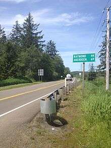
Soon, US 101 turns north towards Raymond. In Raymond, US 101 intersects the western end of SR 6 and southern end of SR 105, which it will intersect again in Cosmopolis.
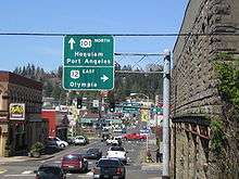
After intersecting with SR 105 and SR 107, US 101 crosses the Chehalis River, which leads the highway to the western end of US 12 in Aberdeen. The roadway turns southwest and splits into two streets for each direction until it reaches Hoquiam, where it intersects the southern end of SR 109 and the eastern end of SR 109 Spur.
US 101 then turns north to the Quinault Indian Reservation and then into the isolated area bordered by Olympic National Park and the Quinault Indian Reservation. After turning east at Lake Quinault and entering the Quinault Indian Reservation again, US 101 goes north to the Olympic National Park on the Pacific coast.
The road then curves north to Forks and north to Beaver, where it turns east after intersecting with SR 113 and touching the shore of Lake Pleasant. After a mile of going east, US 101 enters its second segment in the Olympic National Park, about one-mile (1.6 km) east of the west shore of Lake Crescent and then exits at the eastern shore of the same lake.
After exiting park boundaries, US 101 intersects SR 112. Shortly later, it intersects SR 117 (the Tumwater Truck Route) in an odd interchange/intersection hybrid. It then enters Port Angeles and turns onto Lincoln Street. It then turns onto a one-way couplet of First and Front streets, which lasts until Golf Course Road. There, the roads merge into one four-lane road, divided only by a two-way left turn lane, and leaves Port Angeles.
Following the dangerous Morse Creek S-Curves is a Rest Area and viewpoint at the Deer Park Loop interchange. The road then becomes a divided expressway until it reaches Carlsborg and crosses the Dungeness River. It enters the town of Sequim and turns into a super-two expressway, bypassing the town. East of Sequim, the road turns back into a standard two-lane road and goes to Sequim Bay and then Discovery Bay, where it intersects SR 20 and turns south. After a short distance, US 101 intersects the western end of SR 104. The road then turns south to the town of Quilcene. Exiting Quilcene, the road heads southwest into Olympic National Forest and crosses a 227 m (744 ft 9 in) pass between Mount Walker and Buck Mountain, after which it proceeds sharply downhill southeast towards Dabob Bay, where it continues following the shore and reaches Hood Canal.
At the Hood Canal, US 101 follows the western shore to SR 106, where it turns directly south to the east end of SR 106 and Shelton, to meet the west end of SR 3. After some time going south, US 101 meets SR 108, the second-to-last major junction. After going southeast, US 101 finally joins SR 8 and turns into a freeway to its easternmost point of US 101 in Washington, the so-called "north end" at I-5 near Tumwater.[3]
History
Before U.S. Route 101 was created, two roads existed in the place of US 101. They were State Road 9 and State Road 12. These were two roads that were part of the early Washington State Road system that was created in 1923. US 101 was created in 1926 and was co-signed with these two routes. US 101 took part of State Road 9's route and part of State Road 12's route.
In 1937, the Washington State Legislature established a new system, the Primary and secondary system.[4] State Road 9 became Primary State Highway 9 or PSH 9. State Road 12 became PSH 12, and they both held the co-signed designation with US 101.[5]
There was nothing changed about US 101's route from 1937 to 1956. In 1956, President Dwight D. Eisenhower signed the Interstate Highway Act into law. This eliminated part of the U.S. Route system and encouraged Washington's Legislature to once again change the highway system.
In January 1964, the Washington State Legislature and the Washington Department of Highways (renamed WSDOT) approved a new state route system with no branches or secondary route with names, but a full system that lives on today. PSH 9 and PSH 12 became part of U.S. Route 101 with no co-designation and parts of them became other new state routes.[6]
Major intersections
| County | Location | mi[1] | km | Destinations | Notes | |||
|---|---|---|---|---|---|---|---|---|
| Columbia River | 0.00– 0.44 | 0.00– 0.71 | Astoria–Megler Bridge | |||||
| Pacific | Megler | 0.46 | 0.74 | |||||
| Ilwaco | 9.41 | 15.14 | ||||||
| 11.57 | 18.62 | |||||||
| Seaview | 13.38 | 21.53 | ||||||
| | 15.75 | 25.35 | ||||||
| Johnston's Landing | 28.89 | 46.49 | ||||||
| Raymond | 58.48 | 94.11 | ||||||
| 59.40 | 95.60 | |||||||
| Grays Harbor | | 76.69 | 123.42 | |||||
| Aberdeen | 82.67 | 133.04 | ||||||
| 82.82 | 133.29 | |||||||
| 83.27 | 134.01 | State Avenue | Interchange, northbound exit and southbound entrance | |||||
| 83.37– 83.43 | 134.17– 134.27 | |||||||
| Hoquiam | 87.26 | 140.43 | ||||||
| 88.62 | 142.62 | |||||||
| Jefferson |
No major junctions | |||||||
| Grays Harbor |
No major junctions | |||||||
| Jefferson |
No major junctions | |||||||
| Clallam | Forks | 192.54 | 309.86 | |||||
| Sappho | 203.28 | 327.15 | ||||||
| | 241.89 | 389.28 | ||||||
| Port Angeles | 245.38 | 394.90 | Interchange, northbound exit and southbound entrance | |||||
| 248.09 | 399.26 | Race Street | Former SR 111 | |||||
| West end of limited access | ||||||||
| Sequim | 262.29 | 422.11 | River Road – Sequim City Center | Interchange | ||||
| 263.80 | 424.54 | Sequim Avenue – Sequim City Center | Interchange | |||||
| 265.36 | 427.06 | Simdars Road / Washington Street – Sequim City Center | Northbound entrance and southbound exit | |||||
| East end of limited access | ||||||||
| Jefferson | Discovery Bay | 281.60 | 453.19 | |||||
| | 283.17 | 455.72 | Interchange | |||||
| Mason | Hoodsport | 330.77 | 532.32 | |||||
| Skokomish | 336.03 | 540.79 | ||||||
| | 342.47 | 551.15 | ||||||
| North end of limited access | ||||||||
| Shelton | 344.15 | 553.86 | Wallace Kneeland Boulevard | |||||
| 345.85 | 556.59 | Shelton-Matlock Road – Shelton City Center, Matlock | ||||||
| | 348.21 | 560.39 | ||||||
| Kamilche | 351.77 | 566.12 | ||||||
| Thurston | | 358.08 | 576.27 | Steamboat Island Road – Steamboat Island | ||||
| | 359.66 | 578.82 | Northbound entrance and southbound exit | |||||
| | 360.74 | 580.55 | 2nd Avenue SW | |||||
| | 362.10 | 582.74 | Evergreen Parkway – The Evergreen State College | Northbound entrance and southbound exit | ||||
| Olympia | 363.59 | 585.14 | Black Lake Boulevard – West Olympia | |||||
| 364.57 | 586.72 | Cooper Point Road / Crosby Boulevard | ||||||
| Tumwater | 365.56 | 588.31 | Northern terminus | |||||
| 1.000 mi = 1.609 km; 1.000 km = 0.621 mi | ||||||||
Special routes
Ilwaco alternate
| |
|---|---|
| Location | Ilwaco, Washington |
| Existed | 1931–present |
U.S. Route 101 Alternate is a 0.61-mile[1] (0.98 km) bypass of Ilwaco. US 101 Alt. opened in 1931 as a branch of PSH 12, the early designation of the southern section of US 101 through Washington. The highway was not fully recognized by the AASHTO until October 2006, even though many maps from the 1930s state that it is part of the U.S. Route system.[7][8]
References
- 1 2 3 Multimodal Planning Division (January 3, 2018). State Highway Log Planning Report 2017, SR 2 to SR 971 (PDF) (Report). Washington State Department of Transportation. pp. 796–879. Retrieved June 23, 2018.
- ↑ Read, Richard (December 27, 2015). "Astoria-Megler Bridge straddles 4 miles, guides ship pilots, withstands gusts". The Oregonian. Retrieved June 23, 2018.
- 1 2 Google (June 23, 2018). "U.S. Route 101, Washington" (Map). Google Maps. Google. Retrieved June 23, 2018.
- ↑ "Highways of Washington State- PSH". Retrieved April 3, 2008.
- ↑ "Highways of Washington State- PSH 12". Retrieved April 3, 2008.
- ↑ "Highways of Washington State- PSH 9". Retrieved April 3, 2008.
- ↑ "Highways of Washington State- US 101". Retrieved April 3, 2008.
- ↑ Google (May 27, 2008). "US 101 Alt" (Map). Google Maps. Google. Retrieved May 27, 2008.
External links
| Wikimedia Commons has media related to U.S. Route 101 in Washington (state). |
| Previous state: Oregon |
Washington | Next state: Terminus |