List of Interstate Highways in Washington
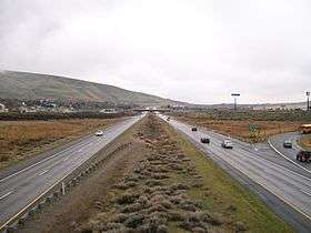
   Markers for I-5, I-90, and I-182 | |
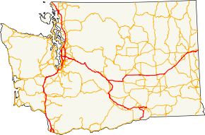 Map of highways in Washington with the Interstates highlighted in red | |
| System information | |
|---|---|
| Length | 764.27 mi (1,229.97 km) |
| Formed | June 29, 1956 |
| Highway names | |
| Interstates | Interstate nn (I‑nn) |
| Business Loops: | Business Loop Interstate nn (BL I‑nn) |
| Business Spurs: | Business Spur Interstate nn (BS I‑nn) |
| System links | |
The Interstate Highways in Washington is a group of seven designated Interstate Highways within the state of Washington in the Pacific Northwest region of the United States. The highways, totaling 764 miles (1,230 km) and spanning the state,[n 1] are owned and maintained by the Washington State Department of Transportation. They were designated and primarily funded by the federal government, with road standards and numbering handled by the Federal Highway Administration (FHWA) and the American Association of State Highway and Transportation Officials (AASHTO)
These highways connect every city in the state with a population of over 100,000 (Seattle, Spokane, Tacoma, Vancouver, Bellevue, and Everett)[1] as well as the state capital, Olympia.
Interstate 90 (I-90) is the longest primary Interstate Highway in Washington, which connects Seattle to Spokane and the Idaho border, measuring 297.52 mi (478.81 km), while I-82, connecting the Oregon border city of Umatilla to Elensburg via Yakima, is the shortest at 132.57 mi (213.35 km). The longest auxiliary Interstate Highway in Washington is I-405, a bypass of Seattle through the Eastside, at 30.30 mi (48.76 km), and the shortest is I-705, a spur into downtown Tacoma, at 1.50 mi (2.41 km). One route, I-605, has been proposed over the years to form another Eastside bypass, however there are no plans to construct this fifth auxiliary route.
Primary Interstate Highways

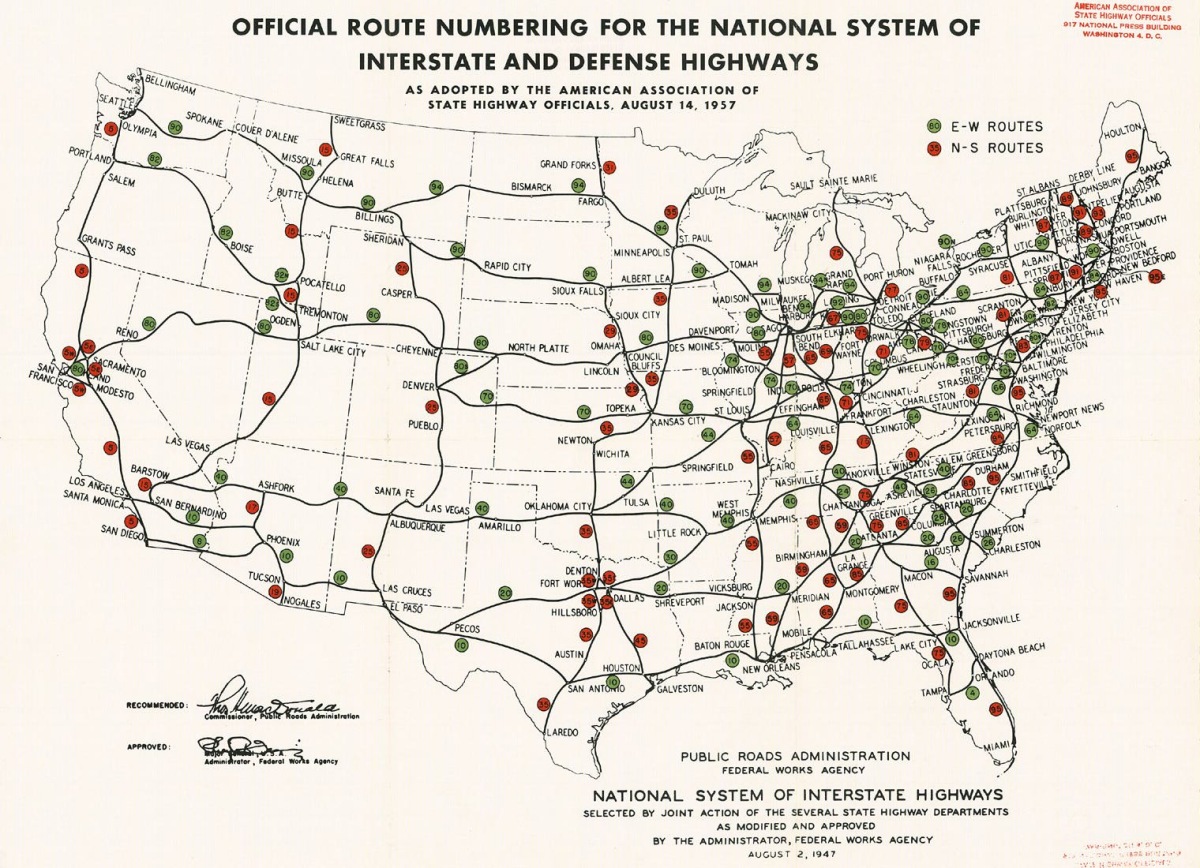
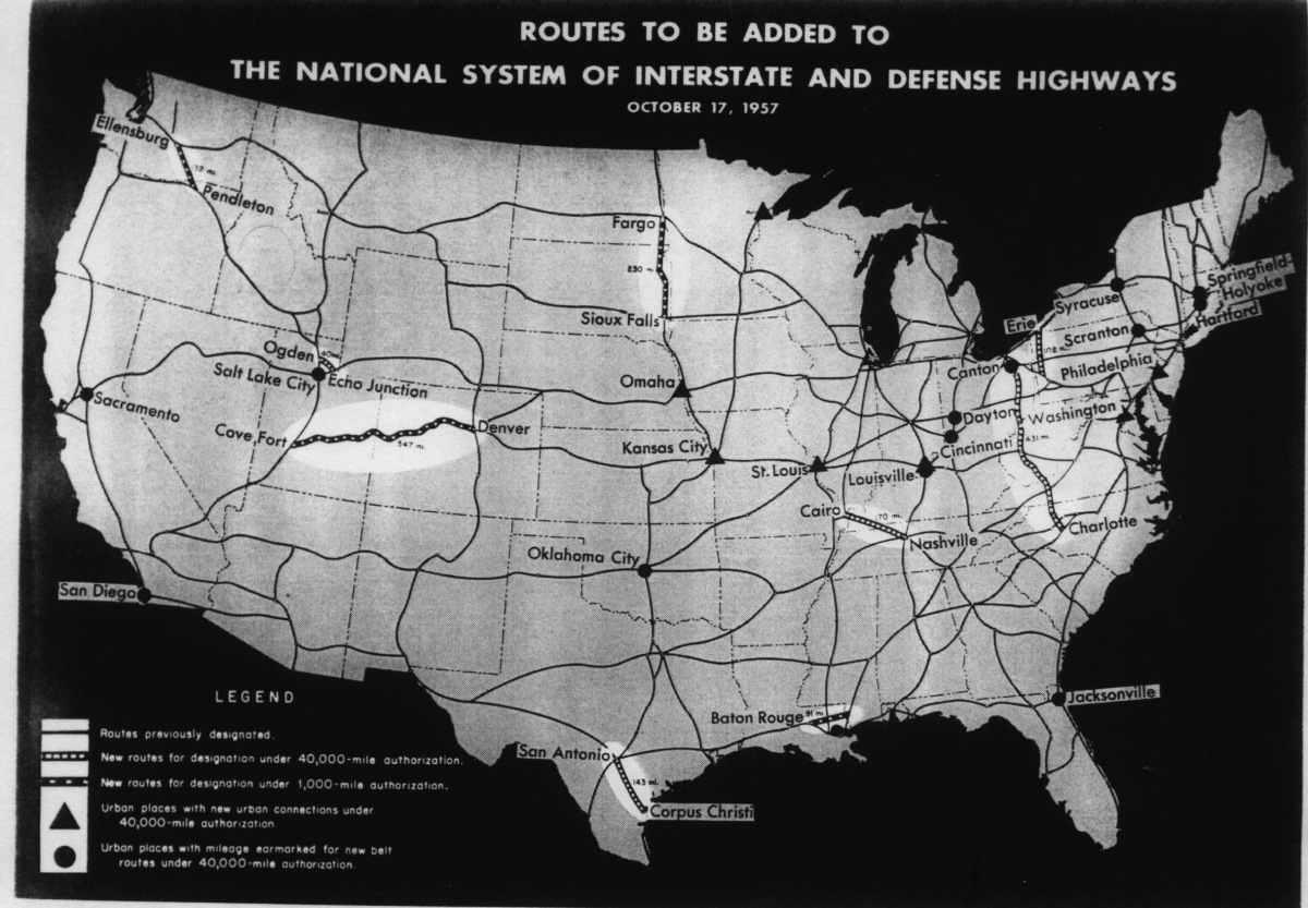
After passage of the Federal Aid Highway Act of 1956, which formed the Interstate Highway System,[2] the American Association of State Highway Officials had approved I-5 and I-90 across Washington on August 17, 1957.[3] I-82 was approved on October 17, 1957, two months after I-5 and I-90,[4] as part of a 1,102-mile-long (1,773 km) addition to the Interstate Highway System.[5]
| Number | Length (mi)[6] | Length (km) | Southern or western terminus | Northern or eastern terminus | Formed | Removed |
|---|---|---|---|---|---|---|
| 276.62 | 445.18 | I-5 at the Oregon state line | Hwy 99 at the Canada–United States border | 1957 | current | |
| 132.57 | 213.35 | I-90 in Ellensburg | I-82 at the Oregon state line | 1957 | current | |
| 297.52 | 478.81 | SR 519 in Seattle | I-90 at the Idaho state line | 1957 | current |
Auxiliary Interstate Highways
I-205 and I-405 were first codified into Washington State Law in 1970,[7][8] and I-182 and I-705 were codified in 1979.[9][10]
I-705 was completed in 1990,[11] after a series of federal budget cuts,[12] and was the last Interstate Highway to be completed in the state of Washington.[13]
| Number | Length (mi)[6] | Length (km) | Southern or western terminus | Northern or eastern terminus | Formed | Removed | ||
|---|---|---|---|---|---|---|---|---|
| 15.19 | 24.45 | I-82 / US 12 near Richland | US 12 / US 395 in Pasco | c. 1972 | current | |||
| 10.57 | 17.01 | I-205 at the Oregon state line | I-5 in Salmon Creek | c. 1975 | current | |||
| 30.30 | 48.76 | I-5 / SR 518 in Tukwila | I-5 / SR 525 in Lynnwood | 1964 | current | |||
| — | — | To be determined | To be determined | proposed | — | |||
| 1.50 | 2.41 | I-5 / SR 7 in Tacoma | Schuster Parkway in Tacoma | 1990 | current | |||
| ||||||||
See also


Footnotes
Notes
- ↑ The mileage is a sum of the lengths listed and cited on this page.
References
- ↑ Staff (2010). Census Redistricting Data (Public Law 94-171) Summary File (Zip) (Report). Washington State Office of Financial Management and U.S. Census Bureau. Retrieved December 24, 2013.
- ↑ Lewis, Tom (1997). Divided Highways: Building the Interstate Highways, Transforming American Life. New York: Viking. pp. 120–1, 136–7. ISBN 0-670-86627-X.
- ↑ Official Route Numbering for the National System of Interstate and Defense Highways as Adopted by the American Association of State Highway Officials (Map). Scale not given. Cartography by Public Roads Administration. Public Roads Administration. August 14, 1957. Retrieved January 20, 2014.
- ↑ Routes to be Added to the National System of Interstate and Defense Highways (Map). Scale not given. Cartography by Public Roads Administration. Public Roads Administration. October 17, 1957. Retrieved January 20, 2014.
- ↑ Mooney, Richard E. (October 19, 1957). "1,102 Miles Added To U.S. Roads Plan". The New York Times. p. 1. Retrieved 20 January 2014 – via ProQuest. (Subscription required (help)).
- 1 2 Finch, Mark (2012). State Highway Log: SR 2 to SR 971 (PDF) (Report). Washington State Department of Transportation. Retrieved January 2, 2014.
- ↑ "47.17.400: State route No. 205". Revised Code of Washington. Washington State Legislature. 1970. Retrieved January 20, 2014.
- ↑ "47.17.595: State route No. 405". Revised Code of Washington. Washington State Legislature. 1970. Retrieved January 20, 2014.
- ↑ "47.17.372: State route No. 182". Revised Code of Washington. Washington State Legislature. 1979. Retrieved January 20, 2014.
- ↑ "47.17.819: State route No. 705". Revised Code of Washington. Washington State Legislature. 1979. Retrieved January 20, 2014.
- ↑ Virgin, Bill (October 26, 2006). "At 50, interstates feeling their age". Seattle Post-Intelligencer. Hearst Corporation. Archived from the original on November 9, 2006. Retrieved March 4, 2017.
- ↑ Harper, Robert (April 16, 1980). "12 State Road Projects Budget Casualties". The Spokesman-Review. Spokane, Washington: Cowles Publishing Company. p. A2. Retrieved January 8, 2011.
- ↑ Nelson, Robert T. (March 29, 1998). "In the 6th District, Dicks Keeps Delivering". The Seattle Times. Retrieved January 8, 2011.
External links
| Wikimedia Commons has media related to Interstate Highways in Washington (state). |