Westport, Washington
| Westport, Washington | |
|---|---|
| City | |
 The marina district of Westport, looking east from the Westport Maritime Museum | |
 Location of Westport, Washington | |
| Coordinates: 46°53′27″N 124°6′36″W / 46.89083°N 124.11000°WCoordinates: 46°53′27″N 124°6′36″W / 46.89083°N 124.11000°W | |
| Country | United States |
| State | Washington |
| County | Grays Harbor |
| Founded | 1857 |
| Incorporated | June 26, 1914 |
| Government | |
| • Type | Mayor–council |
| • Mayor | Rob Bearden |
| Area[1] | |
| • Total | 4.50 sq mi (11.65 km2) |
| • Land | 3.70 sq mi (9.58 km2) |
| • Water | 0.80 sq mi (2.07 km2) |
| Elevation | 23 ft (7 m) |
| Population (2010)[2] | |
| • Total | 2,099 |
| • Estimate (2015)[3] | 2,023 |
| • Density | 567.3/sq mi (219.0/km2) |
| Time zone | UTC-8 (Pacific (PST)) |
| • Summer (DST) | UTC-7 (PDT) |
| ZIP code | 98595 |
| Area code(s) | 360 |
| FIPS code | 53-77630 |
| GNIS feature ID | 1531536[4] |
| Website | ci.westport.wa.us |
Westport is a city in Grays Harbor County, Washington, United States. The city's population was 2,099 at the 2010 census. It is located on a peninsula on the south side of the entrance to Grays Harbor from the Pacific Ocean.
The public Westport Marina is the largest marina on the outer coast of the United States's Pacific Northwest. The marina is home to a large commercial fishing fleet and several recreational charter fishing vessels. A summer-only passenger ferry, discontinued in 2008, previously connected the town to Ocean Shores, across the mouth of the harbor to the north.
History
Westport was officially incorporated on June 26, 1914. Names for the area in the past include Peterson's Point, Chehalis City, and Fort Chehalis. The latter name is for a U.S. Army fort established in 1860 before the town was founded, "ts-a-lis" is the Lower Chehalis word for Westport, meaning "place of sand". Early explorers pronounced the word "Chehalis" and gave this name to the river and the people living up river who later became the Chehalis people or "People of the Sands". The area was used regularly during the summer by local Native American tribes (most likely the Shoalwater Bay Tribe, comprising Willapa Chinook and Lower Chehalis people) before Thomas Barker Speake and his family arrived early in the summer of 1857. Westport is also the home to a station for the US Coast Guard. In 2015, the Ocosta School District became the first to build a publicly funded vertical tsunami shelter, located at Ocosta Elementary School.
Novelist and screenwriter Raymond Chandler on Westport, Washington, circa 1936:
An hour’s fast driving [from Olympia, Washington] through thinned-out timber…brought me within sound of surf. The broad white road, striped with yellow down the center, swept around the flank of a hill, a distant cluster of buildings loomed up in front of the shine of the ocean, and the road forked. The left fork was posted: “Westport – 9 miles”, and didn’t go towards the buildings. It crossed a rusty cantilever bridge and plunged into a region of wind-distorted apple orchards.
Twenty minutes more and I chugged into Westport, a sandy spit of land with scattered frame houses dotted over rising ground behind it. The end of the spit was a long narrow pier and the end of the pier a cluster of sailing boats with half-lowered sails flapping against their single masts. And beyond them a buoyed channel and a long irregular line where the water creamed on a hidden sandbar.
Beyond the sandbar the Pacific rolled over to Japan. This was the last outpost of the coast, the farthest west a man could go and still be on the mainland of the United States...[5]
Geography
Westport is located at 46°53′27″N 124°6′36″W / 46.89083°N 124.11000°W (46.890803, -124.109926).[6] It is the westernmost "Westport" in the world, the nearest competitor being in California, less than a degree east.
According to the United States Census Bureau, the city has a total area of 4.50 square miles (11.65 km2), of which, 3.70 square miles (9.58 km2) is land and 0.80 square miles (2.07 km2) is water.[1]
A weather station in Grayland, a community just south of Westport, has recorded conditions in the area going back to 1948. The area is generally mild and wet, with November through January having especially high levels of rainfall (averaging over 10 inches or 250 millimetres for each of those months) and little or no snow. (See Grayland, Washington for climate data.)
Demographics
| Historical population | |||
|---|---|---|---|
| Census | Pop. | %± | |
| 1920 | 114 | — | |
| 1930 | 272 | 138.6% | |
| 1940 | 443 | 62.9% | |
| 1950 | 731 | 65.0% | |
| 1960 | 976 | 33.5% | |
| 1970 | 1,364 | 39.8% | |
| 1980 | 1,954 | 43.3% | |
| 1990 | 1,892 | −3.2% | |
| 2000 | 2,137 | 12.9% | |
| 2010 | 2,099 | −1.8% | |
| Est. 2016 | 2,035 | [7] | −3.0% |
| U.S. Decennial Census[8] 2015 Estimate[3] | |||
2010 census
As of the census[2] of 2010, there were 2,099 people, 999 households, and 527 families residing in the city. The population density was 567.3 inhabitants per square mile (219.0/km2). There were 1,561 housing units at an average density of 421.9 per square mile (162.9/km2). The racial makeup of the city was 87.0% White, 0.9% African American, 2.9% Native American, 1.1% Asian, 4.5% from other races, and 3.6% from two or more races. Hispanic or Latino of any race were 7.3% of the population.
There were 999 households of which 21.6% had children under the age of 18 living with them, 37.4% were married couples living together, 9.9% had a female householder with no husband present, 5.4% had a male householder with no wife present, and 47.2% were non-families. 38.2% of all households were made up of individuals and 16.2% had someone living alone who was 65 years of age or older. The average household size was 2.10 and the average family size was 2.72.
The median age in the city was 48.4 years. 18.8% of residents were under the age of 18; 7.2% were between the ages of 18 and 24; 19.8% were from 25 to 44; 32.9% were from 45 to 64; and 21.3% were 65 years of age or older. The gender makeup of the city was 50.7% male and 49.3% female.
2000 census
As of the census of 2000, there were 2,137 people, 983 households, and 547 families residing in the city. The population density was 592.9 people per square mile (229.2/km²). There were 1,358 housing units at an average density of 376.8 per square mile (145.6/km²). The racial makeup of the city was 92.75% White, 0.33% African American, 3.09% Native American, 0.94% Asian, 0.05% Pacific Islander, 0.47% from other races, and 2.39% from two or more races. Hispanic or Latino of any race were 2.99% of the population. 21.7% were of German, 10.9% English, 9.6% Irish, 7.6% Norwegian, 5.3% American and 5.1% Swedish ancestry.
There were 983 households out of which 23.2% had children under the age of 18 living with them, 42.9% were married couples living together, 8.7% had a female householder with no husband present, and 44.3% were non-families. 34.8% of all households were made up of individuals and 14.8% had someone living alone who was 65 years of age or older. The average household size was 2.16 and the average family size was 2.79.
In the city, the population was spread out with 22.0% under the age of 18, 6.7% from 18 to 24, 24.8% from 25 to 44, 27.3% from 45 to 64, and 19.1% who were 65 years of age or older. The median age was 43 years. For every 100 females, there were 98.1 males. For every 100 females age 18 and over, there were 91.9 males.
The median income for a household in the city was $32,037, and the median income for a family was $40,037. Males had a median income of $33,173 versus $23,889 for females. The per capita income for the city was $17,362. About 9.0% of families and 14.3% of the population were below the poverty line, including 23.4% of those under age 18 and 4.6% of those age 65 or over.
Gallery
 Marina at Westport, Washington
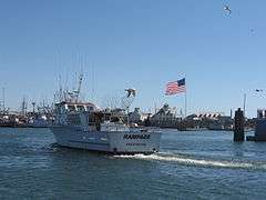 A typical fishing boat returning to the Westport Marina
 The observation tower at Westport


References
- 1 2 "US Gazetteer files 2010". United States Census Bureau. Archived from the original on 2012-01-24. Retrieved 2012-12-19.
- 1 2 "American FactFinder". United States Census Bureau. Retrieved 2012-12-19.
- 1 2 "Population Estimates". United States Census Bureau. Archived from the original on October 19, 2016. Retrieved July 10, 2016.
- ↑ "Westport". Geographic Names Information System. United States Geological Survey.
- ↑ Chandler, Raymond. 1936. Goldfish (short story) in Chandler: Stories and Early Novels. Lewis M. Dabney, ed (New York: Library of America, 1995) ISBN 978-1-883011-07-9
- ↑ "US Gazetteer files: 2010, 2000, and 1990". United States Census Bureau. 2011-02-12. Retrieved 2011-04-23.
- ↑ "Population and Housing Unit Estimates". Retrieved June 9, 2017.
- ↑ "U.S. Decennial Census". Census.gov. Retrieved June 6, 2013.
External links
| Wikimedia Commons has media related to Westport, Washington. |
- Official Website
- Westport Washington - Business Listings, Events Schedule, Images, Classifieds, Weather and more
Municipalities and communities of Grays Harbor County, Washington, United States | ||
|---|---|---|
| Cities | 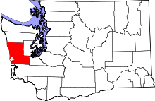 | |
| CDPs | ||
| Other unincorporated communities | ||
| Indian reservations | ||
| Footnotes | ‡This populated place also has portions in an adjacent county or counties | |