Typhoons in the Philippines
| Category | Sustained winds |
|---|---|
| Super Typhoon | ≥119 knots ≥220 km/h |
| Typhoon | 64–119 knots 118–220 km/h |
| Severe Tropical Storm | 48–63 knots 89–117 km/h |
| Tropical Storm | 34–47 knots 62–88 km/h |
| Tropical Depression | ≤33 knots ≤61 km/h |
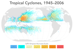

Approximately twenty tropical cyclones enter the Philippine Area of Responsibility yearly, an area which incorporates parts of the Pacific Ocean, South China Sea and the Philippine Archipelago (with the exception of Tawi-Tawi province). Among these cyclones, ten will be typhoons, with five having the potential to be destructive ones.[1] The Philippines is "the most exposed country in the world to tropical storms" according to a Time Magazine article in 2013.[2] In the Philippine languages, typhoons are called bagyo.[3]
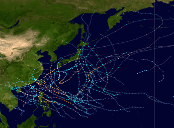
Typhoons can hit the Philippines any time of year, with the months of June to September being most active, with August being the most active individual month and May the least active. Typhoons move east to west across the country, heading north as they go. Storms most frequently make landfall on the islands of Eastern Visayas, Bicol region, and northern Luzon[2] whereas the southern island and region of Mindanao is largely free of typhoons.
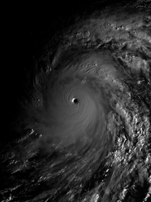
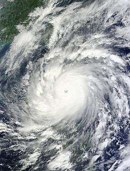
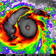
The deadliest overall tropical cyclone to impact the Philippines is believed to have been the Haiphong typhoon which is estimated to have killed up to 20,000 people as it passed over the country in September 1881. In modern meteorological records, the deadliest storm was Typhoon Yolanda (international name Haiyan), which became the strongest landfalling tropical cyclone ever recorded as it crossed the Visayas in central Philippines on November 7–8, 2013. The wettest known tropical cyclone to impact the archipelago was the July 14–18, 1911 cyclone which dropped over 2,210 millimetres (87 in) of rainfall within a 3-day, 15-hour period in Baguio City.[4] Tropical cyclones usually account for at least 30 percent of the annual rainfall in the northern Philippines while being responsible for less than 10 percent of the annual rainfall in the southern islands. PAGASA Senior Weather Specialist Anthony Lucero told the newsite Rappler that the number of destructive typhoons have increased recently but it is too early to call it a trend.[1]
Tropical cyclones entering the Philippine Area of Responsibility are given a local name by the Philippine Atmospheric, Geophysical and Astronomical Services Administration (PAGASA), which also raises public storm signal warnings as deemed necessary.[5][6]
Preparation and response to typhoons is coordinated by the National Disaster Risk Reduction and Management Council (NDRRMC). Each Philippine province and local government in the Philippines has a corresponding Disaster Risk Reduction and Management Office (DRRMO). Each provincial and local government is required to set aside 5% of its yearly budget for disaster risk reduction, preparations, and response.[1]
The frequency of typhoons in the Philippines have made the typhoons a significant part of everyday ancient and modern Filipino culture.[2]
Etymology
Bagyo (sometimes spelled bagyu) is the word for "typhoon" or "storm" in most Philippine languages, including Tagalog, Visayan, Ilocano, Bicolano, Hanunó'o, Aklanon, and Pangasinan. It is derived from Proto-Austronesian *baRiuS, meaning "typhoon". Cognates in other Austronesian languages include Sama baliw ("wind"), Amis faliyos or farios ("typhoon"); Saisiyat balosh ("typhoon"), Babuza bayus ("storm"), Puyuma variw, Bintulu bauy ("wind"), Kelabit bariw ("storm wind"), and Chamorro pakyo ("typhoon").[7]
Storm naming conventions: local and international names
The Joint Typhoon Warning Center in Honolulu started monitoring and naming storms in the Western Pacific region in 1945, originally using female names in English alphabetical order. That list was revised in 1979 by introducing male names to be used in alternation with the female names.[8] The Philippine Weather Bureau started naming storms within their area of responsibility in 1963, using female Filipino names ending in ng in native alphabetical order. The Bureau continued to monitor typhoons until the agency's abolition in 1972, after which its duties were transferred to the newly-established PAGASA. This often resulted in a Western Pacific cyclone carrying two names: an international name and a local name generally used within the Philippines. This two-name scheme is still followed today.
Beginning in 2000, cyclone monitoring duties in the Western Pacific were transferred from the JTWC to the Japan Meteorological Agency, the RSMC of the World Meteorological Organization. The international naming scheme of the typhoons was replaced with a sequential list of names contributed by 14 nations in the region, including the Philippines. The new scheme largely uses terms for local features of the contributing nation, such as animals, plants, foods and adjectives in the native language. The rotation of names is based on the alphabetical order of the contributing nations. The Philippines, however, would maintain its own naming scheme for its local forecasts. In 2001, PAGASA revised its naming scheme to contain longer annual lists with a more mixed set of names.
Currently, the JMA and PAGASA each assign names to typhoons that form within or enter the Philippine Area of Responsibility. The JMA naming scheme for international use contains 140 names described above. The list is not restricted by year; the first name to be used in a typhoon season is the name after the last-named cyclone of the preceding season. The PAGASA naming scheme for Philippine use contains four lists, each containing twenty-five names arranged in alphabetical order. Every typhoon season begins with the first name in the assigned list, and the rolls of names are each reused every four years. An auxiliary list of ten names is used when the main list in a year had been exhausted. Not all Western Pacific cyclones are given names by both weather agencies, as JMA does not name tropical depressions, and PAGASA does not name cyclones outside the Philippine Area of Responsibility.
In the case of both weather agencies, names are retired when a typhoon carrying it caused severe or costly damage and loss of life. Retirement is decided by the agencies' committees, although in PAGASA's case, names are routinely retired when the cyclone caused at least 300 deaths or ₱1 billion in damage in the Philippines. Retired names are replaced with another name for the next rotation, for JMA by the nation that submitted the retired name, and for PAGASA with a name sharing the same first letter as the retired name.
Variability in activity
On an annual time scale, activity reaches a minimum in May, before increasing steadily to June, and spiking from July to September, with August being the most active month for tropical cyclones in the Philippines. Activity reduces significantly in October.[9] The most active season, since 1945, for tropical cyclone strikes on the island archipelago was 1993 when nineteen tropical cyclones moved through the country (though there were 36 storms that were named by PAGASA).[10] There was only one tropical cyclone which moved through the Philippines in 1958.[11] The most frequently impacted areas of the Philippines by tropical cyclones are northern Luzon and eastern Visayas.[12] A ten-year average of satellite determined precipitation showed that at least 30 percent of the annual rainfall in the northern Philippines could be traced to tropical cyclones, while the southern islands receive less than 10 percent of their annual rainfall from tropical cyclones.[13]
Tropical Cyclone Warning Signals
| Signal #1 winds of 30–60 km/h (20-37 mph) are expected to occur within 36 hours |
| Signal #2 winds of 61–120 km/h (38–73 mph) are expected to occur within 24 hours |
| Signal #3 winds of 121–170 km/h, (74–105 mph) are expected to occur within 18 hours. |
| Signal #4 winds of 171–220 km/h, (106–137 mph) are expected to occur within 12 hours. |
| Signal #5 winds of at least 220 km/h, (137 mph) are expected to occur within 12 hours. |
The Philippine Atmospheric, Geophysical and Astronomical Services Administration (PAGASA) releases tropical cyclone warnings in the form of Tropical Cyclone Warning Signals.[6] An area having a storm signal may be under:
- TCWS #1 - Tropical cyclone winds of 30 km/h (19 mph) to 60 km/h (37 mph) are expected within the next 36 hours. (Note: If a tropical cyclone forms very close to the area, then a shorter lead time is seen on the warning bulletin.)
- TCWS #2 - Tropical cyclone winds of 61 km/h (38 mph) to 120 km/h (75 mph) are expected within the next 24 hours.
- TCWS #3 - Tropical cyclone winds of 121 km/h (75 mph) to 170 km/h (110 mph) are expected within the next 18 hours.
- TCWS #4 - Tropical cyclone winds of 171 km/h (106 mph) to 220 km/h (140 mph) are expected within 12 hours.
- TCWS #5 - Tropical cyclone winds greater than 220 km/h (140 mph) are expected within 12 hours.
These Tropical Cyclone Warning Signals are usually raised when an area (in the Philippines only) is about to be hit by a tropical cyclone. As a tropical cyclone gains strength and/or gets nearer to an area having a storm signal, the warning may be upgraded to a higher one in that particular area (e.g. a signal No. 1 warning for an area may be increased to signal #3). Conversely, as a tropical cyclone weakens and/or gets farther to an area, it may be downgraded to a lower signal or may be lifted (that is, an area will have no storm signal).
Classes for Preschool are canceled when Signal No. 1 is in effect. Elementary and High School classes and below are cancelled under Signal No. 2 and classes for Colleges and Universities and below are cancelled under Signal Nos. 3, 4 and 5.
Deadliest Cyclones
| Rank[14] | Storm | Dates of impact | Deaths |
|---|---|---|---|
| 1 | Haiphong 1881 | 1881, September 27 | 20,000 |
| 2 | Haiyan/Yolanda 2013 | 2013, November 7–8 | 6,300[15] |
| 3 | Thelma/Uring 1991 | 1991, November 4–7 | 5,101[16] |
| 4 | Bopha/Pablo 2012 | 2012, December 2–9 | 1,901 |
| 5 | Angela Typhoon | 1867, September 22 | 1,800[17] |
| 6 | Winnie 2004 | 2004, November 27–29 | 1,593 |
| 7 | October 1897 Typhoon | 1897, October 7 | 1,500[17] |
| 8 | Ike/Nitang 1984 | 1984, September 3–6 | 1,492 |
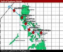
| 9 | Fengshen/Frank 2008 | 2008, June 20–23 | 1,410 |
| 10 | Durian/Reming 2006 | 2006, November 29-December 1 | 1,399 |
Most destructive
|
| ||||
|---|---|---|---|---|
| Rank | Name | Year | PHP | USD |
| 1 | Haiyan (Yolanda) | 2013 | 89.6 billion | 2.02 billion |
| 2 | Bopha (Pablo) | 2012 | 42.2 billion | 1.04 billion |
| 3 | Rammasun (Glenda) | 2014 | 38.6 billion | 871 million |
| 4 | Parma (Pepeng) | 2009 | 27.3 billion | 608 million |
| 5 | Nesat (Pedring) | 2011 | 15 billion | 333 million |
| 6 | Fengshen (Frank) | 2008 | 13.5 billion | 301 million |
| 7 | Megi (Juan) | 2010 | 11 billion | 255 million |
| 8 | Ketsana (Ondoy) | 2009 | 11 billion | 244 million |
| 9 | Mike (Ruping) | 1990 | 10.8 billion | 241 million |
| 10 | Angela (Rosing) | 1995 | 10.8 billion | 241 million |
|
| ||||
|
Sources
| ||||
Wettest recorded tropical cyclones
| Precipitation | Storm | Location | Ref. | ||
|---|---|---|---|---|---|
| Rank | mm | in | |||
| 1 | 2210.0 | 87.01 | July 1911 cyclone | Baguio City | [18] |
| 2 | 1854.3 | 73.00 | Parma (Pepeng) 2009 | Baguio City | [19] |
| 3 | 1216.0 | 47.86 | Carla (Trining) 1967 | Baguio City | [18] |
| 4 | 1116.0 | 43.94 | Zeb (Iliang) 1998 | La Trinidad, Benguet | [20] |
| 5 | 1085.8 | 42.74 | Utor (Feria) 2001 | Baguio City | [21] |
| 6 | 1077.8 | 42.43 | Koppu (Lando) 2015 | Baguio City | [19] |
| 7 | 1012.7 | 39.87 | Mindulle (Igme) 2004 | [22] | |
| 8 | 902.0 | 35.51 | Kujira (Dante) 2009 | [23] | |
| 9 | 879.9 | 34.64 | September 1929 typhoon | Virac, Catanduanes | [24] |
| 10 | 869.6 | 34.24 | Dinah (Openg) 1977 | Western Luzon | [25] |
See also
- 2017 Pacific typhoon season
- 2018 Pacific typhoon season
- List of Pacific typhoon seasons (1939 onwards)
- List of retired Philippine typhoon names
For other storms impacting the Philippines in deadly seasons, see:
References
- 1 2 3 de la Cruz, Gwen (March 19, 2016). "IN NUMBERS: Typhoons in the Philippines and the 2016 polls". Rappler. Retrieved 12 April 2017.
- 1 2 3 Brown, Sophie (November 11, 2013). "The Philippines Is the Most Storm-Exposed Country on Earth". Time. Retrieved 12 April 2017.
- ↑ Glossary of Meteorology. Baguio. Retrieved on 2008-06-11.
- ↑ J. L. H. Paulhaus (1973). World Meteorological Organization Operational Hydrology Report No. 1: Manual For Estimation of Probable Maximum Precipitation. World Meteorological Organization. p. 178.
- ↑ Atlantic Oceanographic and Meteorological Laboratory, Hurricane Research Division. "Frequently Asked Questions: What are the upcoming tropical cyclone names?". NOAA. Retrieved 2006-12-11.
- 1 2 Republic of the Philippines. Department of Science and Technology. Philippine Atmospheric, Geophysical and Astronomical Services Administration. (n.d.). The Modified Philippine Public Storm Warning Signals. Retrieved November 6, 2016.
- ↑ Robert Blust & Stephen Trussel (2010). "*baRiuS". Austronesian Comparative Dictionary. Retrieved 5 September 2018.
- ↑ Padua, David Michael. "Names". Typhoon2000.
- ↑ Ricardo García-Herrera, Pedro Ribera, Emiliano Hernández and Luis Gimeno (2003-09-26). "Typhoons in the Philippine Islands, 1566-1900" (PDF). David V. Padua. p. 40. Retrieved 2010-04-13.
- ↑ Joint Typhoon Warning Center (2009). "Member Report Republic of the Philippines" (PDF). Philippine Atmospheric, Geophysical and Astronomical Services Administration. World Meteorological Organization. Retrieved 2010-04-14.
- ↑ Joint Typhoon Warning Center (1959). "1958". United States Navy. Missing or empty
|url=(help);|access-date=requires|url=(help) - ↑ Colleen A. Sexton (2006). Philippines in Pictures. Twenty-First Century Books. ISBN 978-0-8225-2677-3. Retrieved 2008-11-01.
- ↑ Edward B. Rodgers; Robert F. Adler & Harold F. Pierce. "Satellite-measured rainfall across the Pacific Ocean and tropical cyclone contribution to the total". Retrieved 2008-11-25.
- ↑ Ten Worst Typhoons of the Philippines (A Summary)
- ↑ "TyphoonHaiyan - RW Updates". United Nations Office for the Coordination of Humanitarian Affairs. December 28, 2013. Philippines: Hundreds of corpses unburied after Philippine typhoon. Archived from the original on December 30, 2013. Retrieved December 30, 2013.
- ↑ Leoncio A. Amadore, PhD Socio-Economic Impacts of Extreme Climatic Events in the Philippines. Archived 2008-10-02 at the Wayback Machine. Retrieved on 2007-02-25.
- 1 2 Pedro Ribera; Ricardo Garcia-Herrera & Luis Gimeno (July 2008). "Historical deadly typhoons in the Philippines". Weather. Royal Meteorological Society. 63 (7): 196. Bibcode:2008Wthr...63..194R. doi:10.1002/wea.275.
- 1 2 J. L. H. Paulhaus (1973). World Meteorological Organization Operational Hydrology Report No. 1: Manual For Estimation of Probable Maximum Precipitation. World Meteorological Organization. p. 178.
- 1 2 Nick Wiltgen (October 21, 2015). "Former Super Typhoon Koppu (Lando) Weakens to Remnant Low over Northern Philippines". The Weather Channel. Retrieved October 21, 2015.
- ↑ Guillermo Q. Tabios III; David S. Rojas Jr. Rainfall Duration-Frequency Curve for Ungaged Sites in the High Rainfall, Benguet Mountain Region in the Philippines (PDF) (Report). Kyoto University. Retrieved 2015-06-02.
- ↑ Leoncio A. Amadore, Ph.D. Socio-Economic Impacts of Extreme Climatic Events in the Philippines. Retrieved on 2007-02-25.
- ↑ Padgett, Gary; Kevin Boyle; John Wallace; Huang Chunliang; Simon Clarke (2006-10-26). "Monthly Global Tropical Cyclone Summary June 2004". Australian Severe Weather Index. Jimmy Deguara. Retrieved 2007-01-13.
- ↑ Steve Lang (May 7, 2009). "Hurricane Season 2009: Kujira (Western Pacific Ocean)". NASA. Retrieved December 23, 2011.
- ↑ Coronas, José (September 1929). "Typhoons and Depressions – a Destructive Typhoon Over Southern and Central Luzon on September 2 and 3, 1929" (PDF). Monthly Weather Review. American Meteorological Society. Weather Bureau. 57 (9): 398–399. doi:10.1175/1520-0493(1929)57<398b:TADDTO>2.0.CO;2. Retrieved September 26, 2015.
- ↑ Narciso O. Itoralba (December 1981). Annual Tropical Cyclone Report 1977. Philippine Atmospheric, Geophysical and Astronomical Services Administration. p. 65.
External links
| Wikimedia Commons has media related to Tropical cyclones in the Philippines. |