1993 Pacific typhoon season
| 1993 Pacific typhoon season | |
|---|---|
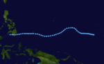
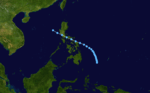
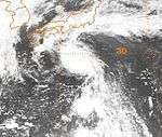
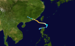
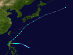
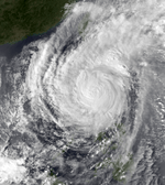
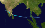
 Season summary map | |
| Seasonal boundaries | |
| First system formed | February 28, 1993 |
| Last system dissipated | January 1, 1994 |
| Strongest storm | |
| Name | Koryn |
| • Maximum winds |
195 km/h (120 mph) (10-minute sustained) |
| • Lowest pressure | 905 hPa (mbar) |
| Seasonal statistics | |
| Total depressions | 49 |
| Total storms | 28 |
| Typhoons | 15 |
| Super typhoons | 3 (unofficial) |
| Total fatalities | >758 |
| Total damage | > $1.96 billion (1993 USD) |
| Related articles | |
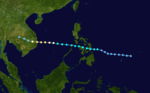
The 1993 Pacific typhoon season has no official bounds; it ran year-round in 1993, but most tropical cyclones tend to form in the northwestern Pacific Ocean between May and November.[1] These dates conventionally delimit the period of each year when most tropical cyclones form in the northwestern Pacific Ocean.
The scope of this article is limited to the Pacific Ocean, north of the equator and west of the international date line. Storms that form east of the date line and north of the equator are called hurricanes; see 1993 Pacific hurricane season. Tropical Storms formed in the entire west pacific basin were assigned a name by the Joint Typhoon Warning Center. Tropical depressions in this basin have the "W" suffix added to their number. Tropical depressions that enter or form in the Philippine area of responsibility are assigned a name by the Philippine Atmospheric, Geophysical and Astronomical Services Administration or PAGASA. This can often result in the same storm having two names.
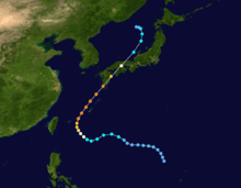
Season summary

Systems
40 tropical cyclones formed this year in the Western Pacific, of which 30 became tropical storms. 15 storms reached typhoon intensity, of which 3 reached super typhoon strength.[2]
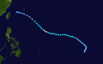
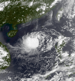
Tropical Depression 01W (Atring)
| Tropical depression (JMA) | |
| Tropical depression (SSHWS) | |
  | |
| Duration | February 28 – March 1 |
|---|---|
| Peak intensity | 55 km/h (35 mph) (10-min) 1010 hPa (mbar) |
Tropical Depression 01W formed on February 27, 1993, near the Philippines. The storm made landfall on Mindanao on March 1, before it dissipated the next day.
Severe Tropical Storm Irma
| Severe tropical storm (JMA) | |
| Tropical storm (SSHWS) | |
  | |
| Duration | March 8 – March 17 |
|---|---|
| Peak intensity | 95 km/h (60 mph) (10-min) 985 hPa (mbar) |
Irma shied away from land masses.
Tropical Depression 03W (Bining)
| Tropical depression (PAGASA) | |
| Tropical depression (SSHWS) | |
  | |
| Duration | April 9 – April 13 |
|---|---|
| Peak intensity | 55 km/h (35 mph) (10-min) 1002 hPa (mbar) |
It formed on April 9 east of Mindanao. It made landfall on Mindanao on April 13 and dissipated later that day.
Tropical Depression 04W (Kuring)
| Tropical depression (PAGASA) | |
| Tropical depression (SSHWS) | |
  | |
| Duration | April 15 – April 27 |
|---|---|
| Peak intensity | 45 km/h (30 mph) (10-min) 1005 hPa (mbar) |
It formed on April 15, 1993. Curving twice, it made landfall on Mindanao. It is the third storm to make landfall in Mindanao this season.
Tropical Depression Daling
| Tropical depression (PAGASA) | |
 | |
| Duration | May 2 – May 4 |
|---|---|
| Peak intensity | 45 km/h (30 mph) (10-min) 1006 hPa (mbar) |
The PAGASA classified the depression as 'Daling' on May 3 as it made landfall over southern Mindanao the next day. It dissipated in the Sulu Sea on May 4.
Tropical Depression Jack
| Tropical depression (JMA) | |
| Tropical storm (SSHWS) | |
  | |
| Duration | May 16 – May 22 |
|---|---|
| Peak intensity | 65 km/h (40 mph) (1-min) 1008 hPa (mbar) |
Jack stayed at sea.
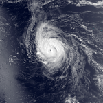
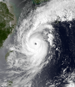
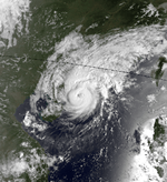
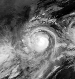
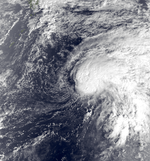
Super Typhoon Koryn (Goring)
| Typhoon (JMA) | |
| Category 4 super typhoon (SSHWS) | |
  | |
| Duration | June 15 – June 29 |
|---|---|
| Peak intensity | 195 km/h (120 mph) (10-min) 905 hPa (mbar) |
Typhoon Koryn, having developed well east of the Philippines on June 13, steadily strengthened as it moved westward, intensifying to a peak of 150 mph (240 km/h) winds on the 24th. It crossed northern Luzon the next day as a slightly weaker 130 mph (210 km/h) typhoon, and continued west-northwestward until hitting southern China (90 nautical miles southwest of Hong Kong on the 27th). Koryn slowly wound down, bringing heavy rain through China and northern Vietnam before dissipating on the 29th. Koryn was responsible for the loss of 37 people, as well as $14.5 million (1993 USD) in damage over the northern Philippines.
Tropical Depression 07W (Elang)
| Tropical depression (PAGASA) | |
| Tropical depression (SSHWS) | |
  | |
| Duration | June 17 – June 20 |
|---|---|
| Peak intensity | 55 km/h (35 mph) (10-min) 1004 hPa (mbar) |
(Elang) made land fall
Severe Tropical Storm Lewis (Huling)
| Severe tropical storm (JMA) | |
| Category 2 typhoon (SSHWS) | |
  | |
| Duration | July 6 – July 13 |
|---|---|
| Peak intensity | 110 km/h (70 mph) (10-min) 975 hPa (mbar) |
Lewis was one of many systems to hit the Philippines that year.
Tropical Storm Marian (Ibiang)
| Tropical depression (JMA) | |
| Tropical storm (SSHWS) | |
  | |
| Duration | July 13 – July 17 |
|---|---|
| Peak intensity | 55 km/h (35 mph) (10-min) 1000 hPa (mbar) |
Marian stayed within the Philippine Sea.
Severe Tropical Storm Nathan
| Severe tropical storm (JMA) | |
| Category 1 typhoon (SSHWS) | |
  | |
| Duration | July 19 – July 25 |
|---|---|
| Peak intensity | 100 km/h (65 mph) (10-min) 980 hPa (mbar) |
Nanthan crossed Japan.
Tropical Storm Ofelia (Luming)
| Tropical storm (JMA) | |
| Tropical storm (SSHWS) | |
 | |
| Duration | July 24 – July 27 |
|---|---|
| Peak intensity | 85 km/h (50 mph) (10-min) 990 hPa (mbar) |
Ofelia moved over Japan.
Severe Tropical Storm Percy (Miling)
| Severe tropical storm (JMA) | |
| Category 1 typhoon (SSHWS) | |
 | |
| Duration | July 26 – July 30 |
|---|---|
| Peak intensity | 110 km/h (70 mph) (10-min) 975 hPa (mbar) |
Percy also struck Japan.
Tropical Depression Narsing
| Tropical depression (PAGASA) | |
|
| |
| Duration | July 29 – July 30 |
|---|---|
| Peak intensity | 55 km/h (35 mph) (10-min) |
On July 29, PAGASA initiated advisories on a poorly organised tropical depression. The depression moved slowly towards the north-west before it dissipated during the next day.[3]
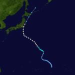
Typhoon Robyn (Openg)
| Typhoon (JMA) | |
| Category 4 typhoon (SSHWS) | |
 | |
| Duration | August 1 – August 11 |
|---|---|
| Peak intensity | 155 km/h (100 mph) (10-min) 940 hPa (mbar) |
The near equatorial trough spawned a tropical depression on July 30 over the open Western Pacific waters. It tracked to the west-northwest, becoming a tropical storm on the 2nd and a typhoon on the 4th. Robyn turned more to the northwest, where it reached a peak intensity of 145 mph (230 km/h) winds on the 7th. It weakened to a 100 mph (200 km/h) typhoon before hitting southwestern Japan on the 9th, and became extratropical on the 10th over the Sea of Japan. Robyn caused 45 fatalities, 39 of which were from traffic related accidents, and $68 million in damage (1993 USD).
Severe Tropical Storm Steve (Pining)
| Severe tropical storm (JMA) | |
| Category 1 typhoon (SSHWS) | |
 | |
| Duration | August 5 – August 14 |
|---|---|
| Peak intensity | 100 km/h (65 mph) (10-min) 980 hPa (mbar) |
Steve stayed clear from land.
Tropical Depression 15W
| Tropical depression (SSHWS) | |
 | |
| Duration | August 13 – August 14 |
|---|---|
| Peak intensity | 45 km/h (30 mph) (1-min) 1002 hPa (mbar) |
Typhoon Tasha (Rubing)
| Typhoon (JMA) | |
| Category 1 typhoon (SSHWS) | |
 | |
| Duration | August 13 – August 22 |
|---|---|
| Peak intensity | 120 km/h (75 mph) (10-min) 970 hPa (mbar) |
Tasha hit China in August.
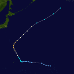
Typhoon Keoni
| Typhoon (JMA) | |
| Category 3 typhoon (SSHWS) | |
  | |
| Duration | August 19 (Entered basin) – September 3 |
|---|---|
| Peak intensity | 165 km/h (105 mph) (10-min) 940 hPa (mbar) |
Keoni formed southeast of the Big Island of Hawaii on August 9, and was later classified as a named system south of the island chain. Keoni peaked as an intense Category 4 hurricane over open waters and lasted until the 29th, crossing the International Date Line and becoming a typhoon in the western Pacific, but never affected land.
Typhoon Vernon
| Typhoon (JMA) | |
| Category 1 typhoon (SSHWS) | |
  | |
| Duration | August 21 – August 28 |
|---|---|
| Peak intensity | 130 km/h (80 mph) (10-min) 965 hPa (mbar) |
The cyclone dropped heavy rainfall across much of the Japanese archipelago.[4] A peak rainfall total occurred of 340 mm (13 in) at Mount Zaō, including a record 319 mm (12.6 in) in 24 hours.[5] A peak hourly rainfall total of 64 mm (2.5 in) was observed in Tokyo.[6] A wind gust of 76 km/h (47 mph) was recorded in Miyake-jima.[7]
Tropical Storm Winona (Saling)
| Tropical storm (JMA) | |
| Tropical storm (SSHWS) | |
  | |
| Duration | August 21 – August 29 |
|---|---|
| Peak intensity | 75 km/h (45 mph) (10-min) 990 hPa (mbar) |
Winona hit China.
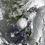
Super Typhoon Yancy (Tasing)
| Typhoon (JMA) | |
| Category 4 super typhoon (SSHWS) | |
  | |
| Duration | August 29 – September 7 |
|---|---|
| Peak intensity | 175 km/h (110 mph) (10-min) 925 hPa (mbar) |
The monsoon trough formed a tropical depression on August 27. It headed generally westward, reaching tropical storm strength on the 30th and typhoon strength on the 31st. Yancy turned to the northeast, where it rapidly intensified to a 150 mph (240 km/h) super typhoon on the 2nd. The storm weakened to a 135 mph (217 km/h) typhoon before making landfall on southwestern Japan on the 3rd, and dissipated 2 days later over the Sea of Japan. Yancy brought strong winds to Japan, amounting to 42 casualties and widespread damage.
Severe Tropical Storm Zola (Unsing)
| Severe tropical storm (JMA) | |
| Tropical storm (SSHWS) | |
 | |
| Duration | September 5 – September 9 |
|---|---|
| Peak intensity | 95 km/h (60 mph) (10-min) 985 hPa (mbar) |
Zola was another weak system that hit Japan.
Typhoon Abe (Walding)
Abe was another typhoon that hit China.
| Typhoon (JMA) | |
| Category 3 typhoon (SSHWS) | |
  | |
| Duration | September 9 – September 15 |
|---|---|
| Peak intensity | 155 km/h (100 mph) (10-min) 945 hPa (mbar) |
Typhoon Becky (Yeyeng)
| Severe tropical storm (JMA) | |
| Category 1 typhoon (SSHWS) | |
  | |
| Duration | September 13 – September 18 |
|---|---|
| Peak intensity | 100 km/h (65 mph) (10-min) 980 hPa (mbar) |
Becky struck China to the west of Macau at full force. The offshore waters in the southern and southwestern part of Hong Kong recorded hurricane-force winds where its hourly mean winds reached 122 km/h with gusts up to 176 km/h at Waglan Island. In Cheung Chau, winds increased significantly to 115 km/h hourly before under going maintenance; privately recorded its hourly winds of up to 128 km/h during its first hour of maintenance there in Cheung Chau. In Tai Mo Shan, its hourly mean winds reached 155 km/h.
Becky was clearly underestimated and the hurricane signal 10 should have been hoisted if it was justified (hurricane-force winds recorded at 2 stations when Becky traversed at about 110 km south-southwest of the Royal Observatory). Its maximum 10 minute sustained wind speed was estimated to be at around 130 km/h at its closet approach to Hong Kong.
The typhoon killed 1 taxi driver at a car accident in Hong Kong. As of 2017, Becky was revised and upgraded to a minimal typhoon.
Typhoon Dot (Anding)
| Typhoon (JMA) | |
| Category 1 typhoon (SSHWS) | |
  | |
| Duration | September 19 – September 27 |
|---|---|
| Peak intensity | 130 km/h (80 mph) (10-min) 965 hPa (mbar) |
Dot struck China as well. Initially posing a direct hit to Hong Kong but it slowly moved north, striking the coast of western Guangdong.
Typhoon Cecil
| Typhoon (JMA) | |
| Category 3 typhoon (SSHWS) | |
  | |
| Duration | September 22 – September 27 |
|---|---|
| Peak intensity | 150 km/h (90 mph) (10-min) 950 hPa (mbar) |
Cecil recurved out to sea.
Super Typhoon Ed (Binang)
| Typhoon (JMA) | |
| Category 5 super typhoon (SSHWS) | |
  | |
| Duration | September 30 – October 8 |
|---|---|
| Peak intensity | 185 km/h (115 mph) (10-min) 915 hPa (mbar) |
Ed was a potent typhoon but did not affect land.
Typhoon Flo (Kadiang)
| Typhoon (JMA) | |
| Category 1 typhoon (SSHWS) | |
  | |
| Duration | October 1 – October 8 |
|---|---|
| Peak intensity | 120 km/h (75 mph) (10-min) 970 hPa (mbar) |
Typhoon Flo hit the northern Philippines on October 4 as a minimal typhoon, having developed on the 28th from the monsoon trough. It stalled just off the west coast, and turned northeastward, becoming extratropical on the 9th. Flo caused at least 50 deaths from the heavy flooding on Luzon.
Tropical Storm Gene (Dinang)
| Tropical storm (JMA) | |
| Tropical storm (SSHWS) | |
  | |
| Duration | October 7 – October 10 |
|---|---|
| Peak intensity | 65 km/h (40 mph) (10-min) 998 hPa (mbar) |
Gene was a weak system that stayed away from land.
Tropical Depression 28W (Epang)
| Tropical depression (PAGASA) | |
| Tropical depression (SSHWS) | |
  | |
| Duration | October 7 – October 13 |
|---|---|
| Peak intensity | 45 km/h (30 mph) (10-min) 1008 hPa (mbar) |
The depression criss crossed land.
Tropical Depression Gundang
| Tropical depression (PAGASA) | |
|
| |
| Duration | – |
|---|---|
| Peak intensity | Winds not specified |
Severe Tropical Storm Hattie
| Severe tropical storm (JMA) | |
| Tropical storm (SSHWS) | |
  | |
| Duration | October 19 – October 25 |
|---|---|
| Peak intensity | 95 km/h (60 mph) (10-min) 980 hPa (mbar) |
Hattie recurved from land.
Typhoon Ira (Husing)
| Typhoon (JMA) | |
| Category 4 typhoon (SSHWS) | |
  | |
| Duration | October 27 – November 5 |
|---|---|
| Peak intensity | 150 km/h (90 mph) (10-min) 950 hPa (mbar) |
Ira struck the Philippines.
Tropical Storm Jeana
| Tropical storm (JMA) | |
| Tropical storm (SSHWS) | |
  | |
| Duration | November 5 – November 13 |
|---|---|
| Peak intensity | 85 km/h (50 mph) (10-min) 992 hPa (mbar) |
Jeana stayed at sea.
Tropical Depression 32W (Indang)
| Tropical depression (PAGASA) | |
| Tropical depression (SSHWS) | |
  | |
| Duration | November 13 – November 19 |
|---|---|
| Peak intensity | 55 km/h (35 mph) (10-min) 1002 hPa (mbar) |
32W was long-lived.
Tropical Depression 33W
| Tropical depression (SSHWS) | |
  | |
| Duration | November 18 – November 19 |
|---|---|
| Peak intensity | 45 km/h (30 mph) (1-min) 1002 hPa (mbar) |
33W was short-lived.
Typhoon Kyle (Luring)
| Typhoon (JMA) | |
| Category 2 typhoon (SSHWS) | |
  | |
| Duration | November 17 – November 24 |
|---|---|
| Peak intensity | 130 km/h (80 mph) (10-min) 960 hPa (mbar) |
Kyle was yet another Philippines striking system. It also hit Vietnam.
Tropical Depression BOB 03
| Tropical depression (SSHWS) | |
 | |
| Duration | November 27 – November 30 |
|---|---|
| Peak intensity | 55 km/h (35 mph) (1-min) 1003 hPa (mbar) |
Typhoon Lola (Monang)
| Typhoon (JMA) | |
| Category 3 typhoon (SSHWS) | |
  | |
| Duration | December 1 – December 9 |
|---|---|
| Peak intensity | 150 km/h (90 mph) (10-min) 955 hPa (mbar) |
The near equatorial trough spawned a tropical depression on November 27. It moved westward without significant development until December 2, when it became a tropical storm. Lola became a typhoon 2 days later, and hit the Philippines on the 5th. It weakened to a tropical storm after crossing the islands, but restrengthened to a 125 mph (200 km/h) typhoon before hitting southern Vietnam on the 8th. Lola quickly dissipated, not after causing 308 fatalities, 230 of which were in the Philippines from the heavy rains.
Typhoon Manny (Naning)
| Typhoon (JMA) | |
| Category 4 typhoon (SSHWS) | |
  | |
| Duration | December 3 – December 16 |
|---|---|
| Peak intensity | 140 km/h (85 mph) (10-min) 955 hPa (mbar) |
Manny, like Lola, developed from the near equatorial trough on December 1. It headed westward, slowly strengthening to a tropical storm on the 4th. Due to a ridge to the north, it looped on the 7th and 8th and became a typhoon on the way. While heading southwestward towards the Philippines, Manny rapidly intensified to a 135 mph (220 km/h) typhoon before hitting the Philippines late on the 9th. It weakened over the islands, and upper level winds kept it from restrengthening much over the South China Sea. Manny dissipated on the 16th over the Malay Peninsula, after causing 230 deaths, only one week after Lola hit the same area.
Manny's track was unusual, given its time of year with a loop and a strengthening period to the southwest. However, it has a near perfect analog; Typhoon Pamela in the 1982 Pacific typhoon season took a nearly identical track within days of Manny (though Pamela was much weaker than Manny).
Tropical Depression Oning
| Tropical depression (PAGASA) | |
|
| |
| Duration | December 14 – December 16 |
|---|---|
| Peak intensity | 55 km/h (35 mph) (10-min) |
A non-tropical system developed from the ITCZ of where Manny formed on December 11. It moved in a fairly fast westward direction as it gradually intensified into a weak tropical depression late on December 14. The PAGASA issued warnings on the depression as it reached peak intensity late on December 15, making landfall over the islands of Visayas.
Severe Tropical Storm Nell (Puring)
| Severe tropical storm (JMA) | |
| Category 1 typhoon (SSHWS) | |
  | |
| Duration | December 20, 1993 – January 1, 1994 |
|---|---|
| Peak intensity | 110 km/h (70 mph) (10-min) 975 hPa (mbar) |
Nell was the final system to hit the Philippines this year.
Storm names
During the season 28 named tropical cyclones developed in the Western Pacific and were named by the Joint Typhoon Warning Center, when it was determined that they had become tropical storms. These names were contributed to a revised list which started on mid-1989.
| Irma | Jack | Koryn | Lewis | Marian | Nathan | Ofelia | Percy | Robyn | Steve | Tasha | Vernon | Winona | Yancy | Zola |
| Abe | Becky | Cecil | Dot | Ed | Flo | Gene | Hattie | Ira | Jeana | Kyle | Lola | Manny | Nell |
Philippines
| Atring | Bining | Kuring | Daling | Elang |
| Goring | Huling | Ibiang | Luming | Miling |
| Narsing | Openg | Pining | Rubing | Saling |
| Tasing | Unsing | Walding | Yeyeng | |
| Auxiliary list | ||||
|---|---|---|---|---|
| Anding | Binang | Kadiang | Dinang | Epang |
| Gundang | Husing | Indang | Luring | Monang |
| Naning | Oning | Puring | ||
The Philippine Atmospheric, Geophysical and Astronomical Services Administration uses its own naming scheme for tropical cyclones in their area of responsibility. PAGASA assigns names to tropical depressions that form within their area of responsibility and any tropical cyclone that might move into their area of responsibility. Should the list of names for a given year prove to be insufficient, names are taken from an auxiliary list, the first 6 of which are published each year before the season starts. Names not retired from this list will be used again in the 1997 season. This is the same list used for the 1989 season. PAGASA uses its own naming scheme that starts in the Filipino alphabet, with names of Filipino female names ending with "ng" (A, B, K, D, etc.). Names that were not assigned/going to use are marked in gray.
Season effects
This table summarizes all the systems that developed within or moved into the North Pacific Ocean, to the west of the International Date Line during 1993. The tables also provide an overview of a systems intensity, duration, land areas affected and any deaths or damages associated with the system.
| Name | Dates active | Peak classification | Sustained wind speeds |
Pressure | Areas affected | Damage (USD) |
Deaths | Refs |
|---|---|---|---|---|---|---|---|---|
| 01W (Atring) | February 28 – March 1 | Tropical depression | 55 km/h (35 mph) | 1010 hPa (29.83 inHg) | Philippines | None | None | |
| Irma | March 8 – 19 | Severe tropical storm | 95 km/h (60 mph) | 985 hPa (29.09 inHg) | Marshall Islands, Caroline Islands | None | 10 | |
| 03W (Bining) | April 9 – 13 | Tropical depression | 55 km/h (35 mph) | 1002 hPa (29.59 inHg) | Caroline Islands, Philippines | None | None | |
| 04W (Kuring) | April 19 – 26 | Tropical depression | 55 km/h (35 mph) | 1008 hPa (29.77 inHg) | Caroline Islands, Philippines | None | None | |
| Daling | May 2 – 4 | Tropical depression | 45 km/h (30 mph) | 1006 hPa (29.71 inHg) | Philippines | None | None | |
| Jack | May 16 – 22 | Tropical depression | 65 km/h (40 mph) | 1008 hPa (29.77 inHg) | Caroline Islands, Mariana Islands | None | None | |
| Koryn (Goring) | June 16 – 29 | Typhoon | 195 km/h (120 mph) | 905 hPa (27.02 inHg) | Caroline Islands, Philippines, China | $224 million | 37 | |
| 07W (Elang) | June 17 – 20 | Tropical depression | 55 km/h (35 mph) | 1008 hPa (29.77 inHg) | Philippines | None | None | |
| Lewis (Huling) | July 7 – 13 | Severe tropical storm | 95 km/h (60 mph) | 985 hPa (29.09 inHg) | Philippines, South China, Vietnam | Unknown | Unknown | |
| TD | July 13 | Tropical depression | Not specified | 1002 hPa (29.59 inHg) | Caroline Islands, Mariana Islands | None | None | |
| Marian (Ibiang) | July 14 – 16 | Tropical storm | 75 km/h (45 mph) | 1000 hPa (29.53 inHg) | None | None | None | |
| TD | July 17 – 22 | Tropical depression | Not specified | 1008 hPa (29.77 inHg) | None | None | None | |
| Nathan | July 19 – 25 | Severe tropical storm | 100 km/h (65 mph) | 980 hPa (28.94 inHg) | Mariana Islands, Japan | Unknown | Unknown | |
| TD | July 21 | Tropical depression | Not specified | 1008 hPa (29.77 inHg) | None | None | None | |
| Ofelia (Luming) | July 24 – 27 | Tropical storm | 85 km/h (50 mph) | 990 hPa (29.23 inHg) | Japan | Unknown | Unknown | |
| Percy (Miling) | July 27 – 30 | Severe tropical storm | 100 km/h (65 mph) | 980 hPa (28.94 inHg) | Mariana Islands, Japan | Unknown | Unknown | |
| Narsing | July 30 – 31 | Tropical depression | 55 km/h (35 mph) | 1000 hPa (29.53 inHg) | None | None | None | |
| TD | July 31 | Tropical depression | Not specified | 1002 hPa (29.59 inHg) | Philippines, Taiwan | None | None | |
| Robyn (Openg) | August 1 – 11 | Typhoon | 155 km/h (100 mph) | 940 hPa (27.76 inHg) | Caroline Islands, Mariana Islands, Japan, South Korea | $68 million | 45 | |
| Steve (Pining) | August 6 – 14 | Severe tropical storm | 100 km/h (65 mph) | 980 hPa (28.94 inHg) | Mariana Islands, Ryukyu Islands | None | None | |
| 15W | August 13 – 14 | Tropical depression | 45 km/h (30 mph) | 1002 hPa (29.59 inHg) | Marshall Islands | None | None | |
| Tasha (Rubing) | August 15 – 22 | Typhoon | 120 km/h (75 mph) | 970 hPa (28.79 inHg) | Philippines, China | None | None | |
| Keoni | August 19 – September 3 | Typhoon | 165 km/h (105 mph) | 940 hPa (27.76 inHg) | None | None | None | |
| Vernon | August 21 – 28 | Typhoon | 130 km/h (85 mph) | 960 hPa (28.35 inHg) | Japan | None | None | |
| Winona (Saling) | August 22 – 29 | Tropical storm | 75 km/h (45 mph) | 990 hPa (29.23 inHg) | Philippines, Vietnam | Unknown | Unknown | |
| TD | August 23 – 25 | Tropical depression | Not specified | 1002 hPa (29.59 inHg) | Mariana Islands | None | None | |
| Yancy (Tasing) | August 29 – September 4 | Typhoon | 175 km/h (100 mph) | 925 hPa (27.32 inHg) | Japan | $1.67 billion | 48 | |
| Zola (Unsing) | September 5 – 9 | Severe tropical storm | 95 km/h (60 mph) | 985 hPa (29.09 inHg) | Japan | None | None | |
| TD | September 7 – 8 | Tropical depression | Not specified | 1006 hPa (29.71 inHg) | Philippines | None | None | |
| Abe (Walding) | September 9 – 15 | Typhoon | 155 km/h (100 mph) | 940 hPa (27.76 inHg) | Philippines, Taiwan, China | Unknown | None | |
| Becky (Yeyeng) | September 13 – 18 | Typhoon | 120 km/h (75 mph) | 980 hPa (28.94 inHg) | Philippines, South China | None | 1 | |
| Dot (Anding) | September 20 – 27 | Typhoon | 130 km/h (85 mph) | 965 hPa (28.65 inHg) | Philippines, China | Unknown | None | |
| Cecil | September 23 – 27 | Typhoon | 155 km/h (100 mph) | 940 hPa (27.76 inHg) | Mariana Islands | None | None | |
| Ed (Binang) | September 30 – October 8 | Typhoon | 185 km/h (115 mph) | 915 hPa (27.32 inHg) | Caroline Islands, Mariana Islands | None | None | |
| Flo (Kadiang) | October 1 – 8 | Typhoon | 185 km/h (115 mph) | 915 hPa (27.32 inHg) | Philippines, Ryukyu Islands | Unknown | 10 | |
| 28W (Epang) | October 6 – 13 | Tropical depression | 45 km/h (30 mph) | 1002 hPa (29.59 inHg) | Philippines, South China | None | None | |
| Gene (Dinang) | October 7 – 10 | Tropical storm | 65 km/h (40 mph) | 998 hPa (29.47 inHg) | Caroline Islands | None | None | |
| Hattie | October 19 – 25 | Severe tropical storm | 95 km/h (60 mph) | 980 hPa (28.94 inHg) | Marshall Islands | None | None | |
| TD | October 22 | Tropical depression | Not specified | 992 hPa (29.29 inHg) | None | None | None | |
| Ira (Husing) | October 27 – November 5 | Typhoon | 150 km/h (90 mph) | 950 hPa (28.05 inHg) | Caroline Islands, Mariana Islands, Philippines, China | Unknown | Unknown | |
| Jeana | November 5 – 10 | Tropical storm | 85 km/h (50 mph) | 992 hPa (29.29 inHg) | Caroline Islands | None | None | |
| Indang | November 12 – 13 | Tropical depression | 45 km/h (30 mph) | 1008 hPa (29.77 inHg) | Philippines | None | None | |
| 32W | November 13 – 16 | Tropical depression | 45 km/h (30 mph) | 1002 hPa (29.59 inHg) | Caroline Islands | None | None | |
| 33W | November 17 – 19 | Tropical depression | 45 km/h (30 mph) | 1002 hPa (29.59 inHg) | Marshall Islands | None | None | |
| Kyle (Luring) | November 17 – 24 | Typhoon | 130 km/h (80 mph) | 960 hPa (28.35 inHg) | Philippines, Vietnam, Cambodia | Unknown | Template:Mts | |
| Lola (Monang) | December 1 – 9 | Typhoon | 150 km/h (90 mph) | 955 hPa (28.20 inHg) | Caroline Islands, Philippines, Vietnam, Cambodia | Unknown | 308 | |
| Manny (Naning) | December 3 – 16 | Typhoon | 140 km/h (85 mph) | 955 hPa (28.20 inHg) | Philippines, Vietnam, Thailand | Unknown | 230 | |
| Oning | December 14 – 16 | Tropical depression | 55 km/h (35 mph) | 1004 hPa (29.65 inHg) | Philippines | None | None | |
| Nell (Puring) | December 21, 1993 – January 1, 1994 | Severe tropical storm | 110 km/h (70 mph) | 975 hPa (28.79 inHg) | Philippines | None | None | |
| Season aggregates | ||||||||
| 49 systems | February 28, 1993 – January 1, 1994 | 195 km/h (120 mph) | 905 hPa (27.02 inHg) | >$1.96 billion | >758 | |||
See also
- List of Pacific typhoon seasons
- 1993 Pacific hurricane season
- 1993 Atlantic hurricane season
- 1993 North Indian Ocean cyclone season
- South-West Indian Ocean cyclone season: 1992–93, 1993–94
- Australian region cyclone season: 1992–93, 1993–94
- South Pacific cyclone season: 1992–93, 1993–94
References
- ↑ Gary Padgett. May 2003 Tropical Cyclone Summary. Archived September 25, 2006, at the Wayback Machine. Retrieved 2006-08-26.
- ↑ 1993 ATCR TABLE OF CONTENTS
- ↑ https://groups.google.com/group/sci.geo.meteorology/browse_thread/thread/ca1d22d7d8d2b32/d5c752421a8838cc?
- ↑ Asanobu, Kitamoto. Typhoon 199311 (Robyn). Digital Typhoon (Report). National Institute of Informatics. Retrieved October 1, 2017.
- ↑ Asanobu, Kitamoto. AMeDAS ZAOSAN (35476) @ Typhoon 199311. Digital Typhoon (Report). National Institute of Informatics. Retrieved October 1, 2017.
- ↑ Asanobu, Kitamoto. AMeDAS TOKYO (44131) @ Typhoon 199311. Digital Typhoon (Report). National Institute of Informatics. Retrieved October 1, 2017.
- ↑ Asanobu, Kitamoto. AMeDAS MIYAKEJIMA (44226) @ Typhoon 199311. Digital Typhoon (Report). National Institute of Informatics. Retrieved October 1, 2017.
External links
- Japan Meteorological Agency
- Joint Typhoon Warning Center.
- China Meteorological Agency
- National Weather Service Guam
- Hong Kong Observatory
- Macau Meteorological Geophysical Services
- Korea Meteorological Agency
- Philippine Atmospheric, Geophysical and Astronomical Services Administration
- Taiwan Central Weather Bureau
- Satellite movie of 1993 Pacific typhoon season