River Tyne
| River Tyne | |
| river | |
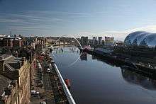
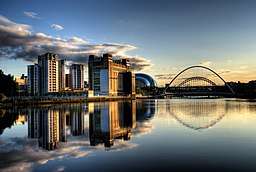 River Tyne Quayside | |
| Country | United Kingdom |
|---|---|
| Constituent country | England |
| Tributaries | |
| - left | River Derwent |
| Primary source | South Tyne |
| - location | Alston Moor, Cumbria, England |
| Secondary source | North Tyne |
| - location | Deadwater Fell, Kielder, Northumberland, England |
| Mouth | Tynemouth |
| - location | South Shields, Tyne and Wear, England |
| - coordinates | 55°0′37″N 1°25′8″W / 55.01028°N 1.41889°WCoordinates: 55°0′37″N 1°25′8″W / 55.01028°N 1.41889°W |
| Length | 118 km (73 mi) [1] |
| Basin | 2,933 km2 (1,132 sq mi) [2] |
| Discharge | for Bywell |
| - average | 44.6 m3/s (1,575 cu ft/s) [2] |
| Wikimedia Commons: River Tyne, England | |
The River Tyne /ˈtaɪn/ (![]()
The Tyne Rivers Trust measure the whole Tyne catchment as 2,936 square kilometres (1,134 sq mi), containing around 4,399 kilometres (2,733 mi) of waterways.[3]
Course
North Tyne
The North Tyne rises on the Scottish border, north of Kielder Water. It flows through Kielder Forest, and in and out of the border. It then passes through the village of Bellingham before reaching Hexham.
South Tyne
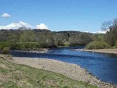
The South Tyne rises on Alston Moor, Cumbria and flows through the towns of Haltwhistle and Haydon Bridge, in a valley often called the Tyne Gap. Hadrian's Wall lies to the north of the Tyne Gap. Coincidentally the source of the South Tyne is very close to the sources of the other two great rivers of the industrial north east namely the Tees and the Wear. The South Tyne Valley falls within the North Pennines Area of Outstanding Natural Beauty (AONB) - the second largest of the 40 AONBs in England and Wales.
Combined Tyne
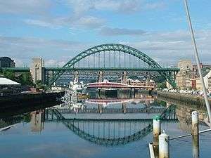
The combined Tyne flows from the convergence point at Warden Rock just to the north west of Hexham, the area where the river's now thriving barbel stocks were first introduced in the mid-1980s, through Corbridge in Northumberland. It enters the county of Tyne and Wear between Clara Vale (in the Borough of Gateshead on the south bank) and Tyne Riverside Country Park (in Newcastle upon Tyne on the north bank) and continues to divide Newcastle and Gateshead for 13 miles (21 km), in the course of which it is spanned by 10 bridges. To the east of Gateshead and Newcastle, the Tyne divides Hebburn and Jarrow on the south bank from Walker and Wallsend on the north bank. Jarrow and Wallsend are linked underneath the river by the Tyne Tunnel. Finally it flows between South Shields and Tynemouth into the North Sea.[2]
Geology and Geography
The late Thomas John Taylor supposed that the main course of the river anciently flowed through what is now Team Valley, its outlet into the tidal river being by a waterfall at Bill Point (in the area of Bill Quay). His theory is not far from the truth, as there is evidence that prior to the last Ice Age, the River Wear did once follow the current route of the lower River Team, merging with the Tyne at Dunston. Ice diverted the course of the Wear to its current location, flowing east the course of the Tyne) and joining the North Sea at Sunderland.
The River Tyne is believed to be around 30 million years old.[4]
Conservation history
The conservation of the Tyne has been handled by various bodies over the past 500 years. Conservation bodies have included: Newcastle Trinity House,[5] and the Tyne Improvement Commission.[5] The Tyne Improvement Commission conservation lasted from 1850 until 1968.[5] The 1850-1950 era was the worst period for pollution of the river.[5] The Tyne Improvement Commission laid the foundations for what has become the modern day Port of Tyne.[6] Under the management of the Tyne Improvement Commissioners, over a period of the first 70 years the Tyne was deepened from 1.83 to 9.14 meters and had 150 million tonnes dredged from it.[6] Inside these 70 years, the two Tyne piers were built;[6] Northumbrian, Tyne and Albert Docks were built[6] as well as the staithes at Whitehill and Dunston.[6] This infrastructure enabled millions of tonnes of cargo to be handled by the Port by 1910.[6] As of 2018 the tidal river is now managed by the Port of Tyne Authority, and has been managed by the Port of Tyne Authority since 1968.[5][6]
Port of Tyne
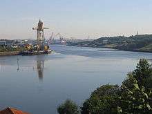
With its proximity to surrounding coalfields, the Tyne was a major route for the export of coal from the 13th century until the decline of the coal mining industry in North East England in the second half of the 20th century. The largest coal staithes were located at Dunston in Gateshead, Hebburn and Tyne Dock, South Shields. The dramatic wooden staithes (a structure for loading coal onto ships) at Dunston, built in 1890, have been preserved, although they were partially destroyed by fire in 2006.[7] In 2016, Tyne Dock, South Shields was still involved with coal, importing 2 million tonnes of shipments a year. The lower reaches of the Tyne were, in the late 19th and early 20th centuries, one of the world's most important centres of shipbuilding, and there are still shipyards in South Shields and Hebburn to the south of the river. To support the shipbuilding and export industries of Tyneside, the lower reaches of the river were extensively remodelled during the second half of the 19th century, with islands removed and meanders in the river straightened.
Origins of name
Nothing definite is known of the origin of the designation Tyne, nor is the river known by that name until the Saxon period: Tynemouth is recorded in Anglo-Saxon as Tinanmuðe (probably dative case). There is a theory that *tīn was a word that meant "river" in the local Celtic language or in a language spoken in England before the Celts came: compare Tardebigge. There is also a river Tyne that rises in Midlothian in Scotland and flows through East Lothian into the North Sea. The River Vedra on the Roman map of Britain may be the Tyne, or may be the River Wear.
A supposed pre-Celtic root *tei, meaning 'to melt, to flow' has also been proposed as an etymological explanation of the Tyne and similarly-named rivers,[8] as has a Brittonic derivative of Indo-European *teihx, meaning 'to be dirty' (Welsh tail, 'manure').[8]
River crossings
River Tyne
- Shields Ferry (ferry service between North and South Shields)
- New Tyne Tunnel (road)
- Old Tyne Tunnel (road)
- Tyne Pedestrian & Cycle Tunnel (foot, bicycle)
- Gateshead Millennium Bridge (foot, bicycle)
- Tyne Bridge (road, foot)
- Swing Bridge (road, foot)
- High Level Bridge (rail, road, foot)
- Queen Elizabeth II Metro Bridge (Metro light rail)
- King Edward VII Bridge (rail)
- Redheugh Bridge (road, foot)
- Scotswood Bridge (road, foot)
- Scotswood Railway Bridge (disused rail, now carries water and gas mains)
- Blaydon Bridge (road)
- Newburn Bridge (road, foot)
- Wylam Bridge (road, foot)
- Wylam Railway Bridge (foot, bicycle, disused rail)
- Ovingham Footbridge (foot)
- Ovingham Bridge (road)
- Bywell Bridge (road, foot)
- Styford Bridge (road, foot)
- Corbridge Bridge (road, foot)
- Hexham Bridge (road, foot)
- Hexham Old Bridge (road, swept away 1771)
- Border Counties Bridge (former rail, only piers remain)
- Constantius Bridge (road)
26 crossings in total
River North Tyne
- Chesters Bridge (ruined Roman bridge)
- Chollerford Bridge (road, foot)
- Wark Bridge (foot)
- Bellingham Bridge (road, foot)
- Tarset Bridge (road, foot)
- Greystead Bridge (foot)
- Falstone Bridge (road, foot)
- Kielder Viaduct (foot – previously rail)
- Kerseycleugh Bridge (road, foot)
7 crossings in total, 6 in use
River South Tyne
- Warden Railway Bridge (rail)
- Warden Bridge (road, foot)
- New Haydon Bridge (road)
- Old Haydon Bridge (foot)
- Haydon Bridge Viaduct (road, foot)
- Lipwood Railway Bridge (rail)
- Ridley Bridge (road, foot)
- Ridley Railway Bridge (rail)
- Millhouse Bridge (at Bardon Mill) (foot)
- Haltwhistle A69 Bridge, East (road)
- Alston Arches Viaduct (at Haltwhistle) (disused rail)
- Blue Bridge, Haltwhistle (at Haltwhistle) (foot – previously road)
- Bellister Bridge (at Haltwhistle) (foot – previously road)
- Haltwhistle A69 Bridge, West (road, foot)
- Featherstone Bridge (road, foot)
- Featherstone Castle Footbridge (foot)
- Diamond Oak Bridge (at Coanwood) (road, foot)
- Lambley Footbridge (foot)
- Lambley Viaduct (foot – previously rail)
- Eals Footbridge (foot)
- Eals Bridge (road, foot)
- Parson Shields Farm Bridge (road, private)
- Slaggyford Bridge (road)
- Kirkhaugh Footbridge (foot)
- Harbut Lodge Railway Bridge (rail)
- Tyne (or Brewery) Bridge (at Alston) (road, foot)
- Garrigill Bridge (road, foot)
27 crossings in total
Artworks and sculpture
Newcastle-upon-Tyne

The river is represented, and personified, in a sculpture unveiled in 1968 as part of the new Civic Centre (seat of Newcastle City Council). Sculpted by David Wynne, the massive bronze figure incorporates flowing water into its design.[9]
Salmon Trail
The Environment Agency is currently working with architects and cultural consultancy xsite, in collaboration with Commissions North, to create a travelling sculpture trail along the River Tyne.
The Tyne Salmon Trail[10] will serve as a celebration of the river, its heritage and its increasingly diverse ecosystem. Historically a major symbol in the regional identity of the North East of England, the river plays host to a plethora of different species, the number of which is growing year on year in line with the rivers improving health.
The Tyne Salmon Trail looks to capture the imagination of residents and tourists visiting the area - providing them with the ultimate 'fact finding' design experience, which celebrates the salmon's migratory journey in the Northeast of England.
FINS, REFLECTION and JOURNEY were the first 3 cubes to be launched in December 2007 from a family of 10. Each cube is inspired by the textures, changing colours, movement and journey of the salmon. With each offering a 'modern day keepsake' to take away, in the form of a designed Bluetooth message.
The other cubes will be moving along the River Tyne over 1 year visiting different locations from Kielder to the Mouth of the Tyne in the summer 2008 before starting their long journey back to their birthplace.
Conversation Piece
Bamboo Bridge
For three days, between 18–20 July 2008, a temporary bamboo artwork was installed over the Tyne close to the Gateshead Millennium Bridge. The Bambuco Bridge was created as part of that year's 'SummerTyne' festival.
Conservation
The River Tyne has a charity dedicated to protecting and enhancing its waters and surrounding areas. The Tyne Rivers Trust, established in 2004, is a community-based organisation that works to improve habitat, promote better understanding of the Tyne catchment area and build the reputation of the Tyne catchment as a place of environmental excellence.[12]
Songs featuring the Tyne
- Asonance - Kopce u pramenů řeky Tyne / Hills on Tyne's source (a Czech adaptation of the folk song The Rolling Hills of the Borders, which does not mention the Tyne)
- Blur - This Is a Low
- Busker - Home Newcastle
- Elvis Costello - Oliver's Army
- Elton John - Merry Christmas Maggie Thatcher (Billy Elliot musical)
- Mark Knopfler - Sailing to Philadelphia, Why Aye Man, Fare Thee Well Northumberland, 5.15 A.M.
- Lindisfarne - Fog on the Tyne
- Madness - Driving in My Car
- Jimmy Nail - Big River
- Gretchen Peters - England Blues
- Hilton Valentine - River Tyne
- Kate Rusby - Bring Me a Boat
- Sting - All This Time, I Was Brought To My Sense
- Dire Straits - Southbound Again, Down to the Waterline
- Gazza - Fog on the Tyne
- Traditional, covered by Sting - Waters of Tyne
- Renaissance - Back Home Once Again (The Paper Lads' TV Theme)
- Roger Whittaker - Durham Town (even though Durham is actually on the River Wear and not the Tyne)
- Eric Burdon and the Animals - The Immigrant Lad
- The Nice - Five Bridges Suite
- Genesis - Blood on the Rooftops
- Big Big Train - Swan Hunter
See also
- Association of Rivers Trusts
- Rivers of the United Kingdom
- Tyne Valley, Prince Edward Island
- Tuxedo Princess
- Northeast England
- Tyne, the name of one of the sea areas of the British Shipping Forecast.
References
- 1 2 Owen, Susan; et al. (2005). Rivers and the British Landscape. Carnegie. ISBN 978-1-85936-120-7.
- 1 2 3 "Environment Agency - River Tyne Salmon Action Plan Review" (PDF). Environment Agency - APEM REF EA 410230. July 2008. Archived from the original (PDF) on 28 March 2014. Retrieved 17 May 2013.
- ↑ "Facts & Figures". tyneriverstrust.org. 2 June 2013. Archived from the original on 22 June 2013. Retrieved 2 June 2013.
The Tyne Catchment covers 2,936 km2 (1,134 sq mi) and contains around 4,399 km (2,733 mi) of waterways. In the language of the Water Framework Directive (which currently drives so much of what is done on rivers) the Tyne Catchment contains 116 river water bodies and 19 lake water bodies.
- ↑ Tyne river trust staff. "The Tyne's origins". Archived from the original on 26 March 2017. Retrieved 30 July 2017.
- 1 2 3 4 5 Henderson, Tony (16 January 2015), "River Tyne's story revealed in study by environmental historian", The Journal, North East England
- 1 2 3 4 5 6 7 Port of Tyne staff (30 July 2017). "Tyne Improvement Commission". portoftyne.co.uk. Port of Tyne. Retrieved 30 July 2017.
- ↑ "Coal heritage goes up in flames". bbc.co.uk. 20 November 2003. Retrieved 25 August 2008.
"The staithes is a lot more than just a lump of wood in the Tyne, it is a magnificent structure and very important to the area's industrial heritage.
- 1 2 "The Brittonic Language in the Old North" (PDF). Scottish Place Name Society.
- ↑ Usherwood, Beach & Morris (2000). Public Sculpture of North-East England. Liverpool University Press.
- 1 2 "Tyne Salmon Trail". 2008. Archived from the original on 7 August 2008. Retrieved 22 August 2008.
Ten cubes inspired by the textures, changing colours, movement and journey of the salmon will migrate along the River Tyne, following the amazing journey of the salmon.
- ↑ Strug, Leah (21 July 2008). "Attraction's sending art lovers fishy messages". South Shields Gazette.
- ↑ "Tyne Rivers Trust". Charity. Tynerivertrust.org. 2008. Retrieved 25 August 2008.
The Tyne Rivers Trust is an independent charity established to assist in management and improvement of the environment in the Tyne Catchment. The Trust aims to achieve this through Actions to: Improve Habitat; Get Better Information and Promote Better Understanding; Grow the Reputation of the Tyne Catchment and the Tyne Rivers Trust nationally and internationally
External links
| Wikimedia Commons has media related to River Tyne. |