Tučapy (Tábor District)
| Tučapy | |||
|---|---|---|---|
| Municipality | |||
| |||
 Tučapy | |||
| Coordinates: 49°17′28″N 14°48′12″E / 49.29111°N 14.80333°ECoordinates: 49°17′28″N 14°48′12″E / 49.29111°N 14.80333°E | |||
| Country |
| ||
| Region | South Bohemian | ||
| District | Tábor | ||
| Area | |||
| • Total | 18.56 km2 (7.17 sq mi) | ||
| Elevation | 455 m (1,493 ft) | ||
| Population (2011) | |||
| • Total | 765 | ||
| • Density | 41/km2 (110/sq mi) | ||
| Postal code | 391 26 to 392 01 | ||
| Website | http://www.tucapy.cz | ||
_-_obecn%C3%AD_%C3%BA%C5%99ad.jpg)
Municipal office in Tučapy
Tučapy is a village and municipality (obec) in Tábor District in the South Bohemian Region of the Czech Republic.
The municipality covers an area of 18.56 square kilometres (7.17 sq mi), and has a population of 791 (as at 28 August 2006).
Tučapy lies approximately 18 kilometres (11 mi) south-east of Tábor, 43 km (27 mi) north-east of České Budějovice, and 93 km (58 mi) south of Prague.
Sights
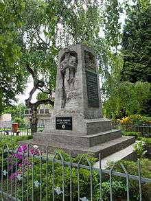
Memorial to the victims of the World War
- Saint James Church
- Jewish cemetery in the south-east part of the village
- small chapel in the north-east part of the village
- Saint John Nepomuk statue
- Jewish school
- Memorial plaques to remember Friedrich von Berghtold and world-known conductor Karel Ančerl (1908–1973), who was born here
- Memorial to those killed in the World Wars
People
It was the birthplace of:
- Karel Ančerl, Czech conductor
References
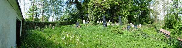
Jewish cemetery in Tučapy
| Wikimedia Commons has media related to Tučapy (Tábor District). |
| Wikimedia Commons has media related to Jewish cemetery in Tučapy). |
This article is issued from
Wikipedia.
The text is licensed under Creative Commons - Attribution - Sharealike.
Additional terms may apply for the media files.