Chrbonín
| Chrbonín | |||
|---|---|---|---|
| Municipality | |||
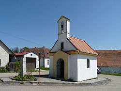 Chapel of the Assumption | |||
| |||
 Chrbonín | |||
| Coordinates: 49°21′35″N 14°52′19″E / 49.35972°N 14.87194°ECoordinates: 49°21′35″N 14°52′19″E / 49.35972°N 14.87194°E | |||
| Country |
| ||
| Region | South Bohemian | ||
| District | Tábor | ||
| Area | |||
| • Total | 7.08 km2 (2.73 sq mi) | ||
| Elevation | 588 m (1,929 ft) | ||
| Population (2006) | |||
| • Total | 140 | ||
| • Density | 20/km2 (51/sq mi) | ||
| Postal code | 391 55 | ||

Chrbonín is a village and municipality (obec) in Tábor District in the South Bohemian Region of the Czech Republic.
The municipality covers an area of 7.08 square kilometres (2.73 sq mi), and has a population of 140 (as at 3 July 2006).
Chrbonín lies approximately 17 kilometres (11 mi) east of Tábor, 52 km (32 mi) north-east of České Budějovice, and 87 km (54 mi) south of Prague.
References
| Wikimedia Commons has media related to Chrbonín. |
This article is issued from
Wikipedia.
The text is licensed under Creative Commons - Attribution - Sharealike.
Additional terms may apply for the media files.