Jistebnice
| Jistebnice | ||
|---|---|---|
| Municipality | ||
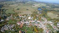 Aerial view | ||
| ||
 Jistebnice | ||
| Coordinates: 49°29′20″N 14°32′10″E / 49.48889°N 14.53611°ECoordinates: 49°29′20″N 14°32′10″E / 49.48889°N 14.53611°E | ||
| Country |
| |
| Region | South Bohemian | |
| District | Tábor | |
| Area | ||
| • Total | 57.94 km2 (22.37 sq mi) | |
| Elevation | 578 m (1,896 ft) | |
| Population (2015) | ||
| • Total | 2,009 | |
| • Density | 35/km2 (90/sq mi) | |
| Postal code | 391 31 to 391 33 | |
| Website | http://www.jistebnice.cz | |
.svg.png)
Jistebnice (German: Gistebnitz, older Gistebning[1]) is a town and municipality (obec) in Tábor District in the South Bohemian Region of the Czech Republic.
The municipality covers an area of 57.94 square kilometres (22.37 sq mi), and has a population of 2,012 (as at 2 October 2006).
Jistebnice lies approximately 13 kilometres (8 mi) north-west of Tábor, 58 km (36 mi) north of České Budějovice, and 67 km (42 mi) south of Prague.
Jistebnice became a town for the first time before 1654.[2] It lost this statute after 1945 and it became a town again on 17 October 2011.[3]
References
- Specific
- ↑ http://gauss.suub.uni-bremen.de/suub/hist/index.jsp?id=V.2.a.235-137a
- ↑ Kuča, Karel (1997). Města a městečka v Čechách, na Moravě a ve Slezsku, 2. díl [Cities and market towns in Bohemia, Moravia and Silesia, vol. 2] (in Czech). Prague: Libri, s.r.o. ISBN 80-85983-14-1.
- ↑ Rozhodnutí č. 23 předsedkyně Poslanecké sněmovny
| Wikimedia Commons has media related to Jistebnice. |
This article is issued from
Wikipedia.
The text is licensed under Creative Commons - Attribution - Sharealike.
Additional terms may apply for the media files.