Smilovy Hory
| Smilovy Hory | |||
|---|---|---|---|
| Municipality | |||
 Smilovy Hory | |||
| |||
 Smilovy Hory | |||
| Coordinates: 49°32′11″N 14°52′42″E / 49.53639°N 14.87833°ECoordinates: 49°32′11″N 14°52′42″E / 49.53639°N 14.87833°E | |||
| Country |
| ||
| Region | South Bohemian | ||
| District | Tábor | ||
| Area | |||
| • Total | 20.81 km2 (8.03 sq mi) | ||
| Elevation | 643 m (2,110 ft) | ||
| Population (2006) | |||
| • Total | 410 | ||
| • Density | 20/km2 (51/sq mi) | ||
| Postal code | 391 52 | ||
| Website | http://mesta.obce.cz/smilovy-hory | ||

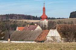
Smilovy Hory is a village and municipality (obec) in Tábor District in the South Bohemian Region of the Czech Republic.
The municipality covers an area of 20.81 square kilometres (8.03 sq mi), and has a population of 410 (as at 28 August 2006).
Smilovy Hory lies approximately 21 kilometres (13 mi) north-east of Tábor, 69 km (43 mi) north-east of České Budějovice, and 70 km (43 mi) south-east of Prague.
References
| Wikimedia Commons has media related to Smilovy Hory. |
This article is issued from
Wikipedia.
The text is licensed under Creative Commons - Attribution - Sharealike.
Additional terms may apply for the media files.